Overview
This website provides access to early-release data sets on ice thickness, snow depth, and ice characteristics collected in March/April of 2012 in the North American Arctic. Data were obtained by different projects, centering around the National Aeronautics and Space Administration's (NASA) Operation IceBridge survey flights with key contributions by activities supported through the National Science Foundation (NSF) for the interagency Arctic Observing Network (AON).
The goal of this early release of preliminary data is to provide timely information to the international sea-ice prediction community for initialization of seasonal ice predictions, in particular for the North American Arctic sector. This work, including the contributions by NASA's Operation IceBridge and AON projects, in particular the Seasonal Ice Zone Observing Network (SIZONet), is motivated by the Arctic Sea Ice Outlook, an international forum for the synthesis and dissemination of seasonal ice projections, led by the U.S. Study of Environmental Arctic Change (SEARCH).
The data release includes contributions from different U.S. federal agency, private industry, and international partners to provide timely sea-ice data of broader relevance in the North American Arctic. The data acquisition reflect collaboration with local government and co-management boards to avoid interfering with subsistence hunting activities and provide information of relevance to coastal communities.

Datasets
1. NASA Operation IceBridge Quicklook Data
The NASA Operation IceBridge Sea Ice Freeboard, Snow Depth, and Thickness Quicklook data set is an evaluation product containing derived geophysical data products retrieved over the arctic sea ice cover from 14 March to 02 April 2012 using the IceBridge Airborne Topographic Mapper (ATM), Snow Radar, Digital Mapping System (DMS), and KT19 pyrometer. This quicklook product is experimental and is designed to be applicable for time-sensitive projects such as sea ice forecasting.
2012 Operation Ice Bridge Arctic Sea Ice Thickness Data:
http://nsidc.org/data/docs/daac/icebridge/evaluation_products/sea-ice-f…
Operation IceBridge Data Portal (Full Dataset and Documentation):
http://nsidc.org/icebridge/portal/
2. SIZONet Airborne Electromagnetic-induction (EM) Ice Thickness Surveys Quicklook Data
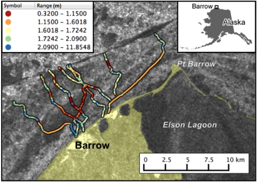
A team of researchers from the University of Alaska Fairbanks and Alfred Wegner Institute recently carried out a helicopter-based electromagnetic (HEM) survey based out of Barrow, Alaska, to measure sea ice thickness in the western Beaufort Sea. This was the first sea ice mission using the Multi-frequency Airborne Sea Ice Explorer (MAiSIE), which is expected to provide improved thickness measurements in deformed ice and shallow water and provides additional validation of the IceBridge ice thickness data derived from laser altimeter. The HEM survey included three sorties over the pack ice north and east of Barrow on April 7 and 9, 2012 and a fourth sortie over grounded ridges in the landfast ice on April 12. Preliminary quicklook data are available through the Advanced Cooperative Arctic Data Information Service:
2012 Airborne EM Ice Thickness Data Download:
Flight 1 (north & east):
http://www.aoncadis.org/download/fileDownload.htm?fileAccessPointId=4ea…
Flight 2 (east) :
http://www.aoncadis.org/download/fileDownload.htm?fileAccessPointId=3a0…
Flight 3 (north):
http://www.aoncadis.org/download/fileDownload.htm?fileAccessPointId=43c…
Full Data set and Documentation:
http://www.aoncadis.org/dataset/barrow_airborne_sea_ice_thickness_surve…
3. Fugro Airborne P-band Synthetic Aperture Radar (SAR) Survey Quicklook Data
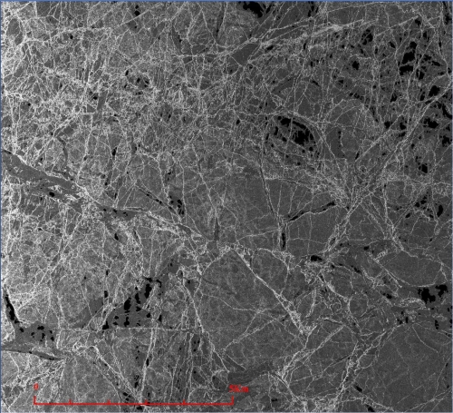
On 9 April 2012 a Gulfstream 2 aircraft joined the campaign, operated by Fugro Earth Data, Inc. Flying at 38,000 ft, this aircraft scanned the sea ice with GeoSAR, a dual-band, single-pass interferometric synthetic aperture radar (IFSAR) mapping system. Data are still undergoing final processing and quality control; a quicklook version of the P-band imagery will be linked from this site later this year. More information about the GeoSAR system can be found at: http://www.geosar.com/.

4. NRL Tandem Flight Airborne LiDAR and Radar Altimeter Surveys
Also during April, a twin otter operated by a team from the Naval Research Laboratory (NRL) was conducting aerial surveys using a scanning LiDAR to measure the 3-D surface topography of the snow and a coherent radar altimeter, which mapped the snow/ice interface. On two sorties, on April 7 and 9, 2012 the twin otter flew in tandem with helicopter to achieve synchronous acquisition of LiDAR, radar altimeter, and HEM data. Data are still undergoing final processing and quality control; a sample of the digital elevation data collected along the tandem flights will be available for download later this year.
Sample Tandem LiDAR Data Link (Available on or around 1 July 2012)
5. SIZONet Surface-based EM Survey Data (Barrow Landfast Ice Region & Drifting Multiyear Ice Site)
Surface-based ice thickness surveys were conducted using a Geonics EM-31 along hunter trails on the landfast ice near Barrow as well as on drifting ice offshore during helicopter landings. Data are available through ACADIS:
2012 Surface EM Ice Thickness Data Download Links:
Data(.xls):
http://www.aoncadis.org/download/fileDownload.htm?fileAccessPointId=f81…
Full Dataset and Documentation:
http://www.aoncadis.org/dataset/ground-based_sea_ice_thickness_profiles…

6. BREA Airborne Electromagnetic-induction (EM) Ice Thickness Survey
As part of the Canadian Beaufort Regional Environmental Assessment (BREA) project as well as the Canadian Arctic Sea Ice Mass Balance Observatory (CASIMBO) and German Polar Airborne Measurements and Arctic Regional Climate Model Simulation Project (PAMARCMIP), researchers from the University of Alberta and Alfred Wegener Institute performed an airborne ice thickness survey over the Southern Beaufort Sea between Inuvik and Sachs Harbour, Northwest Territories, Canada. Measurements were carried out with a towed EM probe operated by a Basler BT67 aircraft. The 270 km long survey captured predominantly first-year ice, but also includes few scattered very thick multiyear ice floes. Thickness data from a prominent ice island at the northeastern end of the profile were excluded from the file provided here to avoid bias towards too large thicknesses.
More information:
Haas, C., Lobach, J., Hendricks, S., Rabenstein, L., Pfaffling, A. (2009). Helicopter-borne measurements of sea ice thickness, using a small and lightweight, digital EM system, Journal of Applied Geophysics, 67(3), 234-241.
Full data set and Documentation:
http://www.polardata.ca/whitesnow/Download?fileLoc=/pdc/brea/11470/CCIN…
http://www.polardata.ca/whitesnow/Download?fileLoc=/pdc/brea/11470/CCIN…
7. CRREL-AON Ice Mass-balance Buoy Data
Scientists from the US Cold Regions Research and Engineering Laboratory (CRREL) have deployed ice mass balance buoys (IMBs) in the Beaufort Sea as part of SIZONet and AON. These buoys record changes in the thickness of ice and snow and the temperature of the air, snow, ice and water, providing information on the onset and extent of bottom and surface melt and hence potential lifetime of ice in the region prior to disintegration. Near-real time (updated at 0h00 and 12h00 UTC daily) and archival data are available through CRREL:
8. SIZONet Snow and Ice Property Measurements
Ice cores have been taken from the landfast ice near Barrow as well from a multiyear floe offshore north of Point Barrow. Data include salinity profiles, snow properties, and ice stratigraphy from photographs. Data are available through ACADIS:
2012 Sea Ice Core Property Data Download Links:
http://www.aoncadis.org/download/fileDownload.htm?fileAccessPointId=9d5…
Full Dataset and Documentation:
http://www.aoncadis.org/dataset/sea-ice_core_measurements.html
Contacts
NASA Operation IceBridge:
Jackie Richter-Menge (Jacqueline.A.Richter-Menge [at] usace.army.mil)
Cold Regions Research and Engineering Laboratory (CRREL), Hanover, NH, USA
Michael Studinger (michael.studinger [at] nasa.gov)
Goddard Space Flight Center, Greenbelt, MD, USA
SIZONet:
Andy Mahoney (Mahoney [at] gi.alaska.edu)
Hajo Eicken (hajo.eicken [at] gi.alaska.edu)
University of Alaska Fairbanks, Fairbanks, Alaska, USA
Stefan Hendricks (Stefan.Hendricks [at] awi.de)
Alfred Wegener Institute for Polar and Marine Research, Bremerhaven, Germany
Matthew Druckenmiller (druckenmiller [at] nsidc.org)
National Snow and Ice Data Center, Boulder, Colorado, USA
Don Perovich (Donald.K.Perovich [at] usace.army.mil)
Chris Polashenski (Christopher.M.Polashenski [at] Dartmouth.edu)
Cold Regions Research and Engineering Laboratory (CRREL), Hanover, NH, USA
GeoSAR:
Joe Jones (jjones [at] fugro.com)
GeoSAR Program Manager, Fugro EarthData Inc. 7320 Executive Way, Frederick, MD, USA
Naval Research Laboratory:
Joan M. Gardner, Ph.D. (joan.gardner [at] nrl.navy.mil)
Naval Research Laboratory, 4555 Overlook Ave. S.W., Washington, DC, USA
Acknowledgements
We wish to thank CH2MHill Polar Services and UMIAQ for logistical support in Barrow and Era Helicopters for support of the HEM flights out of Barrow. SIZONet is supported through NSF grant 0856867. CRREL AON Ice Mass Balance Buoys are support by NSF grant 0856376 and NOAA's Arctic Research Office. Any opinions, findings, and conclusions or recommendations expressed on this website are those of the authors and do not necessarily reflect the views of NSF or other sponsors or collaborators.
Further Information
NASA Operation IceBridge (http://www.nasa.gov/mission_pages/icebridge/)
SIZONet (www.sizonet.org)
SEARCH Arctic Sea Ice Outlook (http://www.arcus.org/search/seaiceoutlook/index.php)
GeoSAR (http://www.geosar.com/)
Fugro Earth Data, Inc. (http://www.fugroearthdata.com/)


