In the Department of Earth Sciences (http://earthsciences.dartmouth.edu/), research and teaching emphasize watershed processes, environmental geochemistry, glaciology, geomicrobiology, structural geology and geophysics, sedimentology, paleontology, and remote sensing. A number of faculty specialize in low temperature geochemistry, stable and radiogenic isotopes, hydrology, glacial dynamics, geomorphology, soils, and climate.
With funding from the NSF Arctic Natural Sciences Program, Meredith Kelly examines past extents of ice sheets and mountain glaciers to better understand both recent and ancient (10,000 to 100,000 years ago) climate events. Shrinking glaciers in Greenland's Scoresby Sund region have revealed partially fossilized vegetation that grew at times when glaciers were smaller than at present. By examining this vegetation, as well as sediment cores and moraines, Kelly and Integrative Graduate Education and Research Traineeship (IGERT) student Laura Levy are learning about glacial response to temperatures as high as, or higher than, at present.

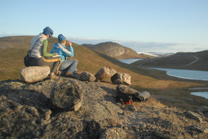
Integrative Graduate Education and Research Traineeship (IGERT) students Laura Levy (right) and Simone Whitecloud (left) sampling a boulder for surface exposure dating on a glacial moraine near Kangerlussuaq, West Greenland, during summer 2009. Levy is working with Meredith Kelly in the Department of Earth Sciences examining recent and ancient climate events based on past glacial extents. The surface exposure dating method enables determination of the time that the boulder has been exposed to the atmosphere based on the concentration of cosmogenic-produced nuclides on its surface, such as Beryllium-10 and Aluminum-26. In this photo, Levy and Whitecloud are measuring the angle to the topographic horizon to calculate the amount of cosmogenic radiation the sample is exposed to. Horizon measurements are used to determine the amount of shielding by local landforms that incoming cosmic rays experience. Photo by Meredith Kelly.
Bob Hawley's research primarily focuses on the firn layer of polar ice sheets. "Firn" is old snow that has become granular and compacted. Hawley's investigations into techniques for measuring in-situ density profiles of polar firn in 2002 led to the development of a technique called Borehole Optical Stratigraphy, in which a video camera is lowered down a borehole in the ice, and a recording is made of the patterns of light and dark in the borehole walls. These patterns of light and dark are associated with variations in ice grain size and density and can be related to the annual layers commonly used to date ice cores in high-accumulation locations.
Hawley is currently working with researchers from the University of Texas, National Aeronautics and Space Administration (NASA), and Swiss Federal Institute of Technology on an NSF-funded project investigating the nature and cause of short-term velocity changes of the Greenland Ice Sheet. The research team is using an integrated observational approach, which includes borehole geophysics, Global Positioning Systems (GPS), and modeling, to examine interactions between the ice sheet, atmosphere, and base of the ice.
From March through June 2010, Hawley will complete a coast-to-summit trek across the Greenland Ice Sheet as part of a collaborative project with the U.S. Army Cold Regions Research and Engineering Laboratory (CRREL). He and his team, which includes IGERT graduate student Gifford Wong, will dig snow pits and drill shallow boreholes to measure physical properties of the snowpack. The data will help interpret measurements of the ice sheet made from space. His traverse will pass near several routes taken by Carl Benson of CRREL during the 1950s and will allow him to observe long-term changes in the nature of the snowpack at many elevations.
Xiahong Feng investigates climate and environmental change using stable isotopes and meteorological and ecological observations. With funding from the U.S. Department of Energy and the Jet Propulsion Laboratory, one of her current projects will provide a quantitative understanding of the link between sea ice and moisture sources of arctic precipitation. Specifically, Feng and her team are studying the composition of oxygen and hydrogen isotopes in precipitation collected during storm events at stations in Barrow and Atqasuk, Alaska. By looking at isotopic ratios in precipitation in association with weather patterns and ocean surface conditions, the researchers can determine how much moisture in a given storm is contributed by the arctic sea surface and how much of this contribution is controlled by sea ice extent. Stations in Canada, Norway, Greenland, and Russia are under development for similar sampling programs.
In collaboration with Ross Virginia, professor of environmental studies, and researchers at the National Oceanic and Atmospheric Administration (NOAA), Norwegian Institute for Air Research, CRREL, and others, Feng also investigates ecological and hydrological responses of the Arctic to climate change using stable isotopic measurements of soil organic matter, plant tissue, and surface water.
