Permafrost thaw, a result of ongoing high latitude warming, has a number of consequences ranging from infrastructure damage to accelerated release of carbon and methane to the atmosphere. Despite the important role of permafrost in the geological, ecological, engineering, and climate change sciences, direct interaction between the dispersed permafrost community and the climate modeling community is limited.
In a project funded by the NSF Arctic Natural Sciences program, Vladimir Romanovsky and John Walsh, both of the University of Alaska Fairbanks (UAF), are working to integrate climate change modeling and permafrost science in ways that are responsive to user needs. Working with colleagues from the Danish Meteorological Institute, Technical University of Denmark, Arctic Technology Center of Greenland, and Asiaq of Greenland, Romanovsky and Walsh are using large-scale climate models to better understand recent and future permafrost variability, retreat, and degradation in Greenland and Alaska.


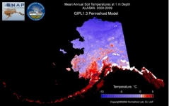
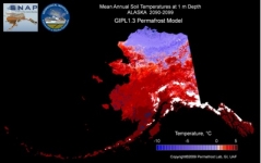
Developed over the past three years, the Geophysical Institute Permafrost Lab (GIPL) model was designed specifically to assess the effect of a changing climate on permafrost. The images above show ground temperatures at 1 meter depth in Alaska for the periods 2000–2009 (top) and 2090–2099 (bottom). Large areas of land that are presently below freezing (top image blue areas) will warm to above-freezing annual mean temperatures (bottom image red areas) by the 2090s. These simulations were developed using downscaled global climate model output to drive the GIPL 1.3 model and calibrated using field measurements from various Alaskan sites.
Permafrost is widespread in both western Greenland and northern Alaska but has different characteristics in each area. In Greenland, bedrock is present near the surface and can be used as a building foundation. In Alaska, bedrock is not typically near the surface and, therefore, communities and infrastructure are more susceptible to permafrost degradation. Because the two permafrost areas are so different geographically, there is potential for extrapolation of the findings to other permafrost areas in the Arctic. For example, Alaska is similar to interior areas of Siberia, while western Greenland is more analogous to some permafrost-affected areas of northern Europe.
For this comparative study of permafrost, which includes measurements, modeling, and impact assessment, the research team has established a series of 11 monitoring sites—four in Alaska and seven in Greenland—representative of the range of permafrost types encountered in the two countries. Using data collected from these locations, as well as from other previously established observing sites in Alaska, the researchers are mapping present-day permafrost conditions and modeling the projected evolution of permafrost in the two regions through 2099.
Projected scenarios are generated using the Geophysical Institute Permafrost Lab (GIPL) 1.3 model, which was developed over the past three years and designed specifically to assess the effect of a changing climate on permafrost. Initial project results indicate that major changes in permafrost temperature and distribution will take place both in Greenland and Alaska during the 21st century. The area of permafrost degradation in Alaska, however, is projected to be more substantial—by the end of the 21st century, permafrost will still be stable only in the Brooks Range and on the North Slope (see images this page). By contrast, the models suggest that more than half of the present-day permafrost area in Greenland will remain stable, although active layer depths will increase.
This project targets the needs of residents, stakeholders, and planners in the respective regions. Walsh and Romanovsky will share research results with civil engineers and land managers, including information about the present sensitivity of permafrost to climate stress and how permafrost within these regions might change under different scenarios of climate variability. They are currently in the process of using their findings to develop "risk maps" for specific regions, which will accompany recommendations concerning infrastructure and engineering. Other plans include projections for specific locations identified by community members in Alaskan villages. The site-specific concerns of village residents are already being identified through visits to western Alaska communities by project team members.
For more information, contact John Walsh (jwalsh [at] iarc.uaf.edu) or Vladimir Romanovsky (veromanovsky [at] alaska.edu) at UAF.
