
Assessment of Current Ice Conditions Relevant to Distribution and Access of Walrus
Click the name of each community below to view more frequently updated and detailed information from the National Weather Service.
Synopsis High pressure remains over the Chukchi Sea while low pressure sits in the Gulf of Alaska.
Near St. Lawrence Island
No shorefast ice is left around St. Lawrence Island. There is an area of compacted ice against the coast between Gambell and Savoonga up to 1.3 miles (0.5 km) offshore with mostly open water beyond. An area of close pack ice sits 20 miles (32 km) northwest of Gambell as well as 45 miles (72 km) southwest of Gambell. Waters around Savoonga are open, with two small areas of close pack ice 15 miles (24 km) to the north and 25 miles (40 km) to the northeast. There remains a large area of compacted ice between Ataakas Camp and Camp Kulowiye that extends up to 22 miles (35 km) offshore. Beyond is open water. and area of close pack ice is streaming off the compact ice 5 miles (8 km) off the east side of the island. Sea ice free conditions exist on the south side of the island. Most remaining ice in the area appears to be brash ice to ice cakes with very few small to medium floes left.
Nome
Sea ice free waters extend for at least 50 miles in all directions from Nome.
Nome port entrance webcam (via AOOS webpage): https://bering-sea.portal.aoos.org/?ls=79875242-e362-65cb-914e-fed20ff9…
Brevig Mission/Port Clarence Area
Several areas of open pack ice remain between Pt. Spencer and Tin City consisting of brash ice to ice cakes with a few small floes. Ice-free conditions exist beyond 23 miles (37 km) south of the coast.
Wales to Shishmaref
Compact pack ice extends 13 miles (21 km) to the north of Wales and 2 miles (3 km) to the north of Shishmaref. Beyond the compact ice is open water.
Diomede
Waters around Diomede are sea ice free. The closest ice is several areas of open pack ice near Wales and 20 miles (32 km) west of Diomede.
Forecast Discussion
Ice Forecast
Persistent northerly winds over the next week will move drifting pack ice southward 30 to 50 nm. Currents will bring some remaining pack ice from the Gulf of Anadyr up the Russian coast northwest of Gambell. Some of this ice will drift back southward toward St. Lawrence Island. The compact ice along northeastern St. Lawrence Island will continue to stream off the east side of the island and melt as it moves southward. Compact ice along the Wales to Shishmaref coast will remain compacted by the northerly winds and continue to stream into the waters south of Wales.


Wind Synopsis
North winds 15 to 25 mph (13 to 22 knots) on Friday, June 10th will persist at St. Lawrence Island into Saturday, June 11th before dissipating to 10 to 15 mph (8 to 13 knots) by Monday, June 13th. Stronger north winds 25 to 35 mph (22 to 30 knots) with gusts to 45 mph (39 knots) through the Bering Strait Friday, June 10th will gradually decrease throughout the weekend to 15 to 25 mph (13 to 22 knots) by Monday, June 13th. These winds through the Bering Strait and around St. Lawrence Island will persist into Wednesday, June 15th before south to southeast winds 5 to 15 mph (4 to 13 knots) develop by Thursday, June 16th, with east to southeast winds 5 to 15 mph (4 to 13 knots) developing by Friday, June 17th.
Temperature Trend
Temperatures will be in the mid to upper 30s, with St. Lawrence Island slightly warmer than the Bering Strait on Friday, June 10th. Temperatures will hover in the mid to upper 30s through the weekend, before warming conditions into the upper 30s to low 40s by Monday, June 13th. Temperatures will warm slightly throughout the week, but still generally staying in the upper 30s to low 40s, with St. Lawrence Island in the lower 40s and the Bering Strait in the upper 30s.
Daily Weather, Wind, and Temperature Updates
The National Weather Service provides twice-daily, text-only updates on the weather, wind, and temperature conditions in specific geographical zones. An interactive weather map for access to other Alaskan zones can be found here: http://weather.gov/anchorage/ice
Higher resolution satellite images and wind maps (wind updated daily) can be viewed here: http://www.weather.gov/afg/SIWO_overview
The Alaska Ocean Observing System shares a variety of weather and sea ice related resources in their Bering Sea Portal at https://bering-sea.portal.aoos.org/.
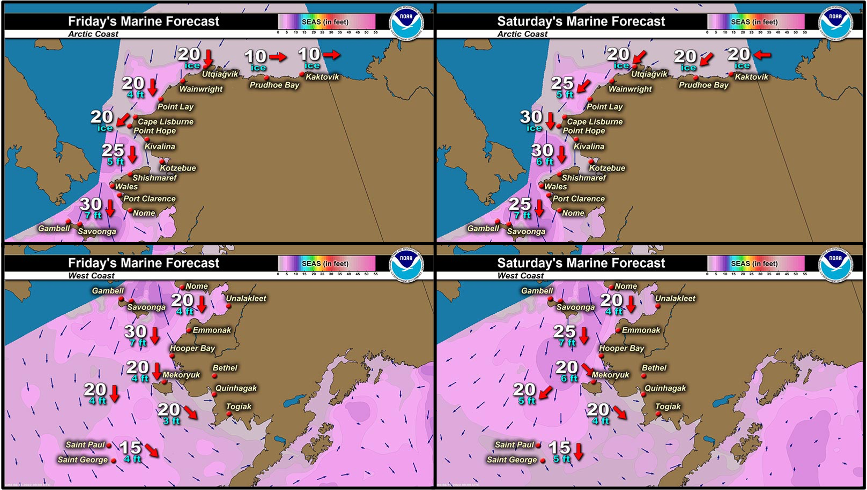
Marine forecast for the West Coast and Arctic Coast
Remote Sensing Images


Observations and Comments
Observations of Sea Ice Development
Observations from Wales
Thursday, 9 June 2022 – Robert Tokeinna, Jr.
I wanted to let you know the Shorefast Ice in Wales has broken off the point and we are seeing waves on the beach. I imagine that the ice will break up from the wave action and continue to break off elsewhere. These past weeks have been interesting. Warm winds, foggy days, sunny and windy, and some what calm warm weather. However, the fog has left us, it was with us throughout the weekend. Our last plane was on Saturday morning and finally see one this morning. Temperatures have been typical in the lower 30s, with foggy days in the lower 20s, and winds were residual 10 to 15 mph with the occasional gusts to 40 mph winds this past weekend. Lots of birds and ducks passing by, more recently locals have been finding duck and sea gull eggs. Our Village Creek piled up with water from the thawing of the snow then it naturally drained out couple days later. We have been getting icicles for drinking water and local heavy equipment broke trail in and around town for wheeled transportation. Pictures to come. Have a great week.
Observations from Port Clarence, Brevig Mission, and Cape Douglas
Friday, 10 June 2022 – Marcus Barr
Shorefast ice blew off after strong northerly winds for about a week, very little ice left Southside of the Port Clarence Bay.

Observations from Gambell
Friday, 10 June 2022 – Clarence Irrigoo, Jr.
Lots of open water and all that ice is gone. Fog and rough water last week stay home.
Observations from Savoonga
Friday, 10 - June 2022 – Aqef Waghiyi
Nobody went boating this week. North winds all week. Don’t see no more ice. When the weather gets good some boats were planning on going. After I see no ice past couple days I pulled out my fishing gear, trout, salmon whatever fish we could get.
Observations from Shishmaref
Friday, 10 June 2022 – Curtis Nayokpuk
We're stuck on the island now with rotting/melting ice. Besides northerly winds and fog daily past couple weeks. Forecast shows onshore (north) winds till next week so hope wave/swell will break up shore fast ice for forecast SW winds by next weekend to open ice for boating from the beach.
Additional Comments Provided by Local Experts and Other Contributors
Shared by the Alaska Ocean Observing System (AOOS) for 8–16 June 2022
Visit the SIWO Facebook page @seaiceforwalrus to view this animation showing the predicted movement of ice predicted by the HYbrid Coordinate Ocean Model (HYCOM). Snapshots from the forecast show ice coverage from 0% (black) to 100% (white) and arrows show the relative speed and direction of the ice. A light boundary is drawn at 15% predicted ice cover to highlight the ice edge, but ice may be predicted to extend beyond it. Some bays, lagoons, and areas very close to shore are not covered by the model (Image produced by the Alaska Ocean Observing System / Axiom Data Science).
