
Assessment of Current Ice Conditions Relevant to Distribution and Access of Walrus
Click the name of each community below to view more frequently updated and detailed information from the National Weather Service.
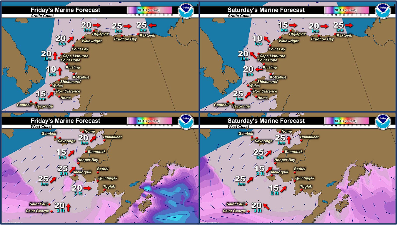
Synopsis Low pressure in the eastern Gulf of Alaska persists through Friday. High pressure moves from the western Bering to the eastern Bering through late week. Thursday through Saturday, a warm front pushes northward through the western/central Bering Sea.
Near St. Lawrence Island
Shorefast ice exists on the north, east, and south sides of the island. Between Gambell and Savoonga, shorefast ice has grown, extending up to 16 miles (25 km) to the northeast of Gambell but only 3 miles (4.8 km) to the north of Savoonga. Between Ataakas Camp and Alngeeyak, up to 12 miles (19 km) offshore. Beyond the shorefast ice along the north side of the island, compact pack ice exists consisting of vast to giant floes. Along the south side of the island, shorefast generally runs 2 to 3 miles (3 to 5 km) offshore. Beyond the shorefast ice on the south side is new to young ice from a recently frozen polynya. Any older/thicker floes are off the east/west sides of the island.
Nome
This area has not yet begun for the 2022 season.
Nome port entrance webcam (via AOOS webpage): https://bering-sea.portal.aoos.org/?ls=79875242-e362-65cb-914e-fed20ff9…
Brevig Mission/Port Clarence Area
This area has not yet begun for the 2022 season.
Wales to Shishmaref
Shorefast ice extends 28 miles (45 km) to the north of Wales, and 18 miles (29 km) to the north of Shishmaref. Beyond the shorefast ice is very close pack ice to consolidated ice with big to giant floes.
Diomede
Shorefast ice exists between the islands and extends to both the north and south 6 miles (9.6 km) from a centerpoint between Big/Little Diomede. Beyond the shorefast ice, as well as west/east of the islands, close to very close pack ice exists with big to vast floes. While some older/thicker floes are around the east and southeast side of the island, the ice to the southeast is predominately young ice from a previous polynya.
Forecast Discussion
Ice Forecast
Ice will generally move northward over the next week as some southerly winds impact the area. For St. Lawrence Island, a polynya could open off of the northern shorefast ice. For the south side of the island, young ice will be compacted against the shorefast ice. For Diomede, expect the young ice to the southeast to come back to the waters between Diomede and Wales, while thicker/older floes remain to the west. For Shishmaref, while brief, the southerly winds could break off some shorefast ice but it should remain largely intact.


Wind Synopsis
Southeast winds 15 knots (17 mph) Friday become southwest to 25 knots (29 mph) through the day Friday with gusts as high as 30 knots (35 mph), strongest near St. Lawrence Island. The southwest winds gradually wane Saturday night to 20 knots (23 mph) then 15 knots (17 mph) Sunday, then 10 knots (11 mph) Sunday night.
On Monday, the wind direction changes and winds increase to east-northeast 15 to 25 knots (17 to 29 mph) with gusts to near 30 knots (35 mph) Monday afternoon and evening. Tuesday through Thursday, east winds persist and weaken slightly to 10 to 15 knots (11 to 17 mph). On Friday, east winds increase again to 15 to 20 knots (17 to 23 mph).
Temperature Trend
On Friday, high temperatures will be in the upper teens above zero, and lows in the low to mid-teens. Saturday, temps warm to around 30 to 32 degrees for high temps, and lows in the low 20s. Sunday, highs will be in the upper 20s to low 30s and lows around the low 20s. Monday through Friday, temps stabilize around highs in the low to mid 20s, and lows in the mid-teens.
Daily Weather, Wind, and Temperature Updates
The National Weather Service provides twice-daily, text only updates on the weather, wind, and temperature conditions in specific geographical zones. An interactive weather map for access to other Alaskan zones can be found here: http://weather.gov/anchorage/ice
Higher resolution satellite images and wind maps (wind updated daily) can be viewed here: http://www.weather.gov/afg/SIWO_overview
The Alaska Ocean Observing System shares a variety of weather and sea ice related resources in their Bering Sea Portal at https://bering-sea.portal.aoos.org/.
Marine forecast for the West Coast and Arctic Coast
Remote Sensing Images


Observations and Comments
Observations of Sea Ice Development
Observations from Savoonga
7 April 2022 – Aqef Waghiyi
Nobody went hunting or got anything. There’s quite a few that brought their hunting gear down to whaling camp though. We’re gonna go hunt for whales pretty soon.
Observations from Gambell
8 April 2022 – Clarence Irrigoo, Jr.
Ice is moving in, south 8 mph 3°.


Observations from Wales
8 April 2022 – Robert Tokeinna, Jr.
This week was colder but less windy than last week. Average temperatures in the minuses to upper teens while brisk 30 mph to calm winds mostly out of the Northeast while Westerly winds yesterday and waking up to calm south winds today. I did notice a handful of snowbirds and it's suppose to warm up at the beginning of next week. There are signs of spring to come. Looking at the ocean today, I noticed open leads and pack flow ice while the edge of the ice seems to remain strong holding up. Local water hole continues to overflow and freeze with the below zero weather and upper teen weather trending this week.


Additional Comments Provided by Local Experts and Other Contributors
Visit the SIWO Facebook page @seaiceforwalrus to view this animation showing the predicted movement of ice predicted by the HYbrid Coordinate Ocean Model (HYCOM). Snapshots from the forecast show ice coverage from 0% (black) to 100% (white) and arrows show the relative speed and direction of the ice. A light boundary is drawn at 15% predicted ice cover to highlight the ice edge, but ice may be predicted to extend beyond it. Some bays, lagoons, and areas very close to shore are not covered by the model. (Image produced by the Alaska Ocean Observing System / Axiom Data Science)
