
Assessment of Current Ice Conditions Relevant to Distribution and Access of Walrus
Near St. Lawrence Island
The shorefast ice along the northern coastline of the island continues to be limited in extent, currently extending up to 8 miles offshore, while the shorefast ice along the southern coastline is limited to the lagoons. To the west, north, and east of the island lies a region of very close pack ice consisting of mainly first year ice floes. A small polynya is currently located along the west coastline of the island just south of Gambell extending up to 3 nautical miles offshore. To the south of the island beyond the lagoons lies a very large polynya extending up to 70 miles to the south that has frozen over with new and young sea ice.
Wales to Shishmaref
Shorefast ice along the northwest Seward Peninsula beyond the lagoons does not appear to be quite as stable this year as some years in the recent past. The edge of the shorefast ice currently extends 13 miles off the coast from Mugisitokiwik, 13 miles from Ikpek, and is limited to the extent of the lagoons near Shishmaref. Sea ice continues to be mobile through the Bering Strait with close pack ice consisting of first year ice floes. Compact pack ice lies off the coast from Shishmaref to Kotzebue Sound.
5 to 10 Day Forecast
Weather System/Wind Synopsis
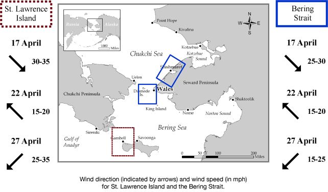
On Friday the 17th of April, a low-pressure system will be situated well south of Dutch Harbor. Winds across the area will be from the north at 20 to 30 kt (25 to 35 mph). The low will slowly work to near Cold Bay Saturday the 18th with winds remaining from the north at 20 to 30 kt (25 to 35mph). The low will swing into Bristol Bay Sunday, 19 April, with winds increasing to 30 to 40 kt (35 to 45 mph) from the northwest. The low quickly swings to near St. Lawrence Island Monday, 20 April, with winds become east-southeast at 10 to 20 kt (15 to 25 mph) by Monday night. The low remains in the Northern Bering Sea through Wednesday the 22nd before dying off by Thursday the 23rd. The winds will remain from the southeast Tuesday and Wednesday (21-22 April) at 10 to 15 kt (15 to 20 mph). On Thursday the 23rd, a low moves into Bristol Bay with winds turning northeast and increasing to 15 to 20 kt (20 to 25 mph). The low moves closer to St. Lawrence Island on Friday the 24th with north winds of 20 to 30 kt (25 to 35 mph). The low continues to swing past St. Lawrence Island on Saturday and Sunday (25-26 April) with winds becoming south 10 to 15 kt (15 to 20 mph). By Monday the 27th, another low moves into the Southern Bering Sea creating northeast winds of 10 to 20 kt (15 to 25 mph) near the Bering Strait and 20 to 30 kt (25 to 35 mph) near St. Lawrence Island.
Temperature Trend & Ice Forecast
Temperatures will be slightly below normal with daytime temperatures around 10 degrees Friday the 17th. After Friday, daytime temperatures in the mid 20s to mid 30s will be present. Overnight temperatures of 5 below to near 5 above are anticipated through Saturday morning. After that, overnight temperatures will warm into the 20s.
During the period of northerly to northwesterly wind flow Friday to Sunday (17-19 April) we expect that sea ice will continue to compact along the northern coastline of St. Lawrence Island with the polynya along the south and west facing coastline expanding. During this time the ice pack will compact along the shorefast ice edge from Wales to Shishmaref and ice floes near Wales along the Bering Strait may shift south into the northern Bering Sea.
Tuesday and Wednesday (21-22 April) the lighter southeasterly flow is expected to slowly fill in the polynya along the southern coastline of the island, and a narrow polynya may form along the shorefast ice edge from Wales to near Shishmaref. As winds become northeasterly to northerly on Thursday and Friday, the ice will once again compact along the shorefast ice edge from Wales to Shishmaref, and the polynya along the southern coast of St. Lawrence will expand. Lighter southerly flow on 25-26 April will slowly fill in the polynya along the southern coastline of St. Lawrence. As northeasterly wind flow returns on Monday the 27th we expect the polynya along the southern coastline of St. Lawrence Island to expand once again, with the ice compacting along the coast from Wales to Shishmaref as well.
Marine forecast for the West Coast and Arctic Coast
Remote Sensing Images


Observations and Comments
Observations of Sea Ice Development
Observations from Gambell
22 April 2015 - Merlin Koonooka
These past several days we have seen quite a lot of new snow with light winds blanketing the land and ice. When this happens, the people and hunters say in Yupik "Alliighighaa," which means a new soft layer of snow is laid on the ice for the newborns (walrus and the many species of seal) during their nursing period.
17 April 2015 - Merle Apassingok
There are larger ice floes coming in, but there has been mostly young ice forming over the past couple of weeks. The lack of winds and the currents have affected the opening west of Gambell. In the past 3-4 days areas west of Gambell have started to open up. The ice floes seen are thicker—not the multiyear ice from the past but still thick with good integrity.
Observations from Nome
20 April 2015 - Fred Tocktoo
Over the weekend, we saw some shorefast ice break off near Nome where some crab pots were located especially on towards the southwestern shore line, a couple of miles from Nome town. It won't be too long for the shorefast ice to break off in Nome.