
Assessment of Current Ice Conditions Relevant to Distribution and Access of Walrus
Near St. Lawrence Island
The shorefast ice along the northern coastline of the island continues to be limited in extent currently extending up to 8 miles offshore, while the shorefast ice along the southern coastline is limited to the lagoons. Beyond the shorefast ice edge to the north and east of the island lies a region of very close pack ice consisting mainly of first year ice floes. To the south of the island beyond the lagoons and along the west facing coastline lies a very large polynya that has some new and young sea ice forming within it.
Wales to Shishmaref
The shorefast ice along the coast from Shishmaref up to Kotzebue Sound is limited to the barrier islands at this time. A region of consolidated first year ice has formed in the past month along the coast from Wales to Shishmaref extending up to 14 miles beyond the barrier islands. Beyond the consolidated pack lies a region of close to very close pack ice consisting mainly of first year ice floes. It is notable that the ice floes in the vicinity of the Bering Strait continue to be very mobile this winter ice season.
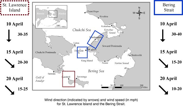
5 to 10 Day Forecast
Weather System/Wind Synopsis
On Friday, 10 April, a low-pressure system will be situated over mainland Alaska. Winds across the area will be from the northwest at 20 to 30 kt (25 to 35 mph). The low will remain over the mainland through the weekend with northwest winds decreasing to 5 to 15 kt (10 to 20 mph). The area of low pressure over the mainland dissipates as another low moves into the Gulf of Alaska by Wednesday, 15 April. Northwest winds pick back up to 10 to 25 kt (15 to 30 mph) on Wednesday. This low will wrap inland Thursday the 16th, with northwest winds diminishing to 10 to 15 kt (15 to 20 mph). The low remains over the mainland through Friday, 17 April, with no change in wind speeds. The low moves into the Kuskokwim Bay area with winds switching to the northeast at 10 to 20 kt (15 to 25 mph) on Saturday the 18th. The winds switch back to the northwest at 10 to 20 kt (15 to 25 mph) for Sunday and Monday, 19-20 April, as another low strengthens in the Gulf of Alaska.
Temperature Trend & Ice Forecast
Temperatures will be slightly below normal with daytime temperatures of 10 to 20 degrees and overnight temperatures of 5 below to near 10 above through Tuesday, 14 April. Temperatures warm up a bit for the remainder of the period to overnight lows of 10 to 20 degrees and daytime temperatures in the 20s and possibly reaching freezing (32 degrees) over the following weekend, 17-20 April.
With the winds over the Bering Strait and St. Lawrence Island region persisting out of the northwest through much of this period, we expect that much of the ice north of St. Lawrence Island will compact along the western coastlines. Meanwhile, the polynya along the south coast of the island will likely expand to the south and east during this time. The extent of the polynya southwest of the island will be impacted by ice moving out of the Gulf of Anadyr. Along the Wales to Shishmaref coast the compact ice beyond the barrier islands could become more solid during the period of northwest winds.
Marine forecast for the West Coast and Arctic Coast
Remote Sensing Images


Observations and Comments
Observations of Sea Ice Development
Observations from Wales
13 April 2015 - Winton Weyapuk, Jr.
Today we have extensive, ridged pack ice moving slowly north with a weak current. There are a few ponds and small leads covered with thin new ice. Bowhead and beluga whales have been seen in the leads and ponds the past few days. No walrus have been seen as of yet.