By: Lawrence C. Hamilton, University of New Hampshire; Cecilia M. Bitz, University of Washington; Edward Blanchard-Wrigglesworth, University of Washington; Matthew Cutler, University of New Hampshire; Jennifer Kay, National Center for Atmospheric Research; Walt Meier, National Aeronautics and Space Administration; Julienne Stroeve, National Snow and Ice Data Center; and Helen Wiggins, Arctic Research Consortium of the U.S.
Arctic sea ice follows an annual cycle, reaching its low point in September each year. The extent of sea ice remaining at this low point has been trending downwards for decades as the Arctic warms. Around the long-term downward trend, however, there is significant variation in the minimum extent from one year to the next. Accurate forecasts of yearly conditions would have great value to Arctic residents, shipping companies, and other stakeholders and are the subject of much current research. Since 2008 the Sea Ice Outlook (SIO) organized by the Study of Environmental Arctic Change (SEARCH) has invited predictions of the September Arctic sea ice minimum extent, which are contributed from the Arctic research community. Individual predictions, based on a variety of approaches, are solicited in three cycles each year in early June, July, and August. (SEARCH 2013).
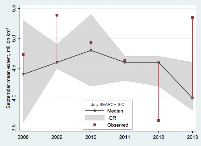
In a recent study done by our team, data from six years of past SIO predictions were compiled and analyzed for overall success in predicting the actual observed minimum ice extent. The analysis revealed that in some years the predictions were very successful. In other years, however, they were not. The years 2008, 2010, and 2011 were relatively easy to predict. Late-summer sea ice followed its long-term downward trend and scientific predictions of September extent averaged out close to the true final values. The years 2009, 2012, and 2013 proved more difficult. Sea ice extent made abrupt one-year excursions above or below its trend, which the predictions often missed. These findings are detailed in our paper, "Predicting September sea ice: Ensemble skill of the SEARCH Sea Ice Outlook," published in Geophysical Research Letters (Stroeve et al. 2014).
The main analysis in our study involved more than 300 predictions and comparisons of those predictions with the observed September ice extent. Figure 1 graphs the median (50th percentile) and interquartile range (25th to 75th percentile) of July SIO predictions. Red lines mark the distance from median predictions to the observed September mean extent. Median SIO predictions are close to the observed ice extent in 2008, 2010, and 2011. In 2009, 2012, and 2013, on the other hand, the median predictions are off by a large margin. June and August SIO predictions followed similar patterns.

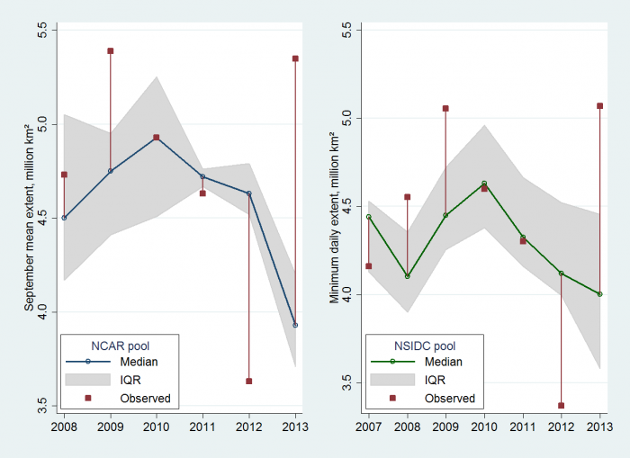
Two less formal sets of predictions also show this pattern. Since 2008, workers at the National Center for Atmospheric Research (NCAR) have conducted their own early-summer competition to guess the September mean sea ice extent. Losers buy ice cream for the winners. Because this pool is conducted for fun but also engages researchers, the competition could be described as well-informed though not strictly scientific. The left-hand plot in Figure 2 graphs median and interquartile range of 15 to 26 NCAR pool predictions each year. Again, red lines mark distance from median predictions to the observed September extent. This graph repeats the pattern of Figure 1. Median NCAR guesses fall close to the observed September extent in 2008, 2010, and 2011, but far from the observed values in 2009, 2012 and 2013.

The right-hand plot in Figure 2 depicts another informal but well-informed office competition, this one from the National Snow and Ice Data Center (NSIDC). In early summer, the first to third week of July, employees make guesses about the minimum daily ice extent, which is a slightly lower number than the monthly mean extent targeted by SIO and NCAR. Personnel at NSIDC closely follow sea ice conditions and their office calculates the widely used extent statistics. The NSIDC competition includes scientists directly involved with this research, but other colleagues, family, and friends can participate as well. The NSIDC graph summarizes 17 to 61 predictions each year, beginning in 2007. Again we see a familiar pattern: the median predictions are far from observed values in 2009, 2012, and 2013, but closer in other years.
The informal NCAR and NSIDC data agree with our SIO finding that a wide variety of prediction approaches collectively succeed in certain years, but fail in others. The well-predicted years turn out to be those in which sea ice extent lies close to its long-term downward trend. The difficult-to-predict years occur with abrupt variations above (2009, 2013) or below (2012) this overall trend. The trend reflects climate change, well established by many kinds of data. Variations around that trend at least partly reflect weather events, such as summer temperatures and wind conditions, which are much harder to forecast. However, new research incorporating additional information, such as the fraction of ice covered by melt ponds in the spring, shows promise for improved future predictions (Schroder et al. 2014).

On 1-2 April 2014, the [Sea Ice Prediction Network (SIPN)—a research effort jointly supported by the NSF, Office of Naval Research, National Oceanic and Atmospheric Administration, National Aeronautics and Space Administration, and Department of Energy—organized a workshop on Sea Ice Prediction. More than 50 international scientists gathered in Boulder, Colorado to discuss the state of the art and ways forward. The meta-analysis of past sea ice predictions described above highlights the challenge remaining as sea ice prediction looks beyond the multi-year downward trend, driven by climate, and focuses on season-to-season variations where weather plays a large role. The SIPN website will post news and information about this initiative.
References
SEARCH (Study of Environmental Arctic Change). 2013. Sea Ice Outlook. http://www.arcus.org/search-program/seaiceoutlook accessed 4/3/2014.
SIPN (Sea Ice Prediction Network). 2014. Networking scientists and stakeholders to improve sea ice prediction in a changing Arctic. http://www.arcus.org/sipn accessed 4/5/2014.
Schroder, D., D.L. Feltham, D. Flocco and M. Tsamados. 2014. "September Arctic sea-ice minimum predicted by spring melt-pond fraction." Nature Climate Change. doi: 10.1038/NCLIMATE2203.
Stroeve, J., L.C. Hamilton, C.M. Bitz, E. Blanchard-Wrigglesworth. 2014. "Predicting September sea ice: Ensemble skill of the SEARCH Sea Ice Outlook." Geophysical Research Letters. doi: 10.1002/2014GL059388.

