By: Donald A. Walker, Alaska Geobotany Center, Institute of Arctic Biology, and Department of Biology and Wildlife, University of Alaska Fairbanks
Introduction
Nearly 50% of the Arctic has ice-rich permafrost with large amounts of excess ground ice (up to 80% by volume), mainly represented by large ice wedges and lenses of segregated ice (Kanevskiy et al. 2022). Melting of the top surfaces of ice-wedges is altering the distribution of water, plant communities, and key ecosystem processes and making the ground unstable to build on across ice-rich parts of the Arctic (Liljedahl et al. 2016). The NSF Navigating the New Arctic project, titled "Landscape Evolution and Adapting to Change in Ice-Rich Permafrost Systems (NNA-IRPS)" (NSF Award No. 1928237) seeks to develop a broader understanding of how Arctic landscapes and ecosystems are evolving under the combined influence of climate change and local sources of disturbance.
The NSF Navigating the New Arctic Ice-Rich Permafrost Systems (NNA-IRPS) NIRPO Team
Donald A. Walker (PI): Alaska Geobotany Center, Institute of Arctic Biology, and Department of Biology and Wildlife, University of Alaska Fairbanks
Helena Bergstedt: Institute of Northern Engineering, University of Alaska Fairbanks, and B.geos GmbH, Korneburg, Austria
Amy L. Breen: Alaska Geobotany Center, Institute of Arctic Biology, and International Arctic Research Center, University of Alaska Fairbanks
Ronnie Daanen: Alaska Division of Geological and Geophysical Surveys, Fairbanks, Alaska
Olivia Hobgood: Alaska Geobotany Center, Institute of Arctic Biology, and Department of Biology and Wildlife, University of Alaska Fairbanks
Benjamin M. Jones: Water and Environmental Research Center, Institute of Northern Engineering, University of Alaska Fairbanks
M. Torre Jorgenson: Alaska Ecoscience, Fairbanks, Alaska
Anja Kade: Alaska Geobotany Center, Institute of Arctic Biology and Department of Biology and Wildlife, University of Alaska Fairbanks
Mikhail Kanevskiy: Institute of Northern Engineering, University of Alaska Fairbanks
Anna Kučerova: Alaska Geobotany Center, Institute of Arctic Biology and Department of Biology and Wildlife, University of Alaska Fairbanks, and Department of Biology, Masaryk University, Brno, Czech Republic
Anna K. Liljidahl (co-PI): Woods Hole Research Center, Falmouth, Massachusetts
Elias Manos: Department of Natural Resources and the Environment, University of Connecticut
Dimitry Nicolsky: Permafrost Laboratory, Geophysical Institute, University of Alaska Fairbanks
Jana L. Peirce: Alaska Geobotany Center, Institute of Arctic Biology, University of Alaska Fairbanks
Martha K. Raynolds: Alaska Geobotany Center, Institute of Arctic Biology, University of Alaska Fairbanks
Vladimir E. Romanovsky (co-PI): Permafrost Laboratory, Geophysical Institute, University of Alaska Fairbanks
Sergei Rybakov: Department of Geosciences, University of Alaska Fairbanks
Yuri Shur (co-PI): Institute of Northern Engineering, University of Alaska Fairbanks
Emily Watson-Cook: Alaska Geobotany Center, Institute of Arctic Biology, and Department of Biology and Wildlife, University of Alaska Fairbanks
Chandi Witharana: Department of Natural resources and the Environment, University of Connecticut
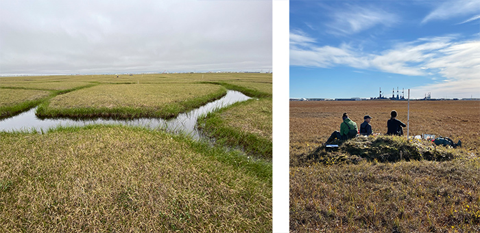
The project team established three ice-rich permafrost observatories to study ground-ice conditions in relation to surficial geology, vegetation, other geoecological features, and disturbances. The Roadside Ice-Rich Permafrost Observatory (RIRPO) and the Natural Ice-Rich Permafrost Observatory (NIRPO) are in the Prudhoe Bay Oilfield. The RIRPO was established in 2014–15 to examine road-related impacts. The NIRPO, established in 2021–2022 and described here, is relatively isolated from infrastructure to focus on climate-related changes (Figure 1). A Village Ice-Rich Permafrost Observatory at Point Lay, Alaska was the topic of another Witness the Arctic article (See: Infrastructure and Permafrost Degradation in Point Lay, Alaska.)
The project is using ground-based and remote sensing approaches to measure and monitor changes to ground temperatures, thaw depths, protective layers above the ice-wedges, surface landforms, hydrology, snow distribution, vegetation structure and composition, and greenhouse-gas fluxes.
Roadside areas in the RIRPO have changed from their pre-oilfield status due to a combination of a warmer climate, ice-wedge degradation, altered snow and drainage patterns, road dust, and other roadside disturbances (Kanevskiy et al. 2022; Walker et al. 2022). The new NIRPO site seeks to answer the question of what has happened in areas of the oilfield that are mainly affected by climate change in the absence of infrastructure.
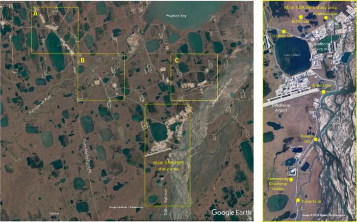
The Prudhoe Bay oilfield (Figure 2a) has terrain that is similar to extensive, flat, ice-rich landscapes found elsewhere on the Arctic Coastal Plain but with some rather unique aspects, including well-drained sites with nutrient-rich, prairie-like (Mollisol) soils, marl-bottomed ponds and lakes, and species-rich calciphilous plant communities and fauna. These aspects are associated with the ancient carbonate-rich gravelly floodplain deposits, which underlie most of the region. These deposits are derived from limestone bedrock in the Brooks Range and are topped by loess and organic-rich sediments.
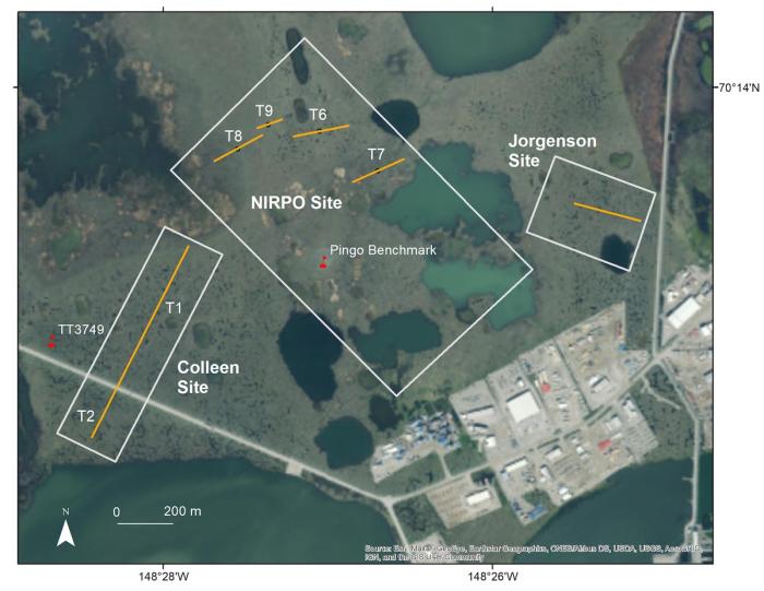
The main NNA-IRPS research areas (Figure 2b) are near the Deadhorse service area, which includes lodging, logistic-support facilities, and the Deadhorse Airport. The NIRPO site (Figure 3) has surficial geology and surface landforms typical of the local thaw-lake-plain landscapes, including: (1) thaw lakes; (2) recently "drained thaw-lake basins" with flat featureless surfaces; (3) older "ice-rich thaw-lake basins" with low-centered polygons and a small 4 m tall pingo; and (4) gravelly "alluvial plain deposits" with no apparent history of thaw lakes that are covered by 2–3 m of silt and organic deposits, ice-rich flat- and high-centered polygons, and abundant small thermokarst ponds (Figure 1a). The site is relatively isolated from infrastructure-related impacts, so changes to the vegetation and landforms at the NIRPO site are mainly those associated with climate change. The site thus provides comparisons with the heavily disturbed Lake Colleen and Airport sites (Figure 2b).
Samples of NIRPO Research
Numerous transects and permanent plots were surveyed to study the permafrost, vegetation, depths of summer soil thaw, snow conditions, and trace-gas fluxes in areas with different surficial geology deposits. Much of the initial research at the NIRPO site focused on thermokarst ponds (e.g., Figure 1a) and the effects of vegetation on the protective layer of soil and vegetation above ice-wedges in these ponds. An additional new focus is using the existing maps and knowledge in the Prudhoe Bay region to aid in computer-assisted automated recognition of ice-wedge polygons, water bodies, and infrastructure features.
Permafrost
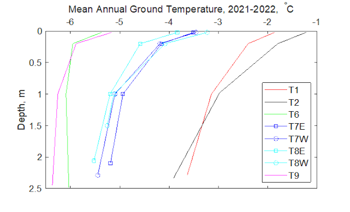
In 2021, four transects T6, T7, T8 (all 200 m long), and T9 (100 m long; Figure 3) were established on surfaces with different thaw-lake histories, parent materials, stages of ice-wedge evolution, polygon geomorphology, soils, and vegetation. Dmitry Nicolsky is monitoring near surface permafrost-temperatures at each of the NIRPO transects (T6–T9) and the Colleen transects (T1 and T2) at four depths (ground surface, -0.5 m, -1.0 m, and the bottom of the borehole, which vary between 1.5 and 2.5 m deep; Figure 2b). The mean annual ground temperature profiles show patterns that are related to the different surficial geology and disturbance regimes (Figure 4). The disturbed roadsides have the warmest temperature and the greatest change in temperature with depth. The residual surfaces are unaffected by thaw-lake processes and have the coldest temperatures with relatively small changes in temperature with depth. The drained lake basins have intermediate surface temperatures.
Mikhail Kanevskiy and colleagues drilled nearly 300 shallow permafrost boreholes along the transects at the Jorgenson, NIRPO, Colleen, and Airport research sites between 2011 and 2022. Their main objective was to examine the status of permafrost protective layers above ice wedges in polygon troughs and thermokarst ponds (Jorgenson et al. 2015, Kanevskiy et al. 2017, 2022). The data obtained to date show that degradation and stabilization of ice wedges are occurring within the same areas simultaneously. Some formerly stable ice wedges have experienced degradation with formation of new ponds, but most of the ice wedges that were actively degrading in 2011–2015 have experienced recent stabilization detected by thicker, ice-rich protective layers above the ice wedges. This is probably partially due to a recent summer cooling trend. The most significant stabilization occurred in deep thermokarst ponds, where fast development of aquatic vegetation has resulted in lower pond-bottom temperatures, thinner active-layers, and formation of thicker protective layers above partially degraded ice wedges (Kanevskiy et al. 2022, Watson-Cook 2022).
Vegetation
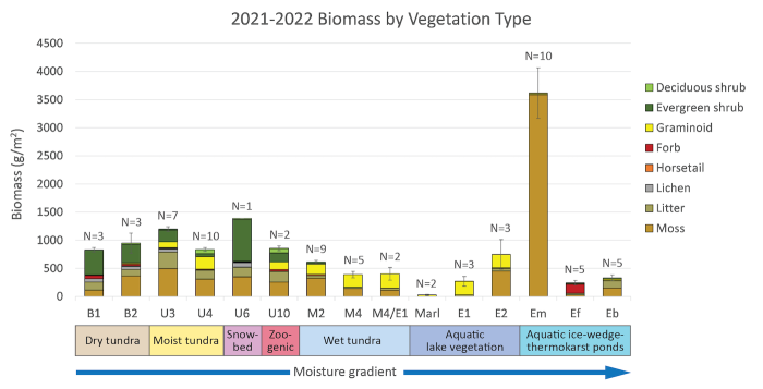
Much of the difference in permafrost temperatures is due to variations in the protective layer of vegetation. Ninety-four permanent vegetation plots were surveyed at the NIRPO and Jorgenson sites in 2021 and 2022. These plots complement 59 disturbed roadside plots that were surveyed at the Colleen and Airport sites in 2014–2015. Plant species cover and environmental data from these plots are being used by Olivia Hobgood for her MS thesis research to develop vegetation analysis of the species and environmental trends, including soil temperatures, across the site-moisture and landscape-age gradients at the NIRPO site, and for comparison with vegetation studies conducted in the 1970s (Walker 1985). Olivia and Emily Watson-Cook, who studied the vegetation in the thermokarst ponds, measured above-ground plant biomass on 75 selected plots along the NIRPO site-moisture gradient (Figure 5). The biomass varied from a mean of 25 g/m2 in marl-bottomed lake plots with sparse sedge (Carex aquatilis) communities to 3,617 g/m2 in aquatic moss (Calliergon richardsonii) communities in the thermokarst ponds. The extraordinary high biomass in thermokarst ponds is comparable to that found in shrublands further south but is not found elsewhere in the local Prudhoe Bay plant communities and is major factor in cooling pond-bottom temperatures and stabilizing ice-wedge degradation in the ponds (Watson-Cook 2022).
Snow
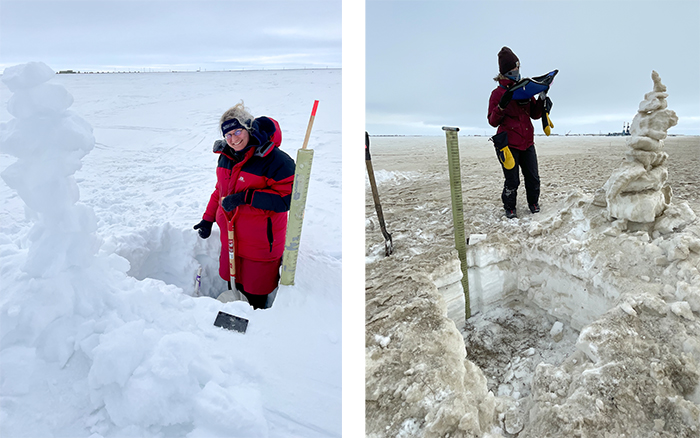
Deep snow insulates the ground surface during the winter resulting in warmer winter ground- surface temperatures. Snow depths were measured on the permanent vegetation plots by Amy Breen and colleagues during 28 April–3 May 2022. This was coordinated with a high-spatial-resolution LiDAR-based snow-surface topography survey conducted using a helicopter on 10 May 2022 by Ronald Daanen of the Alaska Division or Geologic and Geophysical Surveys. A snow-depth map was made by subtracting the ground-surface elevations, obtained from a 2021 LiDAR ground-surface topography survey, from the snow-surface elevations. Snow was generally much deeper in ice-wedge-polygon troughs and thermokarst pits, compared to polygon centers and featureless areas with no patterned ground. Deeper snow also occurred in snow drifts around pingos, and adjacent to roads and elevated pipelines.
The NIRPO site has relatively clean white snow because of its distance from roads, while the Colleen snow is strongly influenced by road dust (Figure 6). Helena Bergstedt used Sentinel satellite data to examine the effect of dust on the timing of snowmelt (Bergstedt et al. 2022). Areas near gravel roads with heavy traffic were snow-free at least at least one-to-two weeks earlier than areas remote from roads. This study highlighted the impact of infrastructure on large areas beyond the direct human footprint and the interconnectedness between snow-off timing, vegetation, surface hydrology, and near-surface ground temperatures.
Greenhouse Gas Fluxes
Changes in the distribution of water are having impacts to the flux of greenhouse gases to the atmosphere. Fluxes of greenhouse gases were previously measured in degraded ice-wedge polygon troughs in varying states of degradation/stabilization at the Jorgenson site (Wickland et al. 2020). Anja Kade is studying seasonal (summer and winter) variation in fluxes across the site-moisture gradient and on different-aged landscapes (Figure 7).
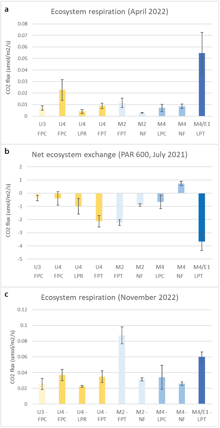
In late winter/early spring 2022, low levels of ecosystem respiration were measured in all plots across the soil moisture gradient as expected due to cold soils and snow cover (Figure 7).
However, relatively high respiration occurred in subsiding low-centered polygon trough plots (LPT) with transitional aquatic vegetation (Veg Type M4/E1; Figure 7a, dark blue bar). In summer, these same ice-wedge polygon troughs (U4, FPT; M2, FPT; and M4/E1, LPT) show relatively high negative CO2 flux (Figure 7b), indicating that the troughs are fixing relatively high amounts of carbon compared to polygon centers or featureless wet areas in recently drained thaw-lake basins. Early winter (November 2022; Figure 7c) fluxes had similar patterns to the late winter fluxes but an order of magnitude greater, likely because of relatively warm soils in fall compared to late winter.
Automated Recognition of Ice-Wedge Polygons, Water Bodies, and Infrastructure
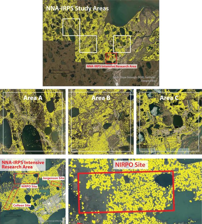
Artificial intelligence software developed at the University of Connecticut (Witharana et al. 2020) is using deep-learning pattern recognition, fusion of multispectral and very high spatial resolution panchromatic satellite imagery, and large super computers to identify and map a variety of Arctic features for the whole circumpolar Arctic. The time-series of integrated geo-ecological historical disturbance maps of Areas A, B, and C (Figure 2a) and the NNA-IRPS intensive research area offer manually identified sets of terrain and infrastructure features to help train automated recognition of these features in areas with similar Arctic terrain. The software is being utilized by the Permafrost Discovery Gateway, hosted by the Arctic Data Center to make this information available through the internet, (Anna Liljedahl, PI. NNA Award # 1927723). Maxar imagery was used to help the AI software recognize ice-wedge polygons (Figure 8) in the Prudhoe Bay Oilfield. Early results indicate that the Permafrost Discovery Gateway software is able to detect most ice-wedge polygons in this landscape where polygons and ice-wedges can be verified on the excellent air-photo and remote sensing images of the area. An analysis of the accuracy of prediction is still needed across the various landscape units with differing concentrations and types of ice-wedge polygons.
Conclusion
The NIRPO site adds a relatively isolated research area to several existing long-term research sites in the Prudhoe Bay Oilfield. Integrated permafrost, vegetation, soil, trace-gas flux, snow, remote sensing and modeling studies along transects and permanent plots are contributing new knowledge regarding how this ice-rich permafrost landscape formed and how the mainly climate-driven changes at this site compare to the sites that are affected by the cumulative effects of climate- and infrastructure-related changes.
Further information is found on the NNA-IRPS Project flyer, the Project Summary, Related Publications 2019–2022, the NIRPR project webpage, the Arctic Data Center's Ice-rich Permafrost Systems webpage, and the related project page on the University of Alaska Fairbanks, Alaska Geobotany Center website. For questions, please use the project contact form.
References
Bergstedt, H., B. M. Jones, D. A. Walker, J. L. Peirce, A. Bartsch, G. Pointner, M. Z. Kanevskiy, M. K. Raynolds, and M. Buchhorn. 2022. The Spatial and Temporal Influence of Infrastructure and Road Dust on Seasonal Snowmelt, Vegetation Productivity, and Early Season Surface Water Cover in the Prudhoe Bay Oilfield. Arctic Science. https://doi.org/10.1139/as-2022-0013.
Jorgenson, M. T., M. Kanevskiy, Y. Shur, N. Moskalenko, D. R. N. Brown, K. Wickland, R. Striegl, and J. Koch. 2015. Role of Ground Ice Dynamics and Ecological Feedbacks in Recent Ice Wedge Degradation and Stabilization. Journal of Geophysical Research: Earth Surface 120: 2280–2297. https://doi.org/10.1002/2015JF003602.
Kanevskiy, M., Y. Shur, T. Jorgenson, D. R. N. Brown, N. Moskalenko, J. Brown, D. A. Walker, M. K. Raynolds, and M. Buchhorn. 2017. Degradation and Stabilization of Ice Wedges: Implications for Assessing Risk of Thermokarst in Northern Alaska. Geomorphology 297: 20–42. https://doi.org/10.1016/j.geomorph.2017.09.001.
Kanevskiy, M., Y. Shur, D. A. (Skip) Walker, T. Jorgenson, M. K. Raynolds, J. L. Peirce, B. M. Jones, and M. Buchhorn. 2022. The Shifting Mosaic of Ice-Wedge Degradation and Stabilization in Response to Infrastructure and Climate Change, Prudhoe Bay Oilfield, Alaska, USA. Arctic Science. https://doi.org/10.1139/as-2021-0024.
Liljedahl, A. K., J. Boike, R. P. Daanen, A. N. Fedorov, G. V. Frost, G. Grosse, L. D. Hinzman, Y. Iijma, J. C. Jorgenson, N. Matveyeva, M. Necsoiu, M. K. Raynolds, V. E. Romanovsky, J. Schulla, K. D. Tape, D. A. Walker, C. J. Wilson, H. Yabuki, and D. Zona. 2016. Pan-Arctic Ice-Wedge Degradation in Warming Permafrost and its Influence on Tundra Hydrology. Nature Geoscience 9: 312–318. https://doi.org/10.1038/NGEO2674.
Raynolds, M. K., D. A. Walker, K. J. Ambrosius, J. Brown, K. R. Everett, M. Kanevskiy, G. P. Kofinas, V. E. Romanovsky, Y. Shur, and P. J. Webber. 2013. Cumulative Geoecological Effects of 62 Years of Infrastructure and Climate Change in Ice-Rich Permafrost Landscapes, Prudhoe Bay Oilfield, Alaska. Global Change Biology 20: 1211–1224. http://doi.wiley.com/10.1111/gcb.12500.
Walker, D. A. 1985. Vegetation and Environmental Gradients of the Prudhoe Bay Region, Alaska, CRREL Report 85–14. Hanover, NH: U.S. Army Cold Regions Research and Engineering Laboratory. http://hdl.handle.net/11681/9420.
Walker, D. A., M. K. Raynolds, M. Z. Kanevskiy, Y. S. Shur, V. E. Romanovsky, B. M. Jones, M. Buchhorn, M. T. Jorgenson, J. Šibík, A. L. Breen, A. Kade, E. Watson-Cook, G. Matyshak, H. Bergstedt, A. K. Liljedahl, R. P. Daanen, B. Connor, D. Nicolsky, and J. L. Peirce. 2022. Cumulative Impacts of a Gravel Road and Climate Change in an Ice-Wedge-Polygon Landscape, Prudhoe Bay, Alaska. Arctic Science 8: 1040–1056. https://doi.org/10.1139/as-2021-0014.
Watson-Cook. 2022. Thermokarst-Pond Plant Community Characteristics and Effects on Ice- Wedge Degradation in the Prudhoe Bay region, Alaska. M.S. thesis, University of Alaska Fairbanks. 84 pp. https://www.proquest.com/pagepdf/2760847139?accountid=14470.
Wickland, K. P., M. T. Jorgenson, J. C. Koch, M. Kanevskiy, and R. G. Striegl. 2020. Carbon Dioxide and Methane Flux in a Dynamic Arctic Tundra Landscape: Decadal-Scale Impacts of Ice Wedge Degradation and Stabilization. Geophysical Research Letters 47:e2020GL089894. https://doi.org/10.1029/2020GL089894.
Witharana, C., M. A. E. Bhuiyan, A. K. Liljedahl, M. Kanevskiy, H. E. Epstein, B. M. Jones, R. Daanen, C. G. Griffin, K. Kent, and M. K. W. Jones. 2020. Understanding the Synergies of Deep Learning and Data Fusion of Multispectral and Panchromatic High Resolution Commercial Satellite Imagery for Automated Ice-Wedge Polygon Detection. ISPRS Journal of Photogrammetry and Remote Sensing 170: 174–191. https://doi.org/10.1016/j.isprsjprs.2020.10.010.
About the Author
 Donald A. "Skip" Walker is a professor of biology at the University of Alaska Fairbanks Institute of Arctic Biology and Director of the Alaska Geobotany Center. His research interests include, environmental biology; disturbance and recovery of Arctic ecosystems; global tundra ecosystems; hierarchical geographical information systems; landscape ecology; landscape response to climate change; and quantitative ecology methods.

