
Assessment of Current Ice Conditions Relevant to Distribution and Access of Walrus
Click the name of each community below to view more frequently updated and detailed information from the National Weather Service.
Synopsis: A low strengthens in the southwestern Bering Sea and moves north towards the ice edge on Thursday. This area of low pressure will linger and weaken, southeast of St. Lawrence Island, through Saturday then weaken and move inland for the weekend. Low pressure moves into the western high Arctic on Sunday.
Near St. Lawrence Island
Open water has continued to expand outward from the island’s northwestern, western, and southern coastlines. Open water reaches outward to 120 miles (193 km) north of Savoonga, and outward to the Russian border north and west from Gambell. A band of very open pack ice (previously shorefast ice breaking up) extends southwest from near Silook Camp up to 45 miles (72 km). Shorefast ice east of Savoonga remains from Camp Iveetok through Camp Kulowiye up to 2 miles (3.2 km) from the coast. Shorefast from the east side through the south side of the island remains from Camp Kulowiye to Kialegak Point and outward up to 2 miles (3.2km). Very close pack of first year medium ice with small to vast floes exists from just east of Savoonga through the east side of the island, north to 75 miles (120 km) north of Camp Kulowiye.
Nome
Shorefast ice extends up to 0.6 miles (1 km) offshore along the Nome coast, with the exception of up to 7 miles (11 km) offshore near Sledge Island. Beyond the shorefast ice near Nome is an area of open pack ice that extends up to 50 mi (80 km) from the shorefast ice. Beyond the shorefast ice between Nome and Golovin Bay is close to very close pack ice.
Nome port entrance webcam (via AOOS webpage): https://bering-sea.portal.aoos.org/?ls=79875242-e362-65cb-914e-fed20ff9…
Brevig Mission/Port Clarence Area
The outlook for this area has not yet begun for the season.
Wales to Shishmaref
Shorefast ice primarily remains within the lagoons. Close to very close pack ice lies from Shishmaref coast outward to 20 miles (32 km) northwest of Shishmaref and along the coast to Ikpek. Beyond the close to very close pack ice lies an area of open pack ice. This area extends northwest from Wales to Shishmaref up to 100 miles (160 km). East of Shishmaref, close to very close pack ice extends up to 45 miles (72 km) offshore with open to close pack ice beyond that.
Diomede
Shorefast ice remains between Big and Little Diomede with 7.4 miles (11.9 km) of north/south extent. Close pack ice extends from 8 miles (13 km) northeast of Diomede to 95 miles (153 km) north of Diomede as well as an area 4.5 miles (7.2 km) east of Diomede extending south to St. Lawrence Island. Elsewhere around Diomede is very open pack ice to open water eastward up to 8 miles (12.8 km) and westward up to 19 miles (30 km). Very open pack ice extends from the close pack ice on the eastern side and outward from there to Wales. Close pack ice exists of first year medium ice consisting of small to big floes.
Forecast Discussion
Ice Forecast
For St. Lawrence Island, northerly winds through Saturday will continue to push the ice pack into the northeast coastline of the island. Medium floes are possible within the open water on the northwest and west sides of the island. Winds then become light and variable, allowing sea ice to continue to move with tides and currents.
For the Nome area coastline, sea ice will generally drift westward through Saturday, then south to southeastward Sunday through Thursday.
For Diomede, sea ice will drift south to southeast through early Tuesday, then begin to drift northward through Thursday.
For Wales to Shishmaref, sea ice will generally move with the local tides and currents through Saturday, then drift toward the Wales to Shishmaref coastline through Tuesday. Some northward drift is expected Wednesday and Thursday, and a polynya may form between Wales and Shishmaref.


Wind Synopsis
Winds will increase on Friday, 26 May with north to northeast winds of 13 to 22 knots (15 to 25 mph) from Shishmaref to St. Lawrence Island and east to southeast winds of 4 to 9 knots (5 to 10 mph) at Nome. Winds diminish to 9 to 17 knots (10 to 20 mph) by Saturday, 27 May from Diomede to St Lawrence Island, while at Shishmaref, winds will become variable 6 knots or less (7 mph or less). On Sunday, 28 May winds will begin to shift to the west across the area and increase to 10 to 15 knots (11 to 17 mph) on Monday, persisting through Friday, 2 June.
Temperature Trend
High temperatures will stay in the lower to mid-30s through the week, except at Nome where temperatures will peak in the low to mid-40s. Low temperatures will stay in the low to mid-30s, except at Shishmaref, where low temperatures will stay in the upper 20s to lower 30s.
Daily Weather, Wind, and Temperature Updates
The National Weather Service provides twice-daily, text only updates on the weather, wind, and temperature conditions in specific geographical zones. An interactive weather map for access to other Alaskan zones can be found here: http://weather.gov/anchorage/ice
Higher resolution satellite images and wind maps (wind updated daily) can be viewed here: http://www.weather.gov/afg/SIWO_overview
The Alaska Ocean Observing System shares a variety of weather and sea ice related resources in their Bering Sea Portal at https://bering-sea.portal.aoos.org/.
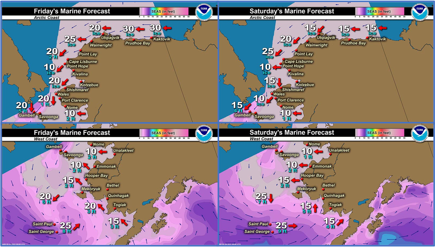
Marine forecast for the West Coast and Arctic Coast
Remote Sensing Images


Observations and Comments
Observations of Sea Ice Development
Observations from Gambell
Friday, 26 May 2023 – Clarence Irrigoo, Jr.
Few boats went out on Monday nobody went out because of high winds and rain and fog.

[Editor's note: we asked Clarence for the St. Lawrence Island Yupik word for the mirage effect in this photo. It is Qaghma. Igamsi, Clarence!]
8:20 p.m. Update
Some boats went out getting bearded seal, could hear their shots.
Observations from Diomede
Friday, 26 May 2023 – Marty Eeleengayouq Ozenna
North side of the island is closed in with some fog and north wind also opened in the middle of the island and the south side is completely open.

Observations from Port Clarence, Brevig Mission, and Cape Douglas
Friday, 26 May 2023 – Marcus Barr
Current ice conditions: a lot of water on top of the ice, nobody hunting yet.
Observations from Savoonga
Friday, 26 May 2023 – Aqef Waghiyi
It’s raining pretty good. Snow is melting pretty fast this morning. 31 deg F. pressure is 994. Humidity is 100%. No wind or real light breeze. Wind keeps shifting. Earlier this week people went boating and got walrus and seal.
Observations from Wales
Friday, 26 May 2023 – Robert Tokeinna, Jr.
For the past couple of weeks, the sea ice had made big changes and more recently, the shorefast broke off 10 miles north of Wales thru the grapevines. I finally went on the hillside, but forgot my phone at home for updated pictures. The water was open as far as I know to the Diomede Islands with flow ice here and there. Birds and ducks have made their way around Wales with spring in full swing. Snow melting, water puddling, and birds chirping with a very slow warm up here in Wales. The weather today is a balmy 30 plus degrees, breezy winds out of the north at 20 mph, and overcast skies with rain today. I can see that this will be the trend for Wales for the next couple of days as warm fronts hit Wales area. Updated pictures will be sent later on once I take them.
Additional Comments Provided by Local Experts and Other Contributors
Shared by the Alaska Ocean Observing System (AOOS) for 24 May–1 June 2023
Visit the SIWO Facebook page @seaiceforwalrus to view this animation showing the predicted movement of ice predicted by the HYbrid Coordinate Ocean Model (HYCOM). Snapshots from the forecast show ice coverage from 0% (black) to 100% (white) and arrows show the relative speed and direction of the ice. A light boundary is drawn at 15% predicted ice cover to highlight the ice edge, but ice may be predicted to extend beyond it. Some bays, lagoons, and areas very close to shore are not covered by the model. (Image produced by the Alaska Ocean Observing System / Axiom Data Science).
