
Assessment of Current Ice Conditions Relevant to Distribution and Access of Walrus
Click the name of each community below to view more frequently updated and detailed information from the National Weather Service.
Synopsis Weak and broad low pressure remains over the Gulf of Alaska, extending into the Bering Sea and Mainland Alaska. Friday and Saturday, several low-pressure systems will traverse east Asia into the Chukchi Peninsula and eventually the Bering Strait on Sunday, then the eastern Beaufort Sea on Monday. High pressure builds into the southern Bering Sea by the middle of next week while another weak low pressure traverses the Bering Strait. Overall, expect weak systems to track from the Chukchi Peninsula across the Bering Strait onto the mainland.
Near St. Lawrence Island
Shorefast ice is mainly on the north side of the island. Shorefast ice does not extend much offshore Gambell/Savoonga, around 1/2 mile (.8 km), but does extend 1 to 3 miles (1.6–4.8 km) between the two locations. To the north and northeast of Gambell is open pack ice consisting of strips and small to medium floes. Areas of close pack ice with medium to big floes exist within the more open pack ice area. Closer to Savoonga, northerly wind flow has compacted and consolidated ice against the shorefast. It is hard to differentiate the shorefast ice with the consolidated/compact ice. The compact ice extends off of the shorefast of Savoonga 8 miles (13 km). Between Savoonga and Camp Kulowiye, shorefast ice extends 2–8 miles offshore (3.2–12.8 km). Compact/consolidated ice extends an additional 12 to 22 miles (18 to 35 km) to the northeast from the shorefast ice. Beyond the compaction is close pack ice consisting of medium to vast floes. The compacted ice is streaming around the east side of the island. Beyond that ice is open water, around 22 miles from the shore (35 km). Other than the stream of pack ice from east of the island, the south side of the island is open water with a large polynya that extends 50 to 100 miles (80 to 160 km). Off the east side of the island is very open pack ice with small to medium floes.
Nome
Shorefast ice in the area looks to be decaying quickly, though some does exist near Port Safety to around 0.5 miles (0.8 km) offshore. Between the two locations it looks mostly gone/eroded. It also remains intact to the west of Nome up to 2 miles (3.2 km) offshore. Otherwise, open water to very open pack ice exists consisting of small floes.
Nome port entrance webcam (via AOOS webpage): https://bering-sea.portal.aoos.org/?ls=79875242-e362-65cb-914e-fed20ff9…
Brevig Mission/Port Clarence Area
Shorefast ice remains intact 27 miles (43 km) to the west of Port Clarence and 22 miles to the south of Port Clarence (35 km). There is a large polynya that extends 8 to 12 miles (12.8 to 19 km) off the shorefast ice. It consists of very open pack ice with small floes with an area of close pack ice to the south of Port Clarence with small to medium floes. Beyond the polynya is close pack ice, some new ice mixed with first year ice and medium to large floes.
Wales to Shishmaref
Shorefast ice extends 30 miles (48 km) to the north of Wales, and 18 miles (29 km) to the north of Shishmaref. Between Wales and Shishmaref, beyond the shorefast, there is very close pack ice to consolidated ice, consisting of small to big floes. There is a polynya to the south and southeast of Wales that is mostly open water to very open pack ice with small floes.
Diomede
Shorefast ice between the islands remains intact, extending south around 6 miles (9.6 km). Around the islands is very close pack ice consisting of medium to vast floes. South of Wales is a polynya that extends to the southeast.
Forecast Discussion
Ice Forecast
On Friday, moderate southerly wind flow will bring a big change to the region. The region of biggest change will be the ice to the north of St. Lawrence Island. The winds will likely push off the recently compacted ice, and potentially could take some shorefast ice with it. Some pack ice could again approach the southern side of the island as the polynya closes as well. For Diomede, pack ice will flow back toward the islands, as well as the polynya closer to the mainland should move back through the Bering Strait. For Wales to Shishmaref, the polynya off the shorefast ice should open up again; there’s a better chance closer to Shishmaref and toward Espenberg. The southerly winds will help melt the open pack ice near Nome, as well as continue to erode the remaining shorefast ice. As the winds briefly flip back from the north, look for the polynyas to close on north-facing shores, but this should be short-lived as southerly winds are expected to return next week.


Wind Synopsis
North winds of 10 to 15 kts (12 to 17 mph) Friday morning will become west to southwest by Friday night and increase to 15 to 20 kts (17 to 23 mph) by Saturday morning. On Sunday, stronger southwest winds of 20 to 25 kts (23 to 29 mph) develop between St. Lawrence Island and the southern Seward Peninsula, while winds elsewhere remain 10 to 20 kts (12 to 23 mph). By Monday morning, winds will switch to the northwest and increase to 20 to 25 kts (23 to 29 mph) from the Bering Strait south. Tuesday, winds switch around to the southwest and diminish to 10 to 15 kts (12 to 17 mph), except for the Bering Strait where winds will be 15 to 20 kts (17 to 23 mph) and will continue through Wednesday. On Thursday, winds shift to the north northwest and remain in the 10 to 15 kts (12 to 17 mph) range north of St. Lawrence Island through the Bering Strait, while east of St. Lawrence Island to the southern Seward Peninsula, winds will be from the southwest at 5 to 10 kts (6 to 12 mph).
Temperature Trend
From St. Lawrence Island to Brevig Mission/Port Clarence and north to Wales and Shishmaref, high temperatures will generally range in the low to mid 30s. Overnight lows in the mid to upper 20s expected for St. Lawrence Island, while overnight temperatures from Shishmaref to Wales will be cooler and in the upper teens to mid 20s. In the Brevig Mission/Port Clarence area, overnight lows will range from the lower 20s Friday night (the coolest night) to the mid 20s to lower 30s by Saturday night, continuing through the week. Along the southern Seward Peninsula near Nome, high temperatures will top out in the middle to upper 30s, with 40 not out of the question by Wednesday; overnight lows will range from the mid 20s Friday night to the lower to mid 30s by Saturday night, continuing through the week.
Daily Weather, Wind, and Temperature Updates
The National Weather Service provides twice-daily, text only updates on the weather, wind, and temperature conditions in specific geographical zones. An interactive weather map for access to other Alaskan zones can be found here: http://weather.gov/anchorage/ice
Higher resolution satellite images and wind maps (wind updated daily) can be viewed here: http://www.weather.gov/afg/SIWO_overview
The Alaska Ocean Observing System shares a variety of weather and sea ice related resources in their Bering Sea Portal at https://bering-sea.portal.aoos.org/.
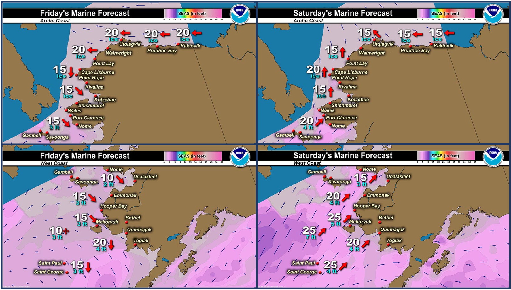
Marine forecast for the West Coast and Arctic Coast
Remote Sensing Images


Observations and Comments
Observations of Sea Ice Development
Observations from Savoonga
Thursday, 5 May 2022 – Aqef Waghiyi
Nobody has gone out boating since last week. Closed in. Can’t get to open water.Everybody’s ready to go when we get a chance to go. Hopefully we’ll get a chance to go out before all the ice disappears.
Observations from Diomede
Thursday, 5 May 2022 – Marty Eeleengayouq Ozenna
Good morning, today elevation 800 900 feet ceiling. North about 25–30 knots. Clear 12 plus miles north. Clear to the south about 8 to 12 plus miles. North side closed up and the south side is open. Also hoping today be a mail day an there a day behind due to weather


Observations from Port Clarence and Brevig Mission
Thursday, 5 May 2022 – Marcus Barr
Broke off to the beach at Cape Douglas. One local hunter brought his boat down to Douglas and got bearded seal. Another Teller local brought his also and didn't go boating yet.
UPDATE: Friday, 6 May 2022
Local hunters caught bearded seal after fast ice broke off to the Beach at Cape Douglas. More and more geese showing up and seals also on the ice near Port Clarence. Cracks are showing up more too.

Observations from Shishmaref
Friday, 6 May 2022 – Curtis Nayokpuk
Cold northerly winds past week combined with occasional fog and snow slowed the spring thaw in our area. Pending forecast southerly winds the loose pack ice looks solid along the shore fast ice from May 2nd. "Worldview" info. Hunters digging out boats in preparation and with cold nightly freezing conditions hunters will be hunting any open leads with snowmobiles during spring break up.

UPDATE: Light snow and mist (fog?) this Friday morning. No new satellite pictures yet, one from yesterday the 5th. to compare to May 2nd. shot show thru the fog the ice in southern Bering Strait melted or broke up in open sea wave action.

Observations from Gambell
Friday, 6 May 2022 – Clarence Irrigoo, Jr.
Boats that reach the ice got some walrus and bearded seals. Before we reach some ice walrus start to show up. Long time to find the ice, when we find the ice it was midnight got home at 3AM.


Observations from Wales
6 May 2022 – Robert Tokeinna, Jr.
Lot of movement on the ice, lost some pressure ridges and front portions of the outer shorefast ice. It's been northeast to north winds from calm to 30 mph and lower single digits to 20 to 25 degrees for these past two weeks. I am seeing more Sea gulls and snow birds with coming of the Cranes this week. With cool winds and cool temperatures, there's been little thawing, but it’s supposed to switch winds and get warm on Saturday. More to come soon.


Additional Comments Provided by Local Experts and Other Contributors
Visit the SIWO Facebook page @seaiceforwalrus to view this animation showing the predicted movement of ice predicted by the HYbrid Coordinate Ocean Model (HYCOM). Snapshots from the forecast show ice coverage from 0% (black) to 100% (white) and arrows show the relative speed and direction of the ice. A light boundary is drawn at 15% predicted ice cover to highlight the ice edge, but ice may be predicted to extend beyond it. Some bays, lagoons, and areas very close to shore are not covered by the model (Image produced by the Alaska Ocean Observing System / Axiom Data Science).
