
Assessment of Current Ice Conditions Relevant to Distribution and Access of Walrus
Click the name of each community below to view more frequently updated and detailed information from the National Weather Service.
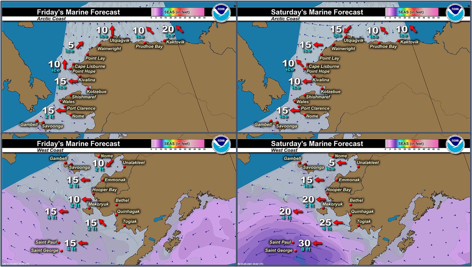
Synopsis – Several low pressure systems will move into the southeastern Bering Sea through Monday. High pressure will remain over the Chukchi Sea.
Near St. Lawrence Island
There is shorefast ice on the north, east, and south sides of St. Lawrence Island. On the north and south sides, generally extending 1 to 2 miles offshore, and on the east side, extending 2 to 5 miles offshore. Beyond the shorefast ice on the north and east sides of the island is close pack ice to consolidated ice consisting of medium to vast floes with the exception of an area of open water approximately 4 miles north of Savoonga and stretching 30 miles to the northeast.
There is a polynya south of the island that extends up to 32 miles south of Powooiliak (Pugughileq) Camp and 40 miles south of Siknik Training Camp. Beyond that polynya is close pack ice consisting of medium to vast floes. There is also a polynya off the west coast that stretches 5 miles west of Gambell and 12 miles west of Booshu Camp, with close pack ice consisting of medium to vast floes beyond that.
Nome
Shorefast ice around the Nome area extends up to 2 miles offshore from Sinuk to near Solomon, and up to 7 miles offshore near Cape Rodney out to Sledge Island. Beyond the shorefast ice from Port Safety west is very close pack ice consisting of medium to vast floes. East of Port Safety, there is a polynya that extends up to 16 miles offshore, with very close pack ice consisting of medium to vast floes beyond that.
Brevig Mission/Port Clarence Area
Shorefast ice extends 23 to 25 miles west/southwest of Brevig Mission. There is then a polynya that extends up to 16 miles beyond the shorefast ice, then the main pack ice is very close pack ice consisting of medium to giant floes.
Wales to Shishmaref
Shorefast ice extends up to 2.5 miles from the coast. Beyond the shorefast ice is very close pack ice to consolidated ice consisting of medium to giant floes. There is a small polynya between Mitletukeruk and Ikpek that extends about 3 miles beyond the shorefast ice.
Diomede
Shorefast ice persists between the islands. There is a polynya that extends up to 8 miles north of the shorefast ice. Otherwise, very close pack ice consisting of big to giant floes surrounds the island.
Forecast Discussion
Ice Forecast
Sea ice will generally move with the tides and currents through Friday, April 30th. There may be some slight southward movement Sunday evening, April 25th through Wednesday, April 28th. Thinner sea ice between thicker ice floes will continue to melt through the week.


Wind Synopsis
Light and variable winds 5 to 10 kt (6 to 11 mph) will persist across the Bering Strait region Friday, April 23rd through Sunday, April 25th. Winds will shift to the north 10 to 15 kt (11 to 17 mph) by Sunday evening and continue through Wednesday, April 28th. On Thursday, April 29th, winds will shift to a west-northwesterly direction 5 to 10 kt (6 to 11 mph) and persist through Friday, April 30th.
Temperature Trend
High temperatures Friday, April 23rd through Tuesday, April 27th will be mainly in the 30's except in the lower 40's around Nome. Overnight low temperatures will be in the 20's. Temperatures will cool down Wednesday, April 28th through Friday, April 30th with afternoon highs in the upper 20's to the 30's, with overnight low temperatures in the upper teens to upper 20s. Warmest temperatures will continue around Nome.
Daily Weather, Wind, and Temperature Updates
The National Weather Service provides twice-daily, text only updates on the weather, wind, and temperature conditions in specific geographical zones. An interactive weather map for access to other Alaskan zones can be found here: http://weather.gov/anchorage/ice
Higher resolution satellite images and wind maps (wind updated daily) can be viewed here: http://www.weather.gov/afg/SIWO_overview
Marine forecast for the West Coast and Arctic Coast
Remote Sensing Images


Observations and Comments
Observations of Sea Ice Development
Observations from Wales
20 April 2021 – Robert Tokeinna, Jr.
Much open water, sea ice seems to be holding off, signs of thawing. Seen sea gulls and some snow birds. Warm past day or two upper 20s to lower teens, brisk 20 mph with mid 30s today. Notice couple fishermen, unsure if they were successful. This was taken about 10 PM Monday. April 19, 2021.

Observations from Savoonga
22 April 2021 – Aqef Waghiyi
Everybody’s at south side, nobody hunting or boating on the north side. Open leads here and there. You can see walrus on the ice a couple miles north of town. Today in a while will go to the cliffs and send a couple of pictures. People are boating down south trying to get a whale. Murres, eiders, and seagulls are back.


Observations from Port Clarence and Brevig Mission
22 April 2021 – Marcus Barr
Cape Douglas sea ice report. Snow is melting along the coast. Still jumbled up ice going all the way out to the open water. Locals in Teller and Brevig saw geese arriving. My twin brother got a young bearded seal out near Port Clarence and couple Brevig guys got crab pots set near Douglas.


Observations from Nome
23 April 2021 – Boogles Johnson
This past week has been the real start of spring in Nome. Early in the week we had a day with winds reaching up to 40 knots from the north which pushed the ice out but as of today there are no apparent leads or the ice came back. The photo is from the old federal building in Nome and there's ice as far as you can see at this time. I have not heard of any hunters heading out yet but I know folks are getting their boats ready for the spring hunt!

Observations from Gambell
23 April 2021 – Clarence Irrigoo, Jr.
The photo of whaling is Capt. A. Aningayou, whale 41 ft. The ice went further out today, April 23. Going out at this time.


Observations from Diomede
24 April 2021 – Marty Eeleengayouq Ozenna
South side of us n south side of Russia, also a pic of the north still closed in but the past 3 days been pretty warm n melting the snow n ice.


Additional Comments Provided by Local Experts and Other Contributors
Shared by Rick Thoman, ACCAP
20 April 2021
There are effectively no clouds at all in this Tuesday afternoon satellite photo. The areas of open water/low concentration sea ice have increased in most areas since Monday, including eastern Norton Sound, offshore between Cape Nome and Cape Darby and Cape Woolley to Wales.
