
Assessment of Current Ice Conditions Relevant to Distribution and Access of Walrus
Click the name of each community below to view more frequently updated and detailed information from the National Weather Service.
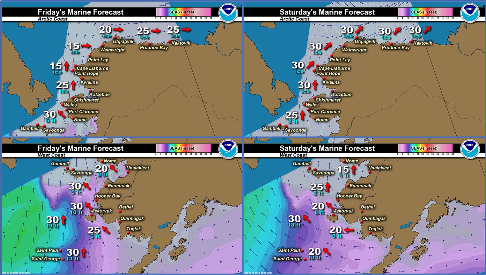
Forecast Synopsis for 28 March – 1 April 2019
Synopsis. High pressure will remain over much of mainland Alaska through Saturday. Low pressure near Kamchatka will keep much of the area under southerly flow.
Near St. Lawrence Island
Recent southerly flow has really changed the nature of ice around the island. Very little shorefast ice is left, mainly along the north side of the island, several pockets of discontinuous along the coast. The remainder of the ice off the north coast is very open pack ice with big floes. All along the southern coast, very close pack ice exists where the southerly flow has shoved ice against the shore. For the east, west, and south of the island, close pack ice exists with medium to big floes.
Nome
The ice around Nome does not appear to be shorefast anymore. Very close pack ice exists up to 1–2 nm offshore where open water exists. There hasn't been a real clear look in a couple days, but it is possible in continued southerly flow that more close pack ice exists. The pack ice is made up of ice cakes to medium floes less than one foot thick.
Wales to Shishmaref
The forecast has not yet begun for 2019 in this region. Please check back later for updates.
Little Diomede
The forecast has not yet begun for 2019 in this region. Please check back later for updates.
Forecast Discussion
Ice Forecast
For St. Lawrence Island: Warm southerly flow will continue through the period. Expect sea ice to continue to compact along the southern edge of the island. The remaining shorefast ice along north side of the island will be vulnerable to break off. The polynya, which is really very open pack ice, will continue to grow and will likely diminish to open water by the end of the period.
For Nome: Continued southerly flow will create compact pack ice along the coast, probably up to 2–3 nm off shore. Winds will lighten toward the first of next month, but with warmer temperatures and sea surface temperature, not much new growth is expected.

Wind Synopsis
On St. Lawrence Island, south winds 25 to 30 kt (29 mph to 35 mph) on Friday, March 29th will diminish to southeast around 15 kt (17 mph) Saturday, March 30th. Winds will be east to southeast 10-15 kt (11-17mph) Sunday, March 31st through Monday April, 1st. On Tuesday, April 2nd winds will become northeast 10-15 kt (11-17 mph) increasing to 15 to 20 kt (17 to 23 mph) on Wednesday, April 3rd. Winds northeast around 25 kt (30 mph) on Thursday, April 4th and continuing into Friday, April 5th
At Nome, southeast winds 15 to 20 kt (17 to 23 mph) on Friday, March 29th will diminish to south to southeast around 5 to 10 kt (6-11 mph) Saturday, March 30th. Winds will be east to southeast 5 to 10 kt (6-11 mph) Sunday, March 31st through Monday, April, 1st. On Tuesday, April 2nd winds will become east to northeast around 10 kt (11 mph). By Wednesday, April 3rd, east to northeast will increase to 10-15 kt (11-17 mph) and continue through Thursday, April 4th and Friday, April 5th.
Temperature Trend
High temperatures will generally be in the 30's Friday, March 29th through Friday, April, 5th with temperatures approaching 40 around Nome Friday, March 29th and Saturday, March 30th. Lows will mainly be in the 20s Friday, March 29th through Friday, April, 5th.
Daily Weather, Wind, and Temperature Updates
The National Weather Service provides twice-daily, text only updates on the weather, wind, and temperature conditions in specific geographical zones. An interactive weather map for access to other Alaskan zones can be found here: http://weather.gov/anchorage/ice
Wind maps are updated daily and can be viewed here: http://www.weather.gov/afg/SIWO_overview
Marine forecast for the West Coast and Arctic Coast
Remote Sensing Images


Observations and Comments
Observations of Sea Ice Development
Observations from Wales
28 March 2019 – Robert Tokeinna, Jr.
For the past two weeks, we've had our ice freeze last week to leaving this past weekend due to high surf. We've been hampered mostly South winds for the past week and before that Northerly winds. A lot of snow accumulations and for the past couple days with rainy, snowy conditions. As for sea ice, very little to no travel due to young ice conditions and warming weather. I heard of a reporting of a snow bird; and this morning, while taking my photos of the ice, I heard sea gulls. Temperatures have been as low as -20 °F to warm as 30°F with windy, snowy, rainy mixed. Lots of overcast skies and freezing fog which hampered my efforts to send an observation last week as Wales was intermittently in and out with internet and long distance.


Observations from Savoonga
28 March 2019 – Aqef Waghiyi
People went boating today and yesterday and got walrus five miles out. People are still out getting walrus. We have 20-25 kt wind from the south right now. Will find out more when the boats come up. Yesterday one of the airlines said there were lots of herds of walrus out there.
[video:]


Observations from Gambell
28 March 2019 – Clarence Irrigoo, Jr.
Lots of young ice showing up from the south with walrus. Today some boats are out probably with games. Photos taken from west beach.


Observations from Port Clarence and Brevig Mission
29 March 2019 – Marcus Barr
Broken up ice to the beach from strong southerly winds. Some ice piled up ¼ mile out. Main ice from Brevig to the ice edge is starting to show fewer snow on top from the warm weather we had for few days. With north wind and current going out the ice will go with it once it switches.


Observations from Nome
29 March 2019 – Boogles Johnson
There has been strong south winds lately pushing the ice back to the Nome coast. There was a slight formation of new ice last week but our warm temperatures have ceased all new ice formation. These current conditions make it extremely difficult and unsafe to go and hunt on the ocean at this time. I've spotted seals out on the ice but cannot go and hunt due to our weather and bad ice conditions.


Observations from Shishmaref
1 April 2019 – Curtis Nayokpuk
No ice to take pictures of, open sea out front. Thin jumbled up ice that formed during "rare" North wind broke off along shore line and went out with south winds gusting to 30+ MPH. Checking sat pics I see scattered ice edge was 30 miles out. A month ago, walrus were heard and seen passing (small groups both on ice and swimming) heading east to Kotz sound. Going to be tough finding any sea mammals this spring.