
Assessment of Current Ice Conditions Relevant to Distribution and Access of Walrus
Click the name of each community below to view more frequently updated and detailed information from the National Weather Service.
Near St. Lawrence Island
There is very open ice pack to the north and east of Savoonga with medium to vast floes. Otherwise open water surrounds St. Lawrence Island.
Nome
Shorefast ice extends up to 2 nm offshore from Nome, then 1 to 2 nm of very open pack ice with small to big floes. Beyond the very open pack ice is widespread very close pack ice with vast to giant floes.
Wales to Shishmaref
Shorefast ice extends up to 1.5 nm northwest of the coast from Wales to Shishmaref. Beyond the shorefast ice is 8 to 10 nm of very open pack ice, then very close pack ice with vast to giant floes beyond that.
Diomede
Open pack ice surrounds Diomede Island with medium to vast floes.
Forecast Discussion
Ice Forecast
Sea ice will drift southwestward through Wednesday, April 25th, then begin to move northward Thursday, April 26th and Friday, April 27th. The wind and wave action during this time is expected to cause more ice melting especially in the area between St. Lawrence Island and the Bering Strait.
Wind Synopsis
Expect moderate to strong northeast winds of 20 to 30 kt (23 to 35 mph) on Friday, April 20th, with the strongest winds along north of St. Lawrence Island. On Saturday, April 21st, northeast winds will diminish to 10 to 20 kt (12 to 23 mph) along the Bering Strait and southern Seward Peninsula. Winds remain in the 20 to 30 kt (23 to 35 mph) range near St. Lawrence Island. Northeast winds increase to 15 to 25 kt (17 to 29 mph) along the Bering Strait on Sunday, April 22nd. Winds remain in the 20 to 30 kt (23 to 35 mph) near St. Lawrence Island. On Monday, April 23rd, winds diminish to 15 to 25 kt (17 to 29 mph), with the strongest winds remaining north of St. Lawrence Island. Winds diminish to 10 to 15 kt (12 to 17 mph) and become north to northeast on Wednesday, April 25th. Winds shift around to the west southwest during the day Thursday, April 26th and increase to the 15 to 25 kt (17 to 29 mph) range by Friday, April 27th.
Temperature Trend
Friday and Saturday daytime highs will range from the lower 20s to the lower 30s. Warming trend ensues beginning Sunday, April 22nd with daytimes highs ranging from the mid 20s from Wales to Shishmaref to the lower 30s on St. Lawrence Island and to the low to mid 30s near Nome. Daytime high temperatures remain fairly steady Monday, April 23rd through Friday, April 27th with highs in the lower to mid 30s from Shishmaref west to St. Lawrence Island, and in the upper 30s to lower 40s near Nome.
Daily Weather, Wind, and Temperature Updates
The National Weather Service provides twice-daily, text only updates on the weather, wind, and temperature conditions in specific geographical zones. An interactive weather map for access to other Alaskan zones can be found here: http://weather.gov/anchorage/ice
Wind maps are updated daily and can be viewed here: http://www.weather.gov/afg/SIWO_overview
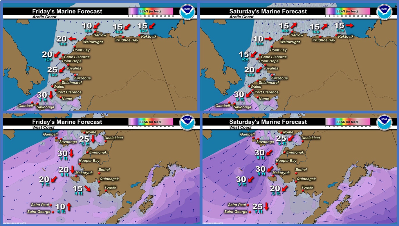
Marine forecast for the West Coast and Arctic Coast
Remote Sensing Images


Observations and Comments
Observations of Sea Ice Development
Observations from Diomede
19 April 2018 – Opik Ahkinga
Four days before this ocean was covered by connecting ice. Today we have less ice floe between the Diomede islands. One boat went out to hunt and brought back oogruk late in the night. I don’t think they went too far, broken ice is still drifting and passing around our islands. It’s only April, and we’ve already waves washing the beach. There has been some walrus floating on ice beyond Big and Little Diomede. A couple were seen earlier in the week drifting on moving ice between our islands.


Observations from Shishmaref
19 April 2018 – Curtis Nayokpuk
Trip out to ice edge measuring open seal holes show shore fast ice 12 in. from the beach to open sea 2 to 3 miles. No hunting yet with blowing snow a few days ago crews digging out boats today. Included in photo set are Gina (today) and Polar View (17 th.) to compare info online you can use to check on ice in respective areas.


UPDATE from Shishmaref
20 April 2018 – Curtis Nayokpuk
Northeast winds picking up this morning and forecast to be 15-25 mph with gust to 40. Looking at Polar View this morning confirmed ice edge breaking off due to waves along open sea. Traditional spring hunting is still a month away and crews will have to work together to venture out to remaining pack ice moving off shore and north with main current. Our "last resort" hunting in poor ice seasons has been to head east to hunt in Kotzebue Sound but the bay is looking to be ice free early as well.

Observations from Wales
19 April 2018 – Robert Tokeinna, Jr.
This week has been a warm and seems to be spring out as Wales seen drastic change with water all over the place. We have lost some more of the front pressure ridges and even the tip of our point. You can see quite a bit of water on the ice as you see in the picture. Temperatures range from upper 30s to current lower 20s, warm southerly winds to begin with going from northeast then to east winds currently. There is over flow in and around creeks and ponds with quite a bit on the shorefast ice.
The ice has been going in and out from time to time, but the shorefast ice is still intact. Hunters are not going out, maybe because of the flux of ice going in and out.


Observations from Brevig Mission / Point Clarence
17 April 2018 – Marcus Barr
Port Clarence Point, 11 miles SW of Brevig Mission. Ice conditions near the edge are not good-ice breaking off from current going out and northerly winds.


Observations from Nome
19 April 2018 – Boogles Johnson
My photos are not great, but today we are having some significant ice movement. You can see sheets of ice breaking off the shorefast ice by eye. The seal hunters in Nome are all gearing up and heading out if they have boats that can be pulled on the ice by snowmobile. The spring hunting season is in full swing with long warm sunny days bringing people outside to enjoy the sunshine. It's time to get the spring tan!


UPDATE from Nome
19 April 2018 – Boogles Johnson - 7:30 pm
Our ice in front of Nome just broke off this evening!


Observations from Savoonga
19 April 2018 – Aqef Waghiyi
People went out boating today and got walrus. Don’t know how much walrus they got yet. Maybe furthest was 14-20 miles out. Not much ice, north wind, waves coming from the north, white caps out there. Boats were coming up and most of the boats got in. Getting boat launches ready, plowing snow on the beach with heavy equipment.
(Aqef sent photos on SD card in the mail – we will add to his report as soon as they arrive)
Observations from Gambell
19 April 2018 – Clarence Irrigoo, Jr.
Two days ago boats got walrus NE of Gambell, little ice showing up from other side.

Additional Resource
19 April 2018 - Rick Thoman – National Weather Service
Satellite photo from Thursday afternoon. Not very much ice left in the Bering Sea, and with east winds, a lot of ice has pulled away from the northern Seward Peninsula coast and it looks like the shore fast ice is breaking off on the Chukotka coast. Photo from GINA at UAF.
Check out the Facebook group Seward Pen/Bering Straits Weather and Climate Info here: https://www.facebook.com/groups/631657950559392/
