
Assessment of Current Ice Conditions Relevant to Distribution and Access of Walrus
NEW FOR 2017: Click the name of each community below to view more frequently updated and detailed information from the National Weather Service.
Near St. Lawrence Island
Sea ice remains shorefast along the northeast coast of St. Lawrence Island up to 2 nautical miles from the coast. Very close pack ice extends from 1 to 6 nm beyond the shorefast ice. Shorefast ice is mostly gone from the northwest coast of the island, with very open pack ice extending up to 1 nm offshore. The east side of the island has very open pack ice extending up to 2 nm offshore. The south and west sides of the island are sea ice free.
Nome
The coastal waters around Nome consist mainly of open to very open pack ice extending 10 nm offshore, with open water beyond that. A vast flow of close pack ice is located 10 nm offshore to the southwest of Nome.
Wales to Shishmaref
Shorefast ice has shown rapid deterioration lately with new leads developing. Much of the previously analyzed shorefast ice looks more like very close pack ice or consolidated ice which extends 18 to 25 nm offshore, with open water beyond that. The extent of the shorefast ice looks to be generally 1-2 nm from shore with an area up to 5-7 nm closer to Wales.
Little Diomede
Little Diomede Island is now sea ice free on all sides.
Forecast Discussion
Ice Forecast
Near the Wales to Shishmaref coast, shorefast ice is expected to remain in place as very close pack ice sits to the northwest of the shorefast ice. The pack ice in the region will continue to move slowly to the southwest, but some open water will remain west of Wales. The offshore waters of the Bering Strait region will likely remain sea ice free for the season. For St. Lawrence Island, the highest concentration ice will remain on the northeast side of the island as the shorefast ice continues to weaken. The remaining ice on the northwest side of the island will likely melt out to sea ice free conditions in the next few days. Near Nome, the open pack ice in northern Norton Sound will continue to spread out and melt over the course of the next week. 
Wind Synopsis
Northeast winds will remain between 5 to 10 kt (10 to 15 mph) sustained from St. Lawrence Island to the Chukchi Sea coast through Saturday. Winds will shift to east on Sunday 10 to 15 kt (15 to 20 mph) over St. Lawrence Island while areas north of the Bering Strait will remain northeast at 5 to 10 kt (10 to 15 mph) through Tuesday before becoming east on Wednesday and Thursday. Winds will then transition back to north and increasing 10 to 15 kt (15 to 20 mph) by Friday for areas along St. Lawrence Island and north of the Bering Strait.
Temperature Trend
Low temperatures will remain in upper 20s to lower 30s with gradual warming trend to mid 30s by Wednesday then dropping back to lower 30s by Friday, May 26th. High temperatures will gradually warm from mid to upper 30s on Saturday up to lower 40s by early next week. Finally, a gradual cooling trend in high temperatures back to mid 30s by Thursday, May 25th.
Daily Weather, Wind, and Temperature Updates
The National Weather Service provides twice-daily, text only updates on the weather, wind, and temperature conditions in specific geographical zones. An interactive weather map for access to other Alaskan zones can be found here: http://weather.gov/anchorage/ice
Wind maps are updated daily and can be viewed here: http://www.weather.gov/afg/SIWO_overview
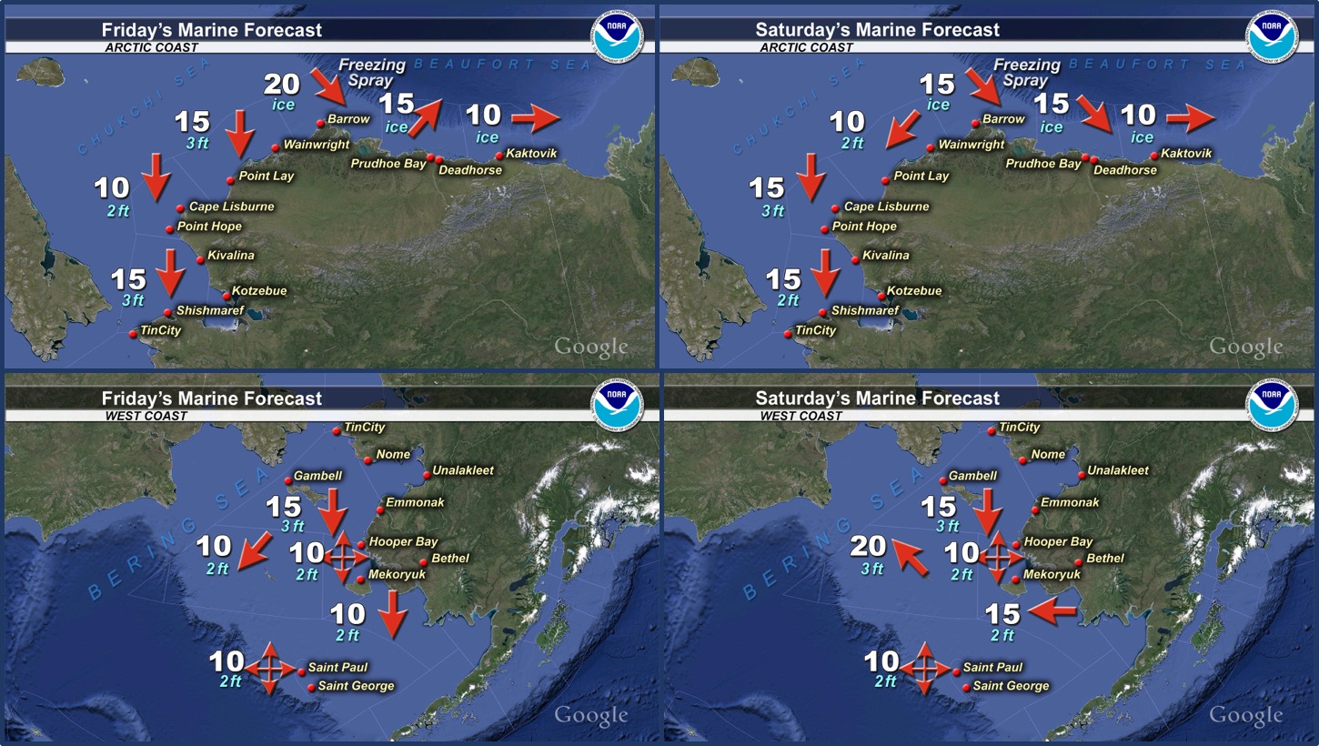
Marine forecast for the West Coast and Arctic Coast
Remote Sensing Images


Observations and Comments
Observations of Sea Ice Development
Observations from Wales
17 May 2017 – Robert Tokeinna, Jr.
This week for Wales sea ice observation, we started out with south winds but for the past 5 days breezy northerly west winds were prominent with south and east winds beginning this week. Ever since last week, the shorefast ice has been slowly coming off piece by piece. There are those tougher pressure ridges as you notice in the photo enclosed with this observation. I have seen more cranes and Snow Geese passing over the community. There was a polar bear sighting about a mile out of town by the local dumpsite, which the local polar bear patrollers were on high alert since then. It snowed a couple times to leave a trickle of snow but nothing alarming. A boat from Little Diomede means the sea is opened up between the two communities. The hunters of Diomede seen abundant amount of game coming over. School had their last day of school and awards assembly then students were dismissed for the summer break.
Observations from Gambell
17 May 2017 – Clarence Irrigoo, Jr.
The ice is gone in Gambell, but Clarence shares these photos of a foggy morning this past week. He also shares that "Some boats went to Savoonga area and caught some walrus."

19 May 2017 – James Walunga
There is no more ice which still should have been their till at least mid-June! Very poor hunting season. Stronger currents have been moving more ice to the east and there is now no more ice in the west side. Also, there is more brittle ice so these days there is less land ice since it also gets moved more easily with the current.
Observations from Shishmaref
19 May 2017 – Curtis Nayokpuk
Fog, snow and drizzle/rain late afternoons this past week and Shishmaref woke up to winter with 4 in. snow cover Wednesday morning the 17th. Latest Polar View shows shorefast ice to west breaking up and will be 15-18 mile boat haul to launch and hunt Bearded Seals and Walrus. Wind forecast with southerly winds, partly cloudy by Monday - Tuesday looks to be favorable conditions to be out hunting. Northerly winds kept last remaining ice pack moving north in the Kotzebue Sound area and will be a concentration of sea mammals from all the ice-free areas seen on Gina and Polar View pictures of the Bering Strait and Chukchi Sea. 
19 May 2017 (later in the day) – Curtis Nayokpuk
Travel West along beach line was smooth over snow covered 10-12 in. thick shore fast ice. Nearest open lead (20 mi. down coast) was a mile from beach line and encountered 3-4 in. snow covered thin ice areas to access water edge. White out conditions with fog moving in to reach water edge will have to wait till clear weather to find trail around thin ice to try and establish a boat launch. 


Observations from Nome
18 May 2017 – Boogles Johnson
See a clip from Boogles' video of a lone female walrus on our Facebook page here
Additional Comments Provided by Local Experts and Other Contributors
Update from NWS Alaska
Sea ice break up is well underway across the southern and eastern Chukchi Sea. While there is still some shorefast ice along the northern Seward Peninsula from Wales to Shishmaref and Espenberg as well as within Kotzebue Sound, we can see on satellite imagery that it is beginning to destabilize.
There is also a lead forming in the sea ice from near Espenberg to near Cape Krusenstern. This can result in a portion of the destabilized "close to very close" pack ice along the coast to break off at any time. Please use caution if you are planning to be on or near the sea ice in these areas.