
Assessment of Current Ice Conditions Relevant to Distribution and Access of Walrus
Near St. Lawrence Island
Sea ice conditions near St. Lawrence Island have changed quite a bit from last week. The shorefast ice along the northern coastline of the island continues to be limited in extent, currently extending up to 4.5 miles, while the shorefast ice along the southern coastline remains limited to the lagoons. Beyond the shorefast ice to the north of the island, there is a region of very close to close pack ice consisting of first year ice floes. To the east of the island close-pack ice is shifting in and out near the shoreline. The coastline from Gambell around to the west- and south-facing coasts of the island are open water, with isolated first year ice floes passing in a strip from the pack ice north of the island beyond the coastline near Gambell on to the southwest.
Wales to Shishmaref
Shorefast ice remains in place along the northwest Seward Peninsula. The shorefast ice edge extends roughly 13 miles off the coast from Mugisitokiwik, 13 miles from Ikpek, and 1.5 miles off the coast from Shishmaref. Beyond the shorefast ice edge from Shishmaref to the outside of Kotzebue Sound lies a region of close to very close pack ice consisting mainly of first year ice floes. Beyond the shorefast ice edge from Ikpek up to Shishmaref, there is a region of open to close pack ice consisting of first year ice floes with new and young sea ice filling in around the floes. The ice pack is currently very mobile through the Bering Strait near Wales with a large region roughly 12 miles offshore from Wales that is mainly new sea ice with isolated first year ice floes drifting through.
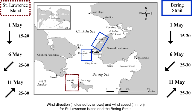
5 to 10 Day Forecast
Weather System/Wind Synopsis
High pressure will be over Eastern Russia Friday the 1st of May with north to northwest winds of 10 to 15 kt (15 to 20 mph). High pressure will remain over the area through the weekend. The high will shift into the Chukchi Sea Monday the 4th of May moving the winds to the northeast at 15 to 20 kt (20 to 25 mph). High pressure will remain over the Chukchi through Wednesday the 6th of May with northeast winds of 20 to 25 kt (25 to 30 mph). North winds will diminish and switch to the northwest at 10 to 15 kt (15 to 20 mph) on Thursday the 7th. Low pressure will enter the western Chukchi Sea Friday the 8th switching the winds to the southwest at 10 to 15 kt (15 to 20 mph). The low will remain in the Chukchi Sea through Sunday the 10th with southwest winds of 15 to 20 kt (20 to 25 mph). On Monday the 11th of May, a low-pressure system will swing out of the Gulf of Anadyr and into the Bering Strait increasing winds from the southwest at 20 to 25 kt (25 to 30 mph).
Temperature Trend & Ice Forecast
Temperatures will be 5 to 10 degrees above normal with daytime temperatures around 30 to 40 degrees. Overnight temperatures of 20 to 30 degrees are anticipated, except around Kotzebue Sound where temperatures will be in the teens this weekend.
Since the majority of the wind direction will be of a northerly direction during the week, we expect that sea ice will continue to compact along the northern coastline of St. Lawrence Island with the polynya and open waters south and west of the coastline expanding. During this time, the shorefast ice edge from Wales to Shishmaref and ice floes near Wales along the Bering Strait will shift out into the Bering Strait and south into the northern Bering Sea. During the weekend of the 9th through the 11th of May, the winds will be southwest moving ice north through the Bering Strait and possibly moving shorefast ice off the north coast of St. Lawrence Island and destabilizing the shorefast ice from Wales to Shishmaref. Independent ice floes will push to the southern coast of St. Lawrence Island next weekend as well.
Marine forecast for the West Coast and Arctic Coast
Remote Sensing Images


Observations and Comments
Observations of Sea Ice Development
Observations from Nome
1 May 2015 - Fred Tocktoo
Nome's got a gradual, normal-type spring with intervals of warm temps, above 40 for just a few days. River systems are beginning to run off but slowly for now. Shorefast ice has been slowly melting and hasn't shown too many break-offs yet. No breakup of shore ice yet and folks are getting ready for spring hunt along the coast in search for open water.
Observations from Wales
30 April 2015 - Amos Oxereok
The pressure ridges are not as high this year, and there are many more low spots between them. I wouldn’t be surprised if our shore ice doesn’t make it all the way to June this year. Looking through binoculars, I’ve noticed a lot more chunks of high ice floating by this year. There also is a lot more open water as the pack ice is further off shore right now. The waves are breaking out there right now and I can see swells near the horizon.
30 April 2015 - Winton Weyapuk, Jr.
10:00 A.M. Skies are overcast, wind NE at 15, temperature 23 F, visibility 10 miles. There is a wide lead with dark water sky.
29 April 2015 - Winton Weyapuk, Jr.
9:10 A.M. Skies are overcast, wind NE at 15, temperature 21 F, visibility 10 miles. There are white caps in the open water to the south. One whaling captain said it is too windy to go hunting today.
28 April 2015 - Winton Weyapuk, Jr.
9:25 A.M. Skies are clear, wind NE at 15, temperature 19 F, visibility 32 miles. There is a wide lead with a corner 8 miles north of Wales. The captain of the crew that went hunting yesterday said it was very nice 8 miles north at the corner of the lead. He said the water was rough for part of the way on the way up.