
Assessment of Current Ice Conditions Relevant to Distribution and Access of Walrus
Click the name of each community below to view more frequently updated and detailed information from the National Weather Service.
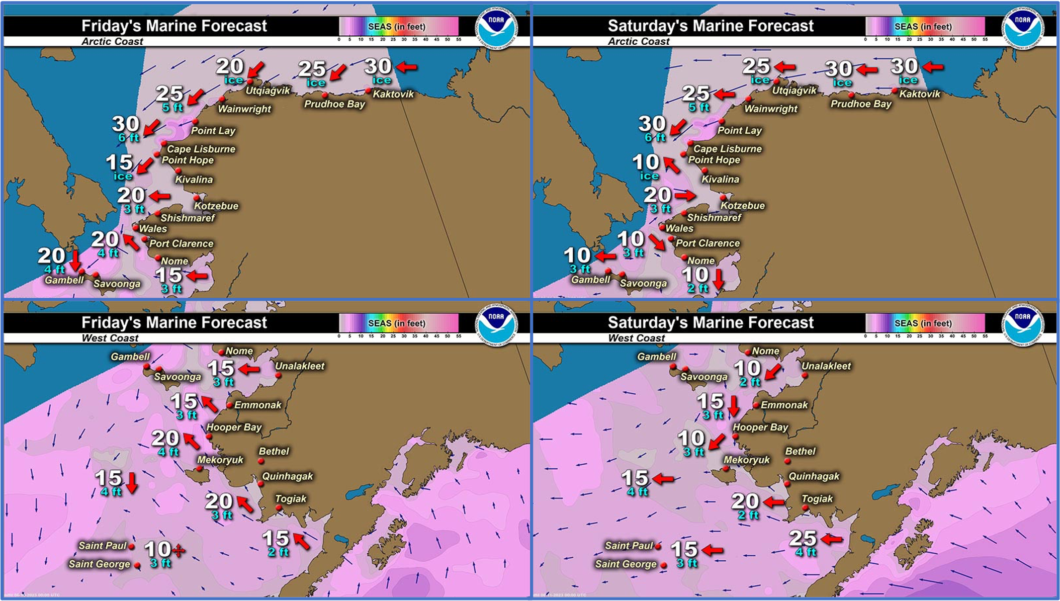
Synopsis: A broad region of low pressure will remain in the south and central Bering Sea through the weekend. High pressure will build over the northern Chukchi Sea and high Arctic. These two features will bring easterly and northerly winds over the ice pack and ice edge.
Near St. Lawrence Island
The remaining sea ice around St. Lawrence Island is from east of Camp Iveetok and around the east side of the island. A large area of close pack ice consisting of small to big floes extends northeast from near Lietnik to Camp Kulowiye. This area of ice extends toward the Bering Strait and toward the outer part of Norton Sound. An area of open to close pack ice consisting of small to medium floes extends southeast from the east coast of the island up to 45 miles (72 km).
Nome
Sea ice is quickly spreading out as it melts in northwestern Norton Sound. There is an area of open pack ice consisting of small to medium floes that extends 7 miles (11 km) south of Nome. And area of open water beyond that extends to about 40 miles (64 km) south of Nome. Another area of open pack ice consisting of small to medium floes extends from east of Nome toward the southwest and southeast 50 to 60 miles (80 to 97 km).
Nome port entrance webcam (via AOOS webpage): https://bering-sea.portal.aoos.org/?ls=79875242-e362-65cb-914e-fed20ff9…
Brevig Mission/Port Clarence Area
The previously shorefast ice in the Port Clarence and Brevig Mission area extends 22 miles (35 km) southwest of Brevig Mission. An area of very open pack ice consisting of small to big floes extends another 10 miles (16 km) west of that previously shorefast ice, and a large area of close pack ice consisting of medium to vast floes extends another 22 miles (35 km) southwest from the area of open pack ice.
Wales to Shishmaref
The main area of sea ice is very close to consolidated pack ice that extends from near Ikpek to Espenberg, with open water beyond that. This area of sea ice extends up to 15 miles (24 km) from the Wales to Espenberg coastline and consists of medium to vast floes. There is also an area of open to close pack ice west of Wales, that extends from 8 miles (13 km) south of Diomede and 15 miles (24 km) west of Wales to south to St. Lawrence Island. This area of sea ice consists of small to big floes.
Diomede
The main area of open to close pack ice extends from 8 miles (13 km) south of Diomede and 15 miles (24 km) west of Wales to south to St. Lawrence Island. This area of sea ice consists of small to big floes. Open water extends from Diomede to Wales. There is also very open to open pack ice north of Diomede that consists of small to medium floes.
Forecast Discussion
Ice Forecast
For St. Lawrence Island, the area of close pack ice will generally drift south during periods of stronger winds, and move with the local currents as winds weaken. Also expect sea ice to spread out as it melts, creating some areas of higher concentration brash ice with more isolated big or vast floes within.
For the Nome area coastline through Brevig Mission, sea ice will continue to spread out as it melts outside of the Port Clarence/Brevig Mission area. During periods of southerly winds, the sea ice will drift toward the Nome coastline, but otherwise expect it to drift with the local tides and currents. The previously shorefast ice near Port Clarence will continue to melt in place through the week.
For Diomede, winds and local currents will keep the main area of sea ice south of Diomede moving quite a bit. It will likely spread out as it melts along the edges of the close to very close pack ice.


Wind Synopsis
Light and variable winds will continue through Friday outside of 5–15 kts (6–17 mph) southwest winds off the coast of Wales. Sustained winds pick up Saturday late morning out of the south to 15 to 25 kts (17–29 mph) with 25 to 35 kts (29–40 mph) along the southern side of the Seward Peninsula, gusting 30 to 40 kts (35–46 mph). These winds will persist until moving up the coast on Sunday morning and taper off for the evening. Monday will see increased winds from St. Lawrence Island to Wales around 15 to 25 kts (17–29 mph). After Monday, winds will be primarily 5 to 10 kts (6–11 mph) and variable winds direction next week.
Temperature Trend
St. Lawrence Island and Bering Strait will see temperatures in the mid to high 30s with lows in the upper 20s and low 30s, increasing through next week.
For Nome, temperatures will be in the upper 30s and low 40s with lows in the mid 20s and 30s, increasing through next week.
Diomede will see temperatures in the low to mid 30s with lows in the mid to upper 20s, increasing through next week.
Daily Weather, Wind, and Temperature Updates
The National Weather Service provides twice-daily, text only updates on the weather, wind, and temperature conditions in specific geographical zones. An interactive weather map for access to other Alaskan zones can be found here: http://weather.gov/anchorage/ice
Higher resolution satellite images and wind maps (wind updated daily) can be viewed here: http://www.weather.gov/afg/SIWO_overview
The Alaska Ocean Observing System shares a variety of weather and sea ice related resources in their Bering Sea Portal at https://bering-sea.portal.aoos.org/.
Marine forecast for the West Coast and Arctic Coast
Remote Sensing Images


Observations and Comments
Observations of Sea Ice Development
Observations from Port Clarence, Brevig Mission, and Cape Douglas
Thursday, 8 June 2023 – Marcus Barr
Shorefast ice in front of Brevig got dark couple of days ago and is not safe to go on. Hunters have not been able to hunt walrus yet. Cracks on the beach are wide.


Observations from Shishmaref
Thursday, 8 June 2023 – Curtis Nayokpuk
Slow season with limited travel through cluttered ice. Westerly waves/swell and Easterly winds combine to pack fractured ice in tight. Spring camp (Oogruk) drying racks continue filling up.


Observations from Savoonga
Friday, 9 June 2023 – Aqef Waghiyi
Wind north-northwest at 19 knots, foggy out all day today. Humidity at 100%, barometric pressure is 986. Nobody go boating for about four days now.
Observations from Nome
Friday, 10 June 2023 – Marty Eeleengayouq Ozenna
Nome clear about 10 knots SE sunny also hazy weather shore ice about 10 miles out.


Observations from Diomede
Sunday, 11 June 2023 – Odge Ahkinga
Sea ice south of Diomede. Only seen Ribbon Seals, no Bearded Seals maybe tomorrow. Old folks use to say “when you see the Ribbon Seal, that’s the end of the sea ice.”

Update (late on Sunday): Sea ice today, now heading north at a rapid speed. No walrus or bearded seal on the ice.

Additional Comments Provided by Local Experts and Other Contributors
Shared by the Alaska Ocean Observing System (AOOS) for 7–15 June 2023
Visit the SIWO Facebook page @seaiceforwalrus to view this animation showing the predicted movement of ice predicted by the HYbrid Coordinate Ocean Model (HYCOM). Snapshots from the forecast show ice coverage from 0% (black) to 100% (white) and arrows show the relative speed and direction of the ice. A light boundary is drawn at 15% predicted ice cover to highlight the ice edge, but ice may be predicted to extend beyond it. Some bays, lagoons, and areas very close to shore are not covered by the model. (Image produced by the Alaska Ocean Observing System / Axiom Data Science).
.")