
Assessment of Current Ice Conditions Relevant to Distribution and Access of Walrus
Click the name of each community below to view more frequently updated and detailed information from the National Weather Service.
Synopsis High pressure remains over the Bering Sea through the forecast period.
Near St. Lawrence Island
Open water has continued to expand outward from the island’s northwestern, western, and southern coastlines. Open water reaches outward to 60 miles (95 km) north of Gambell to 60 miles (95 km) southwest of Gambell to 155 miles (250 km) from the south coast of the island. Pack ice is 125 miles (200 km) southwest of Gambell with an area of open pack ice 60 miles (95 km) west/southwest of Gambell. An area of very open pack ice exists from the southeast coastline of the island to 90 miles (155 km) south of Savoonga. Shorefast continued to break away this week. Shorefast east of Savoonga remains from Camp Iveetok through Camp Kulowiye up to 2 miles (3.2 km) from the coast. Shorefast from the east side through the south side of the island remains from Camp Kulowiye to Kialegak Point and outward up to 2 miles (3.2 km). Very close pack of first-year medium ice with small to vast floes exists from north of Savoonga through the east side of the island.
Nome
Shorefast ice once again remains unchanged from the previous week and extends up to 2 miles (3 km) offshore along the Nome coast, with the exception of up to 7 miles (11 km) offshore near Sledge Island. Beyond the shorefast ice is a small area of open pack ice that extends up to 1 mile (1.6 km) from the shorefast ice. Beyond the open pack is close to very close pack ice. Another area of open pack ice lies 14 miles (22.5 km) to 40 mi (64 km) south of Nome.
Nome port entrance webcam (via AOOS webpage): https://bering-sea.portal.aoos.org/?ls=79875242-e362-65cb-914e-fed20ff9…
Brevig Mission/Port Clarence Area
The outlook for this area has not yet begun for the season.
Wales to Shishmaref
Shorefast ice primarily remains within the lagoons. Close to very close pack ice lies from Shishmaref coast outward to 30 miles (48 km) northwest of Shishmaref and along the coast to outward up to 0.5 miles (1 km) west of Wales. Beyond the close to very close pack ice lies an area of very open pack ice. This area extends west from Wales up to 19 miles (30 km) and between 20 miles (32 km) and 55 miles (89 km) west of Shishmaref.
Diomede
Shorefast ice remains between Big and Little Diomede with 8.5 miles (13.6 km) of north/south extent. Close pack ice extends around Diomede; eastward up to 8 miles (12.8 km) and westward up to 19 miles (30 km). Very open pack ice extends from the close pack ice on the eastern side and outward from there to Wales. Close pack ice exists of first year medium ice consisting of small to big floes.
Forecast Discussion
Ice Forecast
For St. Lawrence Island, northerly winds through Saturday will continue to push the ice pack into the northeast coastline of the island. Medium floes are possible within the open water on the northwest and west sides of the island. Winds then become light and variable, allowing sea ice to continue to move with tides and currents.
For the Nome area coastline, northerly winds through Saturday will continue to push the ice pack south overall and empty the open pack ice area to become very open pack ice. Winds then become light and variable, allowing sea ice to continue to empty out of the Norton Sound.
For Diomede, winds predominantly from the south shift, but they may shift from the north on Saturday, Tuesday, and Wednesday. Expect the area of open to very open pack ice to continue to fill and empty with medium to large flows of ice through the forecast period.
For Wales to Shishmaref, winds will generally be southerly through Monday, with a period of light and variable winds Friday and Saturday. The ice pack will drift north through the weekend. Polynyas may form from Wales to Shishmaref.


Wind Synopsis
Winds will increase on Friday, 19 May with north to northeast 8–13 knots (9–15 mph) at St. Lawrence Island/Nome and west 10–15 knots (11–17 mph) at Diomede/Wales with gusts to 18–23 knots (21–26 mph) along the Bering Sea, while Shishmaref will see light diurnal onshore/offshore flow of 6 knots or less (7 mph or less) on Friday. Wind will shift to the north-northeast late Friday and maintain similar wind speeds on Saturday. Weaker diurnal flow will prevail through next week with weak diurnal flow less than 10 knots (11 mph).
Temperature Trend
High temperatures will stay in the lower to mid 30s through the week, except at Nome where temperatures will peak in the low to mid 40s. Low temperatures will stay in the mid to upper 20s, except at Nome where low temperatures will stay in the low to mid 30s.
Daily Weather, Wind, and Temperature Updates
The National Weather Service provides twice-daily, text only updates on the weather, wind, and temperature conditions in specific geographical zones. An interactive weather map for access to other Alaskan zones can be found here: http://weather.gov/anchorage/ice
Higher resolution satellite images and wind maps (wind updated daily) can be viewed here: http://www.weather.gov/afg/SIWO_overview
The Alaska Ocean Observing System shares a variety of weather and sea ice related resources in their Bering Sea Portal at https://bering-sea.portal.aoos.org/.
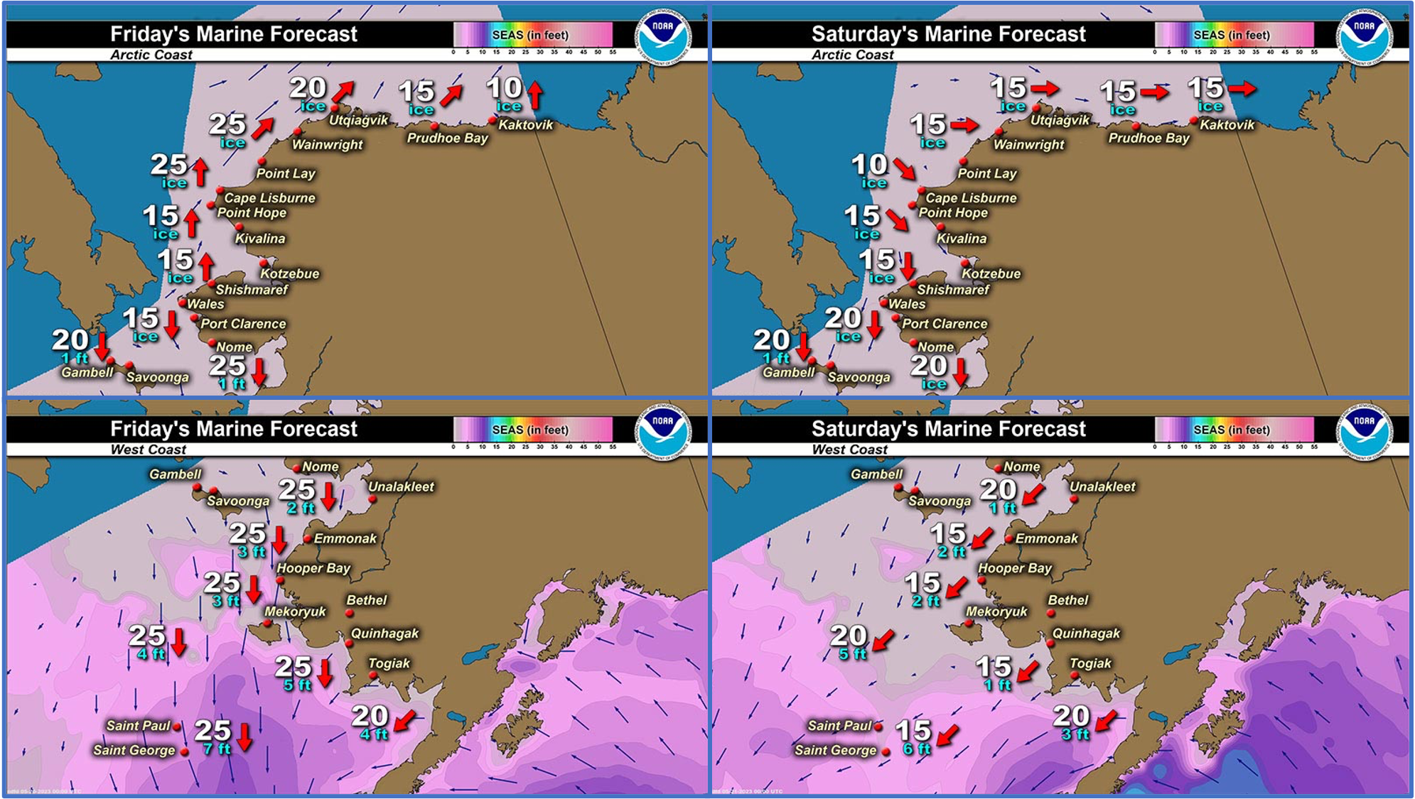
Marine forecast for the West Coast and Arctic Coast
Remote Sensing Images


Observations and Comments
Observations of Sea Ice Development
Observations from Shishmaref
Thursday, 18 May 2023 – Curtis Nayokpuk
Latest Polar View (17th.) for this weeks report. At least three crews "scouting " with snowmobiles areas down the coast (West ) and haven't heard any trip hunt success or ice conditions for boat launch sites. Shorefast ice broke up to beach line last week during South wind storm and if any indication of melt/ pooling water in community freezing at night there won't be any open ice free waters to launch from. Variable winds in FC and melt temps. mid-day so we shall see.

Friday, 19 May 2023 – Curtis Nayokpuk
First Oogruk reported taken by boat crew late yesterday! Numerous small birds of all species around but few ducks and cranes sighted (passing by) so far. Mist/fog late night into morning and FC warm sunny days with variable winds in the next few days.


Observations from Savoonga
Thursday, 11 May 2023 – Aqef Waghiyi
Wind southwest 10 knots, temperature 37 degrees, barometric pressure at 1010, and humidity 89. Little open water. Savoonga still iced in.

Observations from Gambell
Friday, 19 May 2023 – Clarence Irrigoo, Jr.
This week we have hi wind and high surf advisory, went to see the last ice by Savoonga area. Lots of male walrus.


Additional Comments Provided by Local Experts and Other Contributors
Shared by the Alaska Ocean Observing System (AOOS) for 17–25 May 2023
Visit the SIWO Facebook page @seaiceforwalrus to view this animation showing the predicted movement of ice predicted by the HYbrid Coordinate Ocean Model (HYCOM). Snapshots from the forecast show ice coverage from 0% (black) to 100% (white) and arrows show the relative speed and direction of the ice. A light boundary is drawn at 15% predicted ice cover to highlight the ice edge, but ice may be predicted to extend beyond it. Some bays, lagoons, and areas very close to shore are not covered by the model. (Image produced by the Alaska Ocean Observing System / Axiom Data Science).
