
Assessment of Current Ice Conditions Relevant to Distribution and Access of Walrus
Click the name of each community below to view more frequently updated and detailed information from the National Weather Service.
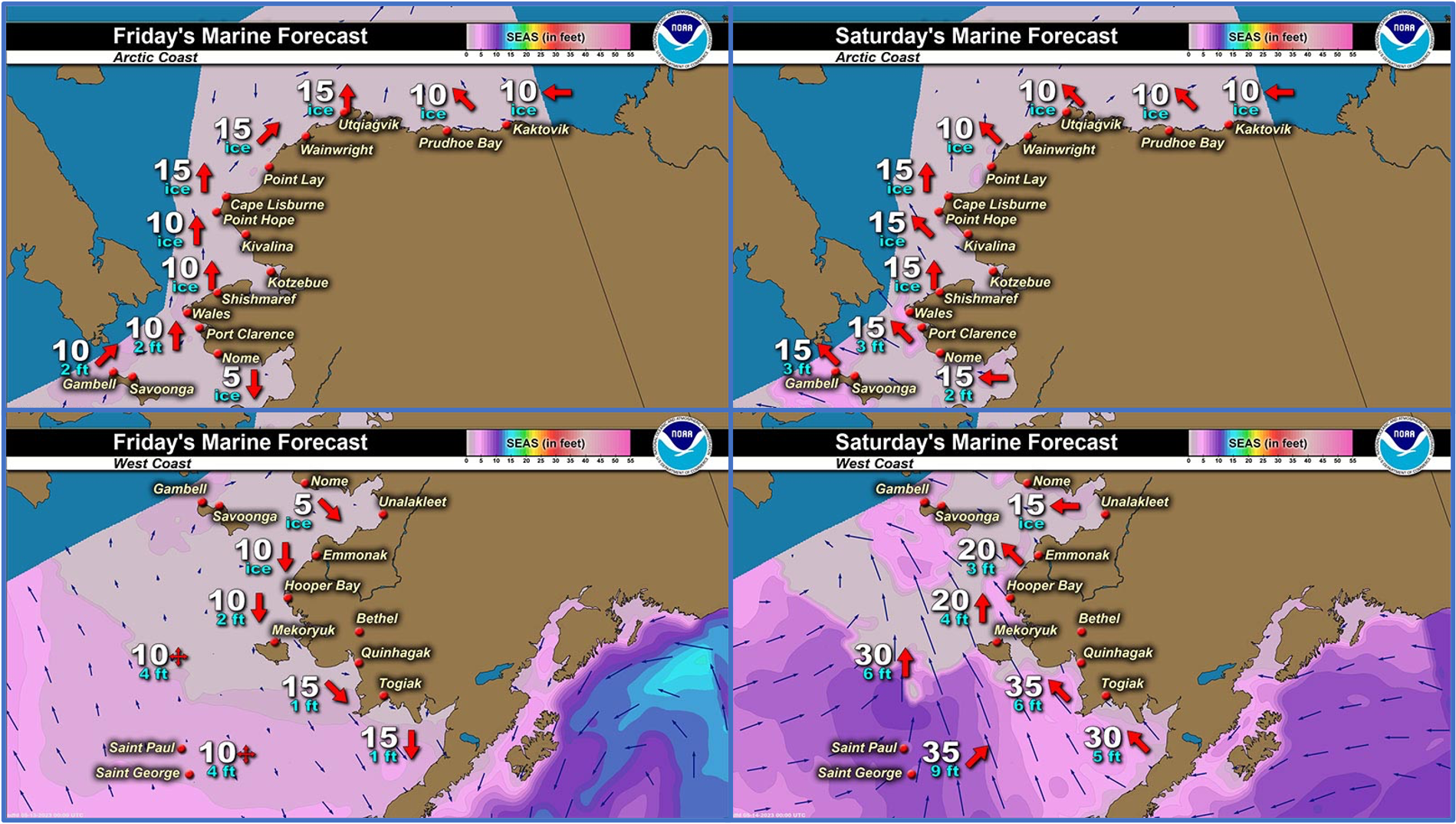
Synopsis High pressure over the Bering Strait persists through Friday night before a low from the southwest approaches the west coast. It will bring increased southwest-south winds and primarily rain through the weekend and possibly another round of rain through early next week.
Near St. Lawrence Island
Open water has greatly expanded since last week, stretching from 40 miles (64 km) northeast of Gambell to up to 130 miles (210 km) from the south coast of the island. There are several areas of open pack ice 40 to 70 miles (64 to 113 km) southwest to southeast of Gambell. The last round of southerly winds broke shorefast away along the northern coast, but some areas still remain. Between Gambell and Niyakpak Lagoon, shorefast ice extends up to 4 miles (6.5 km) away from the coast. Another area between Taphook Point and Kangee Camp extends up to 2.5 miles (4 km) away from the coast. East of Savoonga, a large portion of shorefast broke away, but shorefast remains from roughly Cape Kitnik through Camp Kulowiye up to 2 miles (3.2 km) from the coast. Shorefast from the east side through the south side of the island remains unchanged. The largest shorefast extent is in Oomeyaluk Bay, out up to 7 miles (11 km) from the coast. Very close pack of first year medium ice with small to vast floes exists from north of Savoonga through the east side of the island.
Nome
Shorefast ice remains unchanged from the previous week and extends up to 2 miles (3 km) offshore along the Nome coast, with the exception of up to 7 miles (11 km) offshore near Sledge Island. Beyond the shorefast ice is an area of open water that extends up to 13 mi (21 km) from the shorefast ice. Beyond the open water is open pack ice southwest of Nome to close pack ice southeast of Nome.
Nome port entrance webcam (via AOOS webpage): https://bering-sea.portal.aoos.org/?ls=79875242-e362-65cb-914e-fed20ff9…
Brevig Mission/Port Clarence Area
The outlook for this area has not yet begun for the season.
Wales to Shishmaref
The outlook for this area has not yet begun for the season.
Diomede
Shorefast ice remains between Big and Little Diomede with 9.5 miles (15.3 km) of north/south extent. Open water extends from 4.5 mi (7.2 km) east of Diomede to Wales. Otherwise, close pack ice exists of first year medium ice consisting of small to big floes.
Forecast Discussion
Ice Forecast
For St. Lawrence Island, an incoming front will bring stronger southerly winds to the area, which will put shorefast ice along the north side of the island at risk of breaking off. Regardless of shorefast, expect a large polynya to open up by the end of the weekend. Monday and Tuesday, northerly winds return which will bring close pack ice back to the coast.
For the Nome area coastline, southerly winds over the weekend will bring pack ice back to the northern coast/shorefast ice, closing off the existing polynya. The predominately southerly winds will encourage the pack ice to flow out of Norton Sound toward Port Clarence through next week.
For Diomede, southerly winds will keep a stream of close pack ice coming around the island. By the end of the weekend, the southerlies should close off the open water between Diomede and Wales with close pack ice. Early next week, northerly winds return which should bring more areas of open pack ice, or open water, especially toward Wales.


Wind Synopsis
Light and variable winds will continue through Friday outside of 5–15 kts (6–17 mph) southwest winds off the coast of Wales. Sustained winds pick up Saturday late morning out of the south to 15 to 25 kts (17–29 mph) with 25 to 35 kts (29–40 mph) along the southern side of the Seward Peninsula, gusting 30 to 40 kts (35-46 mph). These winds will persist until moving up the coast on Sunday morning and taper off for the evening. Monday will see increased winds from St. Lawrence Island to Wales around 15 to 25 kts (17–29 mph). After Monday, winds will be primarily 5 to 10 kts (6–11 mph) and variable winds direction next week.
Temperature Trend
St. Lawrence Island and Bering Strait will see temperatures in the mid to high 30s with lows in the upper 20s and low 30s, increasing through next week.
For Nome, temperatures will be in the upper 30s and low 40s with lows in the mid 20s and 30s, increasing through next week.
Diomede will see temperatures in the low to mid 30s with lows in the mid to upper 20s, increasing through next week.
Daily Weather, Wind, and Temperature Updates
The National Weather Service provides twice-daily, text only updates on the weather, wind, and temperature conditions in specific geographical zones. An interactive weather map for access to other Alaskan zones can be found here: http://weather.gov/anchorage/ice
Higher resolution satellite images and wind maps (wind updated daily) can be viewed here: http://www.weather.gov/afg/SIWO_overview
The Alaska Ocean Observing System shares a variety of weather and sea ice related resources in their Bering Sea Portal at https://bering-sea.portal.aoos.org/.
Marine forecast for the West Coast and Arctic Coast
Remote Sensing Images


Observations and Comments
Observations of Sea Ice Development
Observations from Shishmaref
Thursday, 11 May 2023 – Curtis Nayokpuk
Fog again this a.m. No chance to go out on ice to take a look at location of lead north. Better post latest pictures (solid ice 2) for next Friday? Will be a week or two to go out as my snowmobile needs new rear shocks and planned multi public meetings next week (WX...permitting).
Friday, 12 May 2023 – Curtis Nayokpuk
Third heavy fog morning. Couple hunters went out late last night (almost 24 hr. light) when visibility improved to 3-5 mile viz. and white out overcast condition but returned due to rough ice. Forecast high southerly winds (gust to 40?) for weekend so new leads will open up close to shore. Hope ALL the ice don't take off to the North, some boats still frozen to the ground with cold freezing nights.


Sunday, 14 May 2023 – Curtis Nayokpuk
Pictures from late last night Sat.13th. Gusty southerly winds and shorefast ice breaking up and moving east with tide/storm surge (?) into Kotz Sound. New ice ridges with pile up in some areas. Will see what daylight brings ...winds still gusting.


Observations from Savoonga
Thursday, 11 May 2023 – Aqef Waghiyi
Few boats went out boating and got walrus and one of the boats got female with calf. 10 knots from SSW. Barometric pressure was 1001. Humidity was 92%. It was foggy all day until around 5pm, that’s when I heard the boats going out.
Observations from Gambell
Friday, 12 May 2023 – Clarence Irrigoo, Jr.
May 6 and 7 lots of walrus show up around Gambell, some are getting to the ice. This ice is now way up north. Yesterday some went out and some got walrus.


Additional Comments Provided by Local Experts and Other Contributors
Shared by the Alaska Ocean Observing System (AOOS) for 10–18 May 2023
Visit the SIWO Facebook page @seaiceforwalrus to view this animation showing the predicted movement of ice predicted by the HYbrid Coordinate Ocean Model (HYCOM). Snapshots from the forecast show ice coverage from 0% (black) to 100% (white) and arrows show the relative speed and direction of the ice. A light boundary is drawn at 15% predicted ice cover to highlight the ice edge, but ice may be predicted to extend beyond it. Some bays, lagoons, and areas very close to shore are not covered by the model. (Image produced by the Alaska Ocean Observing System / Axiom Data Science).

Shared by the National Weather Service Alaska Sea Ice Program
Thursday, 11 May 2023
A front moving onto the west coast of Alaska will bring gusty southerly winds over the weekend and the chance to break shorefast ice away from the coast.
https://www.weather.gov/afc/ice_satelliteResources

Tuesday, 9 May 2023
Melt season is underway as the ice edge is nearing the Kuskokwim Delta. Shorefast ice is beginning to erode from the edge. Pack ice is thinning out while open water areas grow.
