
Assessment of Current Ice Conditions Relevant to Distribution and Access of Walrus
Click the name of each community below to view more frequently updated and detailed information from the National Weather Service.
Synopsis – Strong high pressure over the Bering Strait will move over the western Bering Sea on Saturday. A cold front moving southwest across interior Alaska will move along the west coast of Alaska on Saturday, and move west of St. Lawrence Island and the Bering Strait on Saturday night and Sunday.
Near St. Lawrence Island
Clouds have made viewing of the area tough the last couple of days. However, the ice pack situation looks much the same as the last couple of weeks. Light northerly winds have compacted ice against the shorefast ice out to 50 to 100 mi (80 to 160 km) from the coast. Compacted against the shorefast is predominately first-year medium and thin ice with lower concentrations of young. Shorefast ice remains along the northern side of the island. Shorefast extends out up to 10 miles (16 km) from the coastline between Gambell and Eewak Point and extends out 2 to 10 miles (3 to 16 km) offshore from east of Savoonga through Camp Kulowiye.
On the southern side of the island, shorefast remains within the bays. The largest shorefast extent is in Oomeyaluk Bay, out up to 7 miles (11 km) from the coast. A large area of open water exists on the southern side of the island and extends outward from the shorefast ice up to 100 miles (160 km). A stream of close pack ice composed of first year medium and thin is streaming southward west of Gambell with open water 6 miles (10 km) east of Gambell beyond the pack ice.
Nome
Clouds have made viewing of the area tough the last couple of days. However, the ice pack situation looks much the same as the last couple of weeks. Shorefast ice extends up to 2 miles (3 km) offshore along the Nome coast, with the exception of up to 7 miles (11 km) offshore near Sledge Island. Beyond the shorefast ice is a large area of close to very close pack ice consisting of medium to vast floes up to 40 miles (64 km) south of Nome. There is open water south of the shorefast ice up to 8 miles off the coast east of Solomon.
Nome port entrance webcam (via AOOS webpage): https://bering-sea.portal.aoos.org/?ls=79875242-e362-65cb-914e-fed20ff9…
Brevig Mission/Port Clarence Area
The outlook for this area has not yet begun for the season.
Wales to Shishmaref
The outlook for this area has not yet begun for the season.
Diomede
The outlook for this area has not yet begun for the season.
Forecast Discussion
Ice Forecast
For St. Lawrence Island, light southerly winds will continue through Saturday. This will begin to close the polynya on the south side of the island, but not all the way to the coast; there will still likely be open water. The southerly winds will likely not be enough to affect the shorefast ice on the north side of the island, but will decompress the pack ice a little bit and make areas a little more open but still high concentration. A strong front approaches on Sunday/Monday, which will bring stronger northerly winds back to the area, returning the ice picture much like what we have seen over the last couple weeks. These winds will potentially be strong enough to affect the shorefast ice on the south side of the island; those winds will continue through Tuesday.
For the Nome area coastline, light northerly winds through Saturday could push pack ice to the south, opening up a small polynya along the coast. Stronger northerly winds return Sunday and Monday, which will move the higher concentration pack ice back to the south and open up a larger polynya along the northern coast. Some of the less stable portions of shorefast ice along the coast from Sledge Island to Norton Bay may break off during these northerly winds.


Long duration northerly winds have kept a large polynya open south of St. Lawrence Island (see annotated image above for 5 May 2023). Southerly winds this weekend may close the polynya slightly and push compacted ice away from the shorefast ice on the north shore.
Wind Synopsis
Light and variable winds will continue into Saturday. Winds will turn north 15 to 25 kt on Sunday night across St. Lawrence Island with 5 to 10 kt around Nome. This will persist through Tuesday with winds becoming southwest to 10 to 15 kt Wednesday and Thursday across St. Lawrence Island with light and variable winds around Nome.
Temperature Trend
St. Lawrence Island and Bering Strait temps will be in the teens and 20s through the week, rising slightly mid-week. Nome temps will be near in the low 30s rising into the upper 30s this weekend through midweek. Lows will be in the low to mid 20s.
Daily Weather, Wind, and Temperature Updates
The National Weather Service provides twice-daily, text only updates on the weather, wind, and temperature conditions in specific geographical zones. An interactive weather map for access to other Alaskan zones can be found here: http://weather.gov/anchorage/ice
Higher resolution satellite images and wind maps (wind updated daily) can be viewed here: http://www.weather.gov/afg/SIWO_overview
The Alaska Ocean Observing System shares a variety of weather and sea ice related resources in their Bering Sea Portal at https://bering-sea.portal.aoos.org/.
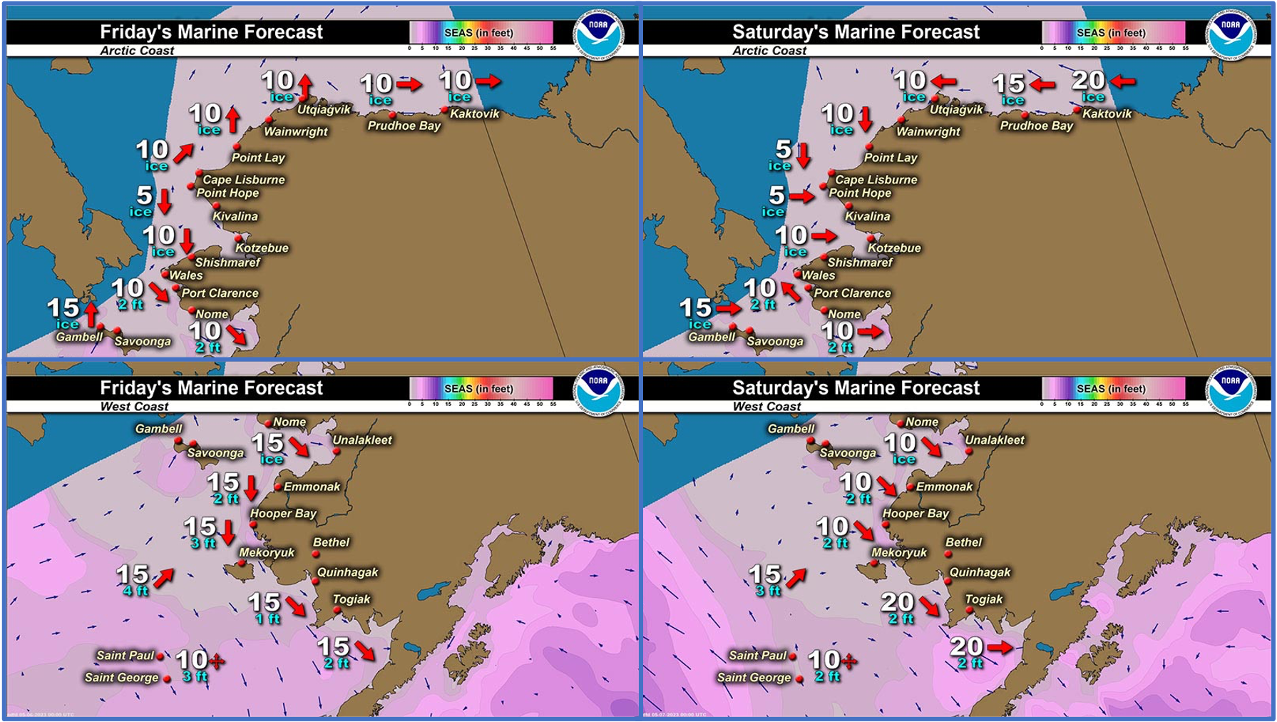
Marine forecast for the West Coast and Arctic Coast
Remote Sensing Images


Observations and Comments
Observations of Sea Ice Development
Observations from Savoonga
Thursday, 4 May 2023 – Aqef Waghiyi
Had about three feet of powder snow in two days. Very light breeze today – the machine can’t read it.
Temperature - 33 deg F
Humidity - 78
Pressure - 1006 hPa
No open water yet. This year not much open water for us. There’s people boating right now down at south side. Earlier today I heard they were chasing a whale but haven’t heard anything else. Nobody said anything about anybody getting walrus down there, no seals either, but they seen some. Guess they want to get one more whale before turning to walrus and seals.


Observations from Gambell
Friday, 5 May 2023 – Clarence Irrigoo, Jr.
Most of the boats went out yesterday, see lots of bearded seal and walrus on ice. Yesterday was good day for hunting after 10 days of bad weather. Snowing little bit here.


Observations from Diomede
Saturday, 5 May 2023 – Marty Eeleengayouq Ozenna
There's still ice to the north and to the south it's open water.


Observations from Shishmaref
Sunday, 7 May 2023 – Curtis Nayokpuk
Solid ice out front and very jagged crushed ice ridges from about three miles offshore to horizon. Warm sunny days hunters digging out boats and prepping gear (boat sled needs work) for spring season. Lead opening north of Shishmaref on WorldView site so looks like a place to start early season Bearded Seal hunts with snowmobiles. Will take a look mid-week after FC north winds to 20 MPH. Polar View site should have detailed maps by then to plot route thru jagged ice.


Observations from Port Clarence, Brevig Mission, and Cape Douglas
Saturday, 6 May 2023 – Marcus Barr
Port Clarence shorefast ice. Rough ice most parts, bunch of seals started sun-bathing and ice edge is far out still.

Additional Comments Provided by Local Experts and Other Contributors
Shared by the Alaska Ocean Observing System (AOOS) for 3–11 May 2023
Visit the SIWO Facebook page @seaiceforwalrus to view this animation showing the predicted movement of ice predicted by the HYbrid Coordinate Ocean Model (HYCOM). Snapshots from the forecast show ice coverage from 0% (black) to 100% (white) and arrows show the relative speed and direction of the ice. A light boundary is drawn at 15% predicted ice cover to highlight the ice edge, but ice may be predicted to extend beyond it. Some bays, lagoons, and areas very close to shore are not covered by the model. (Image produced by the Alaska Ocean Observing System / Axiom Data Science).

Shared by the NWS Alaska Sea Ice Program
Sunday, 7 May 2023
Yesterday afternoon (Saturday, 6 May) satellite image shows evidence of shorefast ice breaking away between Gambell and Savoonga due to southerly winds. Winds are expected to shift from the north on Monday.
