
Assessment of Current Ice Conditions Relevant to Distribution and Access of Walrus
Click the name of each community below to view more frequently updated and detailed information from the National Weather Service.
Synopsis Strong high pressure over the Bering Strait will move over the western Bering Sea on Saturday. A cold front moving southwest across interior Alaska will move along the west coast of Alaska on Saturday, and move west of St. Lawrence Island and the Bering Strait on Saturday night and Sunday.
Near St. Lawrence Island
Between Gambell and Eewak Point, compacted ice has become shorefast up to 10 miles (16 km) from the coastline. This ice has not been tested by strong southerly winds recently, so there is a question of how strongly fasted to the shore it is. East of Savoonga through Camp Kulowiye, shorefast ice remains intact 2 to 10 miles (3 to 16 km) offshore with the same compacted ice fasted to either the shoreline or previously grown shorefast ice, and continues around the east and south coasts. The farthest extent of the shorefast ice is between Siknik Training Camp and Camp Kulowiye. A polynya off the south coast has refrozen with new ice and extends 2 to 4 miles (3 to 6.5 km) off the shorefast ice. From Gambell through Powooiliak Camp, close to very close young pack ice exists with intermingled medium to vast floes of older first year medium ice. Otherwise, there is generally very close pack ice to consolidated ice consisting of vast to giant floes surrounding the island.
Nome
Shorefast ice extends up to 2 miles (3 km) offshore along the Nome coast, with the exception of up to 7 miles (11 km) offshore near Sledge Island. A large area of close to very close young pack ice extends southward from Sledge Island. Consolidated ice consisting of vast to giant floes extends 65 miles (105 km) south of Nome. A former polynya has filled with new ice between Port Safety and Golovin Bay.
Nome port entrance webcam (via AOOS webpage): https://bering-sea.portal.aoos.org/?ls=79875242-e362-65cb-914e-fed20ff9…
Brevig Mission/Port Clarence Area
The outlook for this area has not yet begun for the season.
Wales to Shishmaref
The outlook for this area has not yet begun for the season.
Diomede
The outlook for this area has not yet begun for the season.
Forecast Discussion
Ice Forecast
For St. Lawrence Island, the polynya on the south side of the island will continue to expand to the south through the week as northerly winds persist. Expect ice to compact against the northern coastline. Colder air remains overhead, which will keep thickness steady with little melting other than the late-April sunshine.
For the Nome area coastline, sea ice will move predominately with tides and currents through the weekend. Into next week, there is a better chance sea ice will move southward with stronger northerly winds which will encourage a polynya to form south of the shorefast ice. Some of the less stable portions of shorefast ice along the coast from Sledge Island to Norton Bay may break off during the northerly winds.


Wind Synopsis
Light and variable winds will continue into Friday. Winds will turn north 10 kt on Friday night. North winds from the Bering Strait to St. Lawrence Island will increase to 20 kt Saturday, and to northeast 20–25 kt on Sunday, which will continue through much of next week.
At Nome, winds will remain light through Friday, then become north 5–10 kt Friday night, and northeast 10–15 kt Saturday, which will continue through much of next week.
Temperature Trend
St. Lawrence Island and Bering Strait temps will be in the teens and 20s through next week. Nome temps will be lows in teens and highs in the 30s Friday and Saturday, then fall to the lows near 10 and highs in the 20s from Sunday through next week.
Daily Weather, Wind, and Temperature Updates
The National Weather Service provides twice-daily, text only updates on the weather, wind, and temperature conditions in specific geographical zones. An interactive weather map for access to other Alaskan zones can be found here: http://weather.gov/anchorage/ice
Higher resolution satellite images and wind maps (wind updated daily) can be viewed here: http://www.weather.gov/afg/SIWO_overview
The Alaska Ocean Observing System shares a variety of weather and sea ice related resources in their Bering Sea Portal at https://bering-sea.portal.aoos.org/.
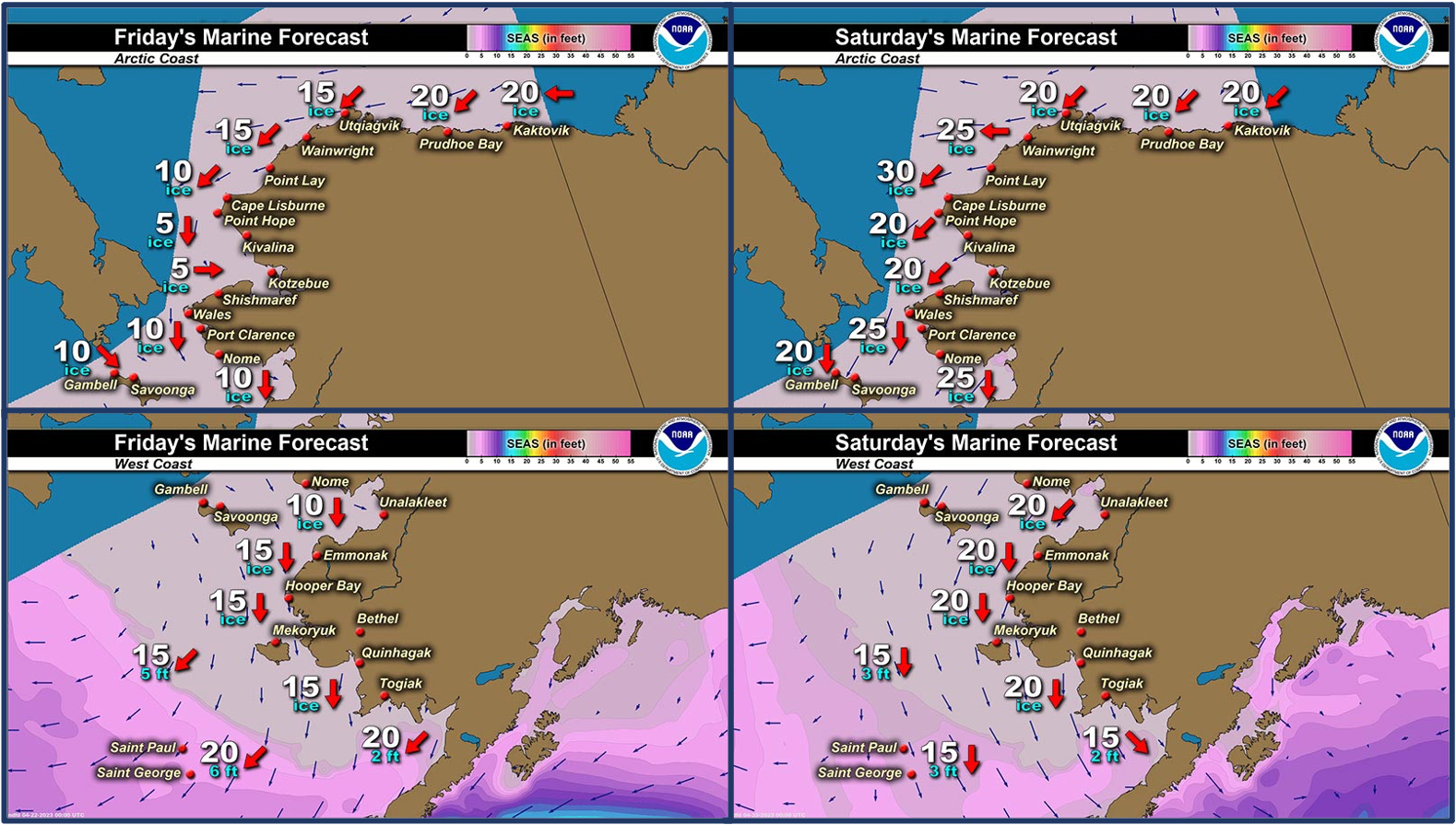
Marine forecast for the West Coast and Arctic Coast
Remote Sensing Images


Observations and Comments
Observations of Sea Ice Development
Observations from Savoonga
Thursday, 20 April 2023 – Aqef Waghiyi
Little breeze from the north. Wind meter doesn’t do too good on anything lower than 7 knots. 10 kts from north. Warm out. Nobody went out boating or anything this week. Went boating down at whaling camp and got a whale. The barometer pressure is at 1007. 28 deg earlier when I took the temp. People are still getting their whaling stuff ready. Some people are gonna head down south. Past two days every morning we’d see walrus go by in front of town. They came from the west side going east. All bulls. Females are probably south of the island still. I’ll be going down south Saturday or Sunday and hopefully go boating. Hoping to get females when we go boating down there.


Observations from Gambell
Friday, 21 April 2023 – Clarence Irrigoo, Jr.
All week we have dense fog and the temp around 25°. Calm and foggy all week.


Three foot waves since yesterday.

Kittiwakes on April 18.

Observations from Port Clarence, Brevig Mission, and Cape Douglas
Friday, 21 April 2023 – Marcus Barr
Shorefast ice near Cape Douglas looks to be thinner ice. No hunting yet.

Additional Comments Provided by Local Experts and Other Contributors
Shared by the Alaska Ocean Observing System (AOOS) for 18–25 April 2023
Visit the SIWO Facebook page @seaiceforwalrus to view this animation showing the predicted movement of ice predicted by the HYbrid Coordinate Ocean Model (HYCOM). Snapshots from the forecast show ice coverage from 0% (black) to 100% (white) and arrows show the relative speed and direction of the ice. A light boundary is drawn at 15% predicted ice cover to highlight the ice edge, but ice may be predicted to extend beyond it. Some bays, lagoons, and areas very close to shore are not covered by the model. (Image produced by the Alaska Ocean Observing System / Axiom Data Science).

Shared by Rick Thoman, ACCAP
Thursday, 20 April 2023
Thursday afternoon satellite courtesy UAF GINA is quite revealing, showing a rather large area of grey thin northwest to southwest of Nome. An area of open water has also opened up in Norton Bay. Quite dynamic looking ice between Gambell and Chukotka with large floes but significant water between them. In spite of the recent cold spell, Bering ice is looking distinctly "spring-like".
