
Assessment of Current Ice Conditions Relevant to Distribution and Access of Walrus
Click the name of each community below to view more frequently updated and detailed information from the National Weather Service.
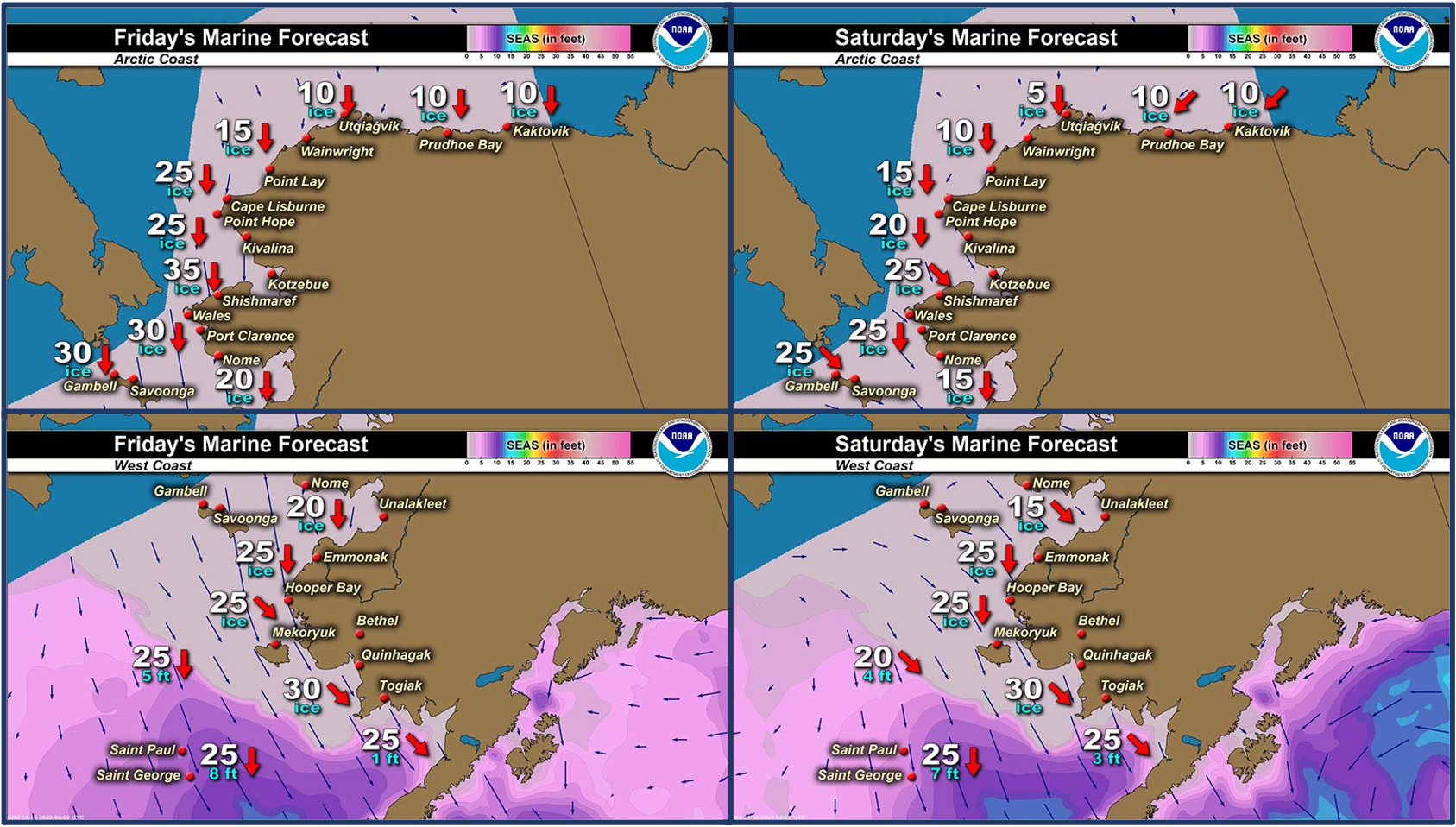
Synopsis A low over the southern Bering Sea will move into the Gulf of Alaska Thursday. High pressure will build over the Bering Sea Friday through Monday.
Near St. Lawrence Island
Shorefast ice remains intact 2 to 12 miles (3 to 19 km) offshore east of Savoonga as well as along the south and east coasts. The farthest extent of the shorefast ice is between Siknik Training Camp and Camp Kulowiye. A polynya off the south and west coasts is most extensive from Gambell to the southeast corner of the island, extending up to 25 miles (22 km) beyond the shorefast ice. The polynya is quickly filling in with new sea ice. Aside from the polynyas, there is generally very close pack ice to consolidated ice consisting of vast to giant floes.
Nome
Shorefast ice extends up to 2 miles (3 km) offshore along the Nome coast, with the exception of up to 7 miles (11 km) offshore near Sledge Island. Consolidated ice consisting of vast to giant floes extends 65 miles (105 km) south of Nome. A polynya off the west side of the Seward Peninsula is quickly filling in with new ice.
Nome port entrance webcam (via AOOS webpage): https://bering-sea.portal.aoos.org/?ls=79875242-e362-65cb-914e-fed20ff9…
Brevig Mission/Port Clarence Area
The outlook for this area has not yet begun for the season.
Wales to Shishmaref
The outlook for this area has not yet begun for the season.
Diomede
The outlook for this area has not yet begun for the season.
Forecast Discussion
Ice Forecast
For St. Lawrence Island, the polynya on the south side of the island will continue to expand to the south through the week, and will continue to quickly fill in with new ice as the unseasonably cold air remains over the region. The ice pack will generally shift with the winds and sea ice thickness will remain fairly steady.
For the Nome area coastline, the ice pack will move to the south through the weekend, then move with the local currents Monday through Thursday. A polynya will likely form during this time to the south of the shorefast ice. Some of the less stable portions of shorefast ice along the coast from Sledge Island to Norton Bay may break off during the stronger northerly winds this weekend.


Wind Synopsis
North winds of 20–35 mph (17–30 kt) will turn west Saturday, 15 April near St. Lawrence Island around 10–20 mph (9–17 kt). Winds are expected to become northerly again Sunday around 10–20 mph (9–17 kt), then become light and variable Monday, 17 April through Thursday, 20 April. At Nome, north winds of 10 to 20 mph (9–17 kt) Friday through Sunday (April 14–16) are expected. Winds will become light and variable Monday, 17 April through Thursday, 20 April.
Temperature Trend
For St. Lawrence Island, high temperatures are expected to be in the upper single digits to low teens above from Friday, 14 April to Monday, 17 April. High temperatures will increase into the low to mid 20s Tuesday through Thursday (18-20 April). Low temperatures are expected to be in single digits above Friday, 14 April to Tuesday, 18 April. Low temperatures are expected to increase into the low tens above Wednesday and Thursday (19–20 April).
For Nome, high temperatures in the upper single digits above are expected Friday, 14 April, then warming to the low to mid-teens above Saturday through Tuesday (15–18 April). High temperatures are expected to increase into the low 20s above Wednesday and Thursday (19–20 April). Low temperatures in the single digits below are expected Friday, 14 April through Monday, 17 April. Low temperatures are expected to increase into the low to mid-single digits above on Tuesday, 18 April and remain through the rest of the week.
Daily Weather, Wind, and Temperature Updates
The National Weather Service provides twice-daily, text only updates on the weather, wind, and temperature conditions in specific geographical zones. An interactive weather map for access to other Alaskan zones can be found here: http://weather.gov/anchorage/ice
Higher resolution satellite images and wind maps (wind updated daily) can be viewed here: http://www.weather.gov/afg/SIWO_overview
The Alaska Ocean Observing System shares a variety of weather and sea ice related resources in their Bering Sea Portal at https://bering-sea.portal.aoos.org/.
Marine forecast for the West Coast and Arctic Coast
Remote Sensing Images


Observations and Comments
Observations of Sea Ice Development
Observations from Gambell
Friday, 14 April 2023 – Clarence Irrigoo, Jr.
Windy last two days, yesterday open up and was very choppy.


Boats ready for hunting.

Boat towing a bearded seal.
Observations from Savoonga
Friday, 14 April 2023 – Aqef Waghiyi
No open water. Everybody’s in Gambell for middle schooler’s basketball. Its -5 degrees out and 18–24 west wind. Kinda chilly today.


Observations from Wales
Friday, 15 April 2023 – Robert Tokeinna, Jr.
For the past couple of weeks, it's been cold and clear out lately. Winds are out of the north to prominent northeast winds, but for a couple days it turn south wind just to turn back north ranging from calm to 45 mph at times, but averaged out to 15 to 20 most times. Very cold single digits to in minus teens with wind chill factor into -40s but leveling to and averaging minus teens with wind chill. For sea ice, it seems to be sticking around and still can see flow ice as far as the eye can see. Very little signs of spring, I noticed some seagulls around and spotted one snow bunting bird. There was a dog that showed up and no one knew where it came from. Low and behold local residents posted on Facebook, and now the dog is reunited with his family in Gambell with the help of our Wales Seawolves NYO team ferrying him back to Gambell. It still baffles me on how he lived and survived the 150 mile trip to Wales over flow and shorefast ice. Happy for the reunion and safe return to the friendly traveler in Gambell, very blessed and quite a story to hear of this embarkment over sea ice.

Additional Comments Provided by Local Experts and Other Contributors
Shared by the Alaska Ocean Observing System (AOOS) for 12–20 April 2023

Visit the SIWO Facebook page @seaiceforwalrus to view this animation showing the predicted movement of ice predicted by the HYbrid Coordinate Ocean Model (HYCOM). Snapshots from the forecast show ice coverage from 0% (black) to 100% (white) and arrows show the relative speed and direction of the ice. A light boundary is drawn at 15% predicted ice cover to highlight the ice edge, but ice may be predicted to extend beyond it. Some bays, lagoons, and areas very close to shore are not covered by the model. (Image produced by the Alaska Ocean Observing System / Axiom Data Science).