
Assessment of Current Ice Conditions Relevant to Distribution and Access of Walrus
Click the name of each community below to view more frequently updated and detailed information from the National Weather Service.
Synopsis High pressure lingers over much of the pack through Monday while a low spins up in the Gulf of Alaska over the weekend. A strong front comes into the southern Bering Sea early next week. A weak low forms in the Beaufort and Chukchi seas over the weekend.
Near St. Lawrence Island
Shorefast ice remains intact 2 to 6 miles (3 to 10 km) offshore east of Savoonga as well as along the south and east coasts. A polynya off the south and east coasts is most extensive from Camp Kulowiye to the southeast part of the island, extending up to 16 miles (26 km) beyond the shorefast ice. Off the south side of the island, another smaller polynya extends up to 8 miles (13 km) beyond the shorefast ice. Both polynyas have filled in with new ice this week. Aside from the polynyas, there is generally close pack ice consisting of vast to giant floes with the exception of consolidated to compact pack ice consisting of vast to giant floes to the south and southwest of the island.
Nome
Shorefast ice extends up to 2 miles (3 km) offshore along the Nome coast, with the exception of up to 7 miles (11 km) offshore near Sledge Island. Consolidated ice consisting of vast to giant floes extends 65 miles (105 km) south of Nome. There is a small polynya from Port Safety to Topkok that extends up to 3 miles (5 km) beyond the shorefast ice and has filled in with new ice.
Nome port entrance webcam (via AOOS webpage): https://bering-sea.portal.aoos.org/?ls=79875242-e362-65cb-914e-fed20ff9…
Brevig Mission/Port Clarence Area
The outlook for this area has not yet begun for the season.
Wales to Shishmaref
The outlook for this area has not yet begun for the season.
Diomede
The outlook for this area has not yet begun for the season.
Forecast Discussion
Ice Forecast
For St. Lawrence Island, the polynya on the south side of the island will expand to the south through the week, though it will shift east and west a bit as winds shift, especially this weekend. Otherwise, a cool airmass over the Bering Strait region through the next week, the ice pack will generally shift with the winds and sea ice thickness will remain fairly steady.
For the Nome area coastline, the ice pack will move to the southeast through the weekend, then move with the local currents Monday. Sea-ice movement will be to the south Tuesday through Thursday, and a polynya will likely form during this time to the south of the shorefast ice. Some of the less stable portions of shorefast ice along the coast from Sledge Island to Norton Bay may break off during these northerly winds.


Wind Synopsis
North to northeast winds of 10–15 mph (8–13kt) will turn west Saturday, 8 April near St. Lawrence Island around 5–10 mph (3–8kt). Winds are expected to remain westerly around 5–10 mph (3–8kt) through the rest of the week. At Nome, north winds of 5 to 10 mph (3–8kt) Friday and Saturday (8 April) are expected. Winds will turn west around 10–15 mph (8–13kt) on Sunday, 9 April, and remain through the rest of the week.
Temperature Trend
For St. Lawrence Island, high temperatures are expected to be in the low to mid-single digits above from Friday, 7 April to Saturday, 8 April. High temperatures will increase into the low to mid 10s above Sunday, 9 April and remain similar the rest of the week. Low temperatures are expected to be in the low to mid 10s below Friday, 7 April and Saturday, 8 April. Low temperatures are expected to increase into the low to mid-single digits above from Sunday, 9 April and remain through the rest of the week.
For Nome, high temperatures in the low to mid-single digits above are expected Friday, 7 April through Monday, 10 April. High temperatures are expected to increase into the low 10s above Tuesday, 11 April and remain through the rest of the week. Low temperatures in the low to mid 10s below are expected Friday, 7 April through Sunday, 9 April). Low temperatures are expected to increase into the low to mid-single digits below on Monday, 10 April and remain through the rest of the week.
Daily Weather, Wind, and Temperature Updates
The National Weather Service provides twice-daily, text only updates on the weather, wind, and temperature conditions in specific geographical zones. An interactive weather map for access to other Alaskan zones can be found here: http://weather.gov/anchorage/ice
Higher resolution satellite images and wind maps (wind updated daily) can be viewed here: http://www.weather.gov/afg/SIWO_overview
The Alaska Ocean Observing System shares a variety of weather and sea ice related resources in their Bering Sea Portal at https://bering-sea.portal.aoos.org/.
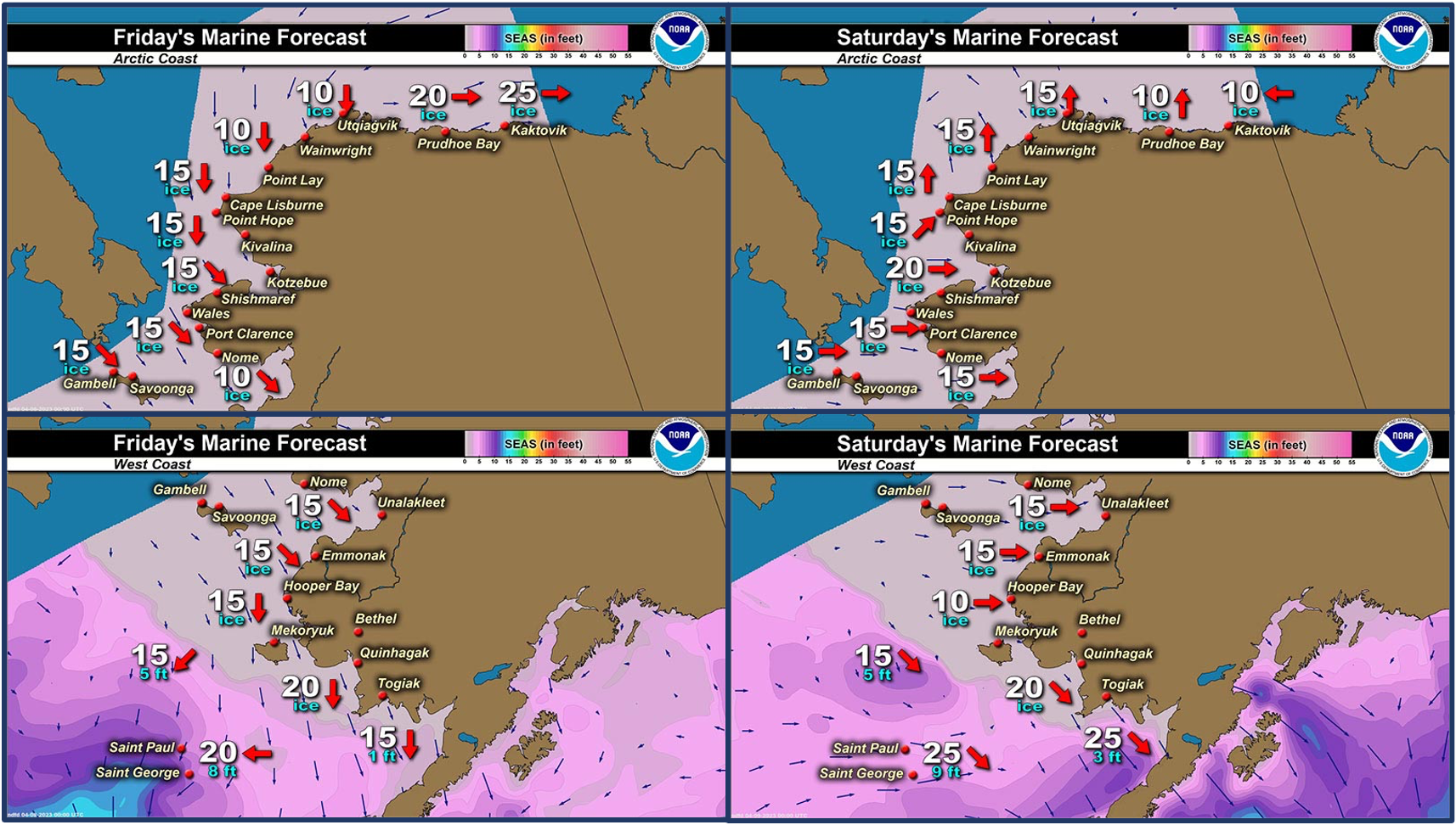
Marine forecast for the West Coast and Arctic Coast
Remote Sensing Images


Observations and Comments
Observations of Sea Ice Development
Observations from Shishmaref
Thursday, 6 April 2023 – Curtis Nayokpuk
A little early yet for our area maybe in a month or so? Who knows.... looking at all the lack of shore fast ice along Wales to Shish. coast could be early spring with off shore winds sending any solid ice North? Good potential Bearded Seals will be early following shoreline (direct from Wales East into Kotz. Sound) vs. (past/historical) going around a 30 to 50 mile solid Wales Shoal (grounded ice) line before entering Shishmaref traditional hunting waters.

Observations from Savoonga
Thursday, 6 April 2023 – Aqef Waghiyi
No open water. It closed up.
Friday, 7 April 2023 - Update
Windy NNW 4.9 mph. Crosswind is as 2 mph. Humidity 56.4. Dewpoint -13.1. Barometer 1007.5. Temperature -1.9. Windchill -13.
Will send pics in about half an hour. Few people went down to whaling camp, but they’re gonna be coming back, just dropping off whaling gear.


Observations from Gambell
**Thursday, 6 April 2023 – Clarence Irrigoo, Jr.*
Starting whaling, boats are out. 1° NE 13 mph, water is kinda small. Will take photo later, no walrus on ice yet but seen two ivory gulls earlier.
Update 7:00 p.m. - NE 2° 10mph. Five boats went out today, no word what they got.


Observations from Port Clarence, Brevig Mission, and Cape Douglas
Thursday, 6 April 2023 – Marcus Barr
Shorefast ice looks like it may have cracks near the edge. Also out near Cape Douglas may have open spots or thin ice. I haven't gone out in person yet to observe the ice but have been on the ice maps.

Additional Comments Provided by Local Experts and Other Contributors
Shared by the Alaska Ocean Observing System (AOOS) for 5–13 April 2023
Visit the SIWO Facebook page @seaiceforwalrus to view this animation showing the predicted movement of ice predicted by the HYbrid Coordinate Ocean Model (HYCOM). Snapshots from the forecast show ice coverage from 0% (black) to 100% (white) and arrows show the relative speed and direction of the ice. A light boundary is drawn at 15% predicted ice cover to highlight the ice edge, but ice may be predicted to extend beyond it. Some bays, lagoons, and areas very close to shore are not covered by the model. (Image produced by the Alaska Ocean Observing System / Axiom Data Science).
