
Assessment of Current Ice Conditions Relevant to Distribution and Access of Walrus
Click the name of each community below to view more frequently updated and detailed information from the National Weather Service.
Synopsis A low in the western Bering Sea will move northeast toward the Yukon Delta Thursday. High pressure will then build over the southern Bering Sea as another low moves east across the Chukchi Sea then moves north to the High Arctic on Monday.
Near St. Lawrence Island
Shorefast ice remains intact 2 to 6 miles (3 to 10 km) offshore from Camp Iveetok east as well as along the south and east coasts. A large polynya has opened up off the north side of the island, most extensive from Savoonga east to Lietnik to approximately 60 miles (97 km) north. This polynya has new ice formation, especially beyond 15 to 20 miles (24 to 32 km) from shore. Between Gambell and Savoonga, the polynya is up to 13 miles (21 km) wide. To the west and north of Gambell is close pack ice consisting of vast to giant floes. Otherwise, there is consolidated to compact pack ice consisting of vast to giant floes surrounding the island.
Nome
Shorefast ice extends up to 2 miles (3 km) offshore along the Nome coast, with the exception of up to 7 miles (11 km) offshore near Sledge Island. Consolidated ice consisting of vast to giant floes extends 65 miles (105 km) south of Nome.
Nome port entrance webcam (via AOOS webpage): https://bering-sea.portal.aoos.org/?ls=79875242-e362-65cb-914e-fed20ff9…
Brevig Mission/Port Clarence Area
The outlook for this area has not yet begun for the season.
Wales to Shishmaref
The outlook for this area has not yet begun for the season.
Diomede
The outlook for this area has not yet begun for the season.
Forecast Discussion
Ice Forecast
The wind will shift multiple times in the next week; the ice pack around St. Lawrence Island will be quite mobile. Expect a polynya to open on the south side of the island during times of northerly winds and close again during times of southerly winds. North of the island, the existing polynya will become smaller but likely not close completely during northerly winds and grow again during times of southerly winds.
For the Nome area coastline, a polynya will form Friday but close again on Saturday. Overall, expect the ice pack to remain consolidated over the northern portion of the sound through the week.


Wind Synopsis
North to northwest winds of 10–15 mph (8–13 kt) will turn west tomorrow, 31 March, near St. Lawrence Island at 15–20 mph (13–17 kt), then west at Nome Friday night at 5–10 mph (4–8 kt). On Saturday, 1 April winds will turn southwest at 15–25 mph (13–22 kt) with the strongest winds near Gambell and north of Savoonga near the north shore of St. Lawrence Island. Winds will turn northwest and weaken on Sunday, 2 April. East and northeast winds 5–15 mph (4–13 kt) are expected for most of next week, with northeast winds increasing to 15–20 mph (13–17 kt) on Thursday and Friday near St. Lawrence Island.
Temperature Trend
High temperatures on Friday, 31 March and Saturday, 1 April will be in the mid to upper 20s before a cooling trend begins Sunday, 1 April. Sunday through next week, highs will be in the mid to upper teens with slightly warmer temperatures (low 20s) in Gambell and Savoonga. Low temperatures on Friday, 31 March will be in the high single digits near St. Lawrence Island and in the mid-teens near Nome. Lows on Saturday will be in the upper teens on St. Lawrence Island and in the mid-teens again near Nome. Sunday morning will bring colder temperatures with lows in the mid-single digits. Lows through next week will be between 0 and 10 degrees above zero, with the warmest temperatures near Gambell and Savoonga.
Daily Weather, Wind, and Temperature Updates
The National Weather Service provides twice-daily, text only updates on the weather, wind, and temperature conditions in specific geographical zones. An interactive weather map for access to other Alaskan zones can be found here: http://weather.gov/anchorage/ice
Higher resolution satellite images and wind maps (wind updated daily) can be viewed here: http://www.weather.gov/afg/SIWO_overview
The Alaska Ocean Observing System shares a variety of weather and sea ice related resources in their Bering Sea Portal at https://bering-sea.portal.aoos.org/.
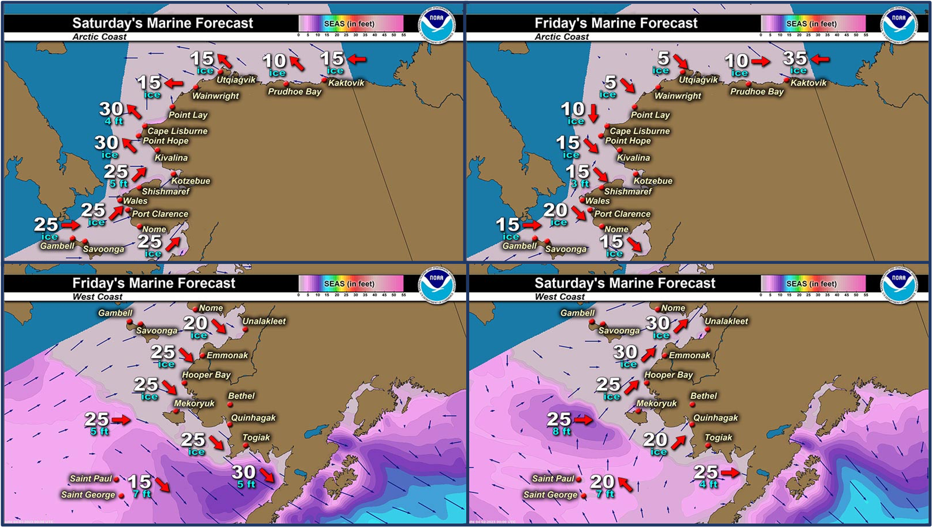
Marine forecast for the West Coast and Arctic Coast
Remote Sensing Images


Observations and Comments
Observations of Sea Ice Development
Observations from Savoonga
Wednesday, 29 March 2023 – Aqef Waghiyi
Few boats went out and they got bearded seal and some got walrus.
Observations from Gambell
**Wednesday, 29 March 2023 – Clarence Irrigoo, Jr.*
ESE 15 mph, 30.1 deg F, 10:00 a.m. West beach taking off.


Hunters arriving from hunting, 7:00 p.m., fresh food.

Observations from Port Clarence, Brevig Mission, and Cape Douglas
Friday, 31 March 2023 – Marcus Barr
View from https://gina.alaska.edu/. Current ice conditions near Port Clarence, looks like young/new ice, probably around three feet or less thick ice.

Observations from Wales
Friday, 31 March 2023 – Robert Tokeinna, Jr.
For Wales, it started out with ice fog in the morning and progressed into sunshine by mid-evening. Winds were from the south at 10 to 15 mph with it ending at 30 gust to 50 mph. Temperatures were cold to mild all while ending with snow. I have great shots of the shore fast ice and young flow ice in and around Wales. You can see the freeze thaw and movement in the sea flow ice. Cakes to round ice here in there with open leads all over the place. It appears to have opened up the coast as seen in a very broad picture of the north. A local resident spotted snow birds while her trip in Shishmaref, so signs of spring are headed our way. Great vivid pictures of ice today. This ends my observation for March 31, 2023.


Observations from Diomede
Saturday, 1 April 2023 – Marty Eeleengayouq Ozenna
South end of Diomede outside Fairway Rock picture taken on the flight into Nome count get a front view but try keep you guys posted, looks like a fast break up this year.

Additional Comments Provided by Local Experts and Other Contributors
Shared by the Alaska Ocean Observing System (AOOS) for 30 March–7 April 2023
Visit the SIWO Facebook page @seaiceforwalrus to view this animation showing the predicted movement of ice predicted by the HYbrid Coordinate Ocean Model (HYCOM). Snapshots from the forecast show ice coverage from 0% (black) to 100% (white) and arrows show the relative speed and direction of the ice. A light boundary is drawn at 15% predicted ice cover to highlight the ice edge, but ice may be predicted to extend beyond it. Some bays, lagoons, and areas very close to shore are not covered by the model. (Image produced by the Alaska Ocean Observing System / Axiom Data Science).
