
Assessment of Current Ice Conditions Relevant to Distribution and Access of Walrus
Click the name of each community below to view more frequently updated and detailed information from the National Weather Service.
Synopsis High pressure in the Bering Sea drifts northward through Sunday. Low pressure moves from Kamchatka towards the Aleutian Chain through the weekend.
Near St. Lawrence Island
Shorefast ice is mainly on the northeast side of the island and extends up to 2 miles (3km) from shore. The largest floes are from the west to north of the island, where there are areas of close pack ice consisting of big to vast floes. Between Gambell and Savoonga, as well as near Camp Iveetok, are polynyas that extend up to 6 miles (10 km) offshore before the close pack ice begins. From Booshu Camp around the southern side of the island to near Camp Kulowiye is sea ice free to at least 40 miles (64km) offshore.
Nome
The only sea ice remaining in the Nome area is shorefast ice between Singigyak and Dexter that extends up to 2 miles (3 km) offshore. Otherwise sea ice free waters extend for at least 50 miles in all directions from Nome.
Nome port entrance webcam (via AOOS webpage): https://bering-sea.portal.aoos.org/?ls=79875242-e362-65cb-914e-fed20ff9…
Brevig Mission/Port Clarence Area
Shorefast ice remains intact 10 miles (16 km) to the west of Port Clarence and 14 miles (23 km) to the south of Port Clarence. Beyond the shorefast ice is open water extending at least 45 miles from the edge of the shorefast ice.
Wales to Shishmaref
Shorefast ice extends 18 miles (29 km) to the north of Wales, and 4 miles (6 km) to the north of Shishmaref. Between Wales and Shishmaref beyond the shorefast ice, close pack ice consisting of medium to big floes extends 6 to 15 miles (10 to 24 km) northwest of the shorefast ice edge, then open water generally extends beyond that. East of Shishmaref, close pack ice extends up to 45 miles (72 km).
Diomede
Some of the shorefast ice between the islands remains intact mainly along the northwest side of the island as well as to the southwest of the island. Otherwise, open water to sea ice free conditions extend from Diomede to Wales as well as to the north and south of the island.
Forecast Discussion
Ice Forecast
Sea ice will continue to melt and break off from shorefast ice through the week. Near St. Lawrence Island, sea ice will continue to move from the Gulf of Anadyr to north of the island. Near Wales to Shishmaref, sea ice will move to the northeast when winds increase above approximately 13 kts (15 mph), then move with the local currents when winds are weaker. Additional melting of the ice pack in the southern Chukchi Sea is expected through the week.


Wind Synopsis
From St. Lawrence Island north through Bering Strait, west to southwest winds of 15 to 25 kts (17 to 29 mph) Friday diminish to 10 to 15 kts (12 to 17 mph) Saturday, shifting to the north northwest and continuing through Monday. Winds increase to 15 to 20 kts (17 to 23 mph) Tuesday and diminish to 10 to 15 kts (12 to 17 mph) Wednesday and Thursday. South of Nome, westerly winds of 10 to 15 kts (12 to 17 mph) become northwest on Saturday and diminish to 5 to 10 kts (6 to 12 mph) Saturday night. On Sunday, north to northwest winds increase to 10 to 15 kts (12 to 17 mph) and continue through Thursday.
Temperature Trend
High temperatures from St. Lawrence Island to Wales, Diomede, and Shishmaref will top out in the mid to upper 30s through Saturday, warming to the upper 30s and lower 40s from Sunday onward. Overnight lows for these areas will range from the upper 20s to lower 30s. For the Brevig Mission/Port Clarence area, high temperatures will range from the lower to mid 40s Friday and Saturday, warming to the lower to mid 50s Sunday onward, with overnight lows in the mid 30s through Sunday and lower to mid 40s through Thursday. For the Nome area, high temperatures will range from the mid to upper 40s through Saturday, warming to the lower to mid 50s from Sunday onward, while lows will be in the mid to upper 30s through Sunday, and lower to mid 40s through Thursday.
Daily Weather, Wind, and Temperature Updates
The National Weather Service provides twice-daily, text only updates on the weather, wind, and temperature conditions in specific geographical zones. An interactive weather map for access to other Alaskan zones can be found here: http://weather.gov/anchorage/ice
Higher resolution satellite images and wind maps (wind updated daily) can be viewed here: http://www.weather.gov/afg/SIWO_overview
The Alaska Ocean Observing System shares a variety of weather and sea ice related resources in their Bering Sea Portal at https://bering-sea.portal.aoos.org/.
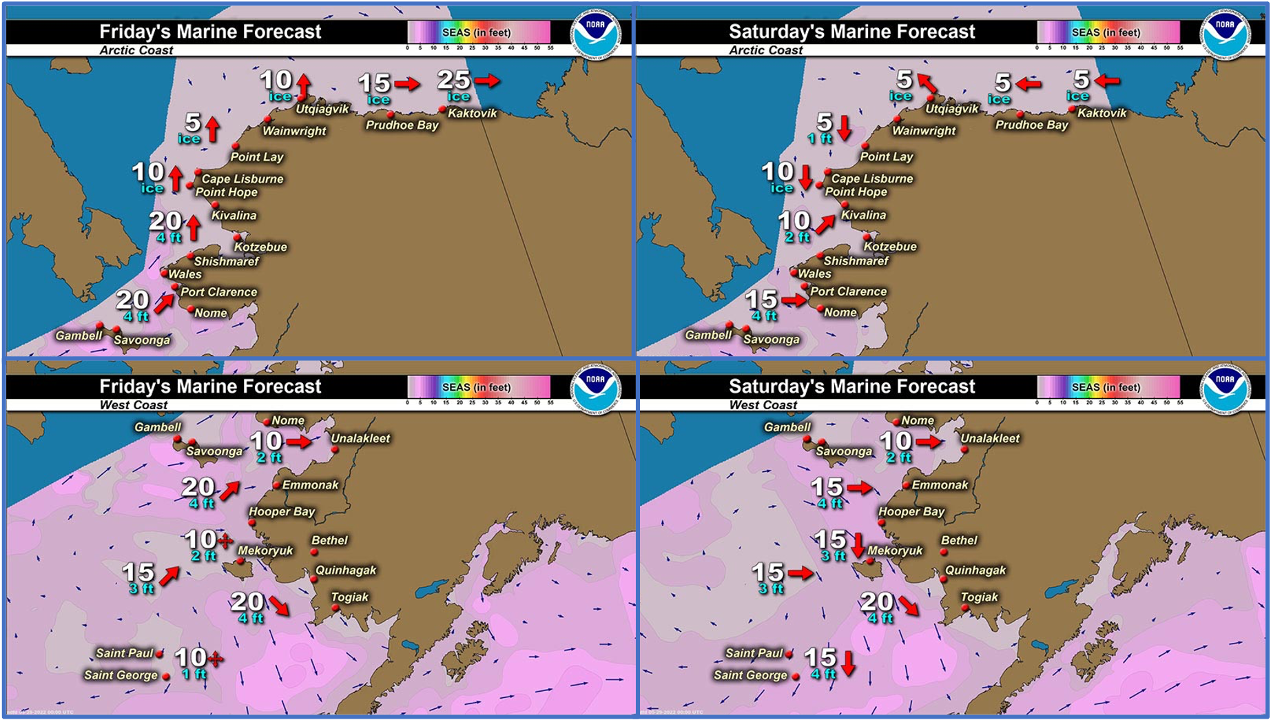
Marine forecast for the West Coast and Arctic Coast
Remote Sensing Images


Observations and Comments
Observations of Sea Ice Development
Observations from Savoonga
Thursday, 26 May 2022 – Aqef Waghiyi
This week few boats got qasiqaq and female walrus and most boats got bull walrus and young bearded seals. Some went 49 miles east northeast and some went 34 miles north and some went 27 miles northwest.
Observations from Port Clarence, Brevig Mission, and Cape Douglas
Friday, 27 May 2022 – Marcus Barr
Been great, got some walrus beginning of the week and brought my boat home from Cape Douglas.


Observations from Gambell
Sunday, 22 May 2022 – Clarence Irrigoo, Jr.
The first boats that went out got walrus with calves and most of the boats got bearded seals, the first boat that went other side said they seen about 50 orcas heading north. All week we have dense fog and windy.
Friday, 27 May 2022 We are covered with ice at this time.

Shared by the Alaska Ocean Observing System (AOOS) for 25 May–2 June 2022
Visit the SIWO Facebook page @seaiceforwalrus to view this animation showing the predicted movement of ice predicted by the HYbrid Coordinate Ocean Model (HYCOM). Snapshots from the forecast show ice coverage from 0% (black) to 100% (white) and arrows show the relative speed and direction of the ice. A light boundary is drawn at 15% predicted ice cover to highlight the ice edge, but ice may be predicted to extend beyond it. Some bays, lagoons, and areas very close to shore are not covered by the model (Image produced by the Alaska Ocean Observing System / Axiom Data Science).
