
Assessment of Current Ice Conditions Relevant to Distribution and Access of Walrus
Click the name of each community below to view more frequently updated and detailed information from the National Weather Service.
Synopsis High pressure remains over the southern Bering Sea. A polar low north of the Bering Strait moves eastward and weakens Friday, then another polar low will move east toward the Chukchi Sea Saturday through Monday.
Near St. Lawrence Island
Shorefast ice is mainly on the north side of the island and extends up to 5 miles (8km) from shore. A large piece of shorefast ice (18 miles or 30 km long and 8 miles or 13 km wide) broke off east of Savoonga near Camp Iveetok but now appears grounded just a few miles offshore and to the east. While there are large areas of open water around the island, there is open to close pack ice consisting of medium to vast floes mainly off the west and north sides of the island. One main area is just offshore between Booshu Camp and Powooiliak Camp and the other main area is approximately 20 miles (32 km) north of the coast between Gambell and Savoonga. North and east of Savoonga is very open to open pack ice consisting of medium to vast floes.
Nome
The only remaining shorefast ice exists approximately 11 miles (18 km) to the east and west of Sinuk. Near Nome is very open pack ice consisting of medium to big floes within a mile or two (1–3 km) offshore. There is another area of brash ice approximately 12 to 15 miles (19 to 24 km).
Nome port entrance webcam (via AOOS webpage): https://bering-sea.portal.aoos.org/?ls=79875242-e362-65cb-914e-fed20ff9…
Brevig Mission/Port Clarence Area
Shorefast ice remains intact 15 miles (24 km) to the west of Port Clarence and 22 miles to the south of Port Clarence (35 km). There is a large polynya that extends 10 to 15 miles (16 to 24 km) off the shorefast ice. It consists of very open pack ice with small floes. Beyond the polynya is close pack ice consisting of big to giant floes.
Wales to Shishmaref
Shorefast ice extends 25 miles (40 km) to the north of Wales, and 4 miles (6 km) to the north of Shishmaref. Between Wales and 30 miles (48 km) west of Shishmaref, beyond the shorefast ice, there is open to close pack ice, consisting of mainly small to big floes. From 30 miles (48 km) west of Shishmaref east is consolidated ice consisting of medium to giant floes.
Diomede
Shorefast ice between the islands remains intact, extending south around 5 miles (8.5 km) from Diomede. To the south and east is close pack ice consisting of big to giant floes. There is an area of very open to open pack ice to the north of Diomede that extends approximately 11 miles (18 km) north.
Forecast Discussion
Ice Forecast
Sea ice in the Bering Strait region will vary in the direction is drifts due to changing wind directions several times throughout the week as detailed in the wind forecast section. During times of moderate to strong winds, sea ice will generally drift with the main wind direction. During times of light winds, sea ice will drift with local currents and likely won’t drift great distances. Sea ice will continue to melt as well, so sea ice concentrations are expected to decrease overall through the week.


Wind Synopsis
North to NNW winds of 20 to 25 kts (23 to 29 mph) to start Friday morning except for St. Lawrence Island where winds will be variable around 5 kts (6 mph). SW winds 10 to 15 kts (12 to 17 mph) from St. Lawrence Island through the Bering Strait Friday afternoon and evening, while NW winds of 10 to 15 kts (12 to 17 mph) south of the Seward Peninsula. Winds will then increase out of the SW through the Bering Strait Saturday with 20 to 25 kts (23 to 29 mph) at Wales, 10 to 15 kts (12 to 17 mph) at St. Lawrence Island, and 10 to 15 kts (12 to 17 mph) at the northern and southern Seward Peninsula. Winds weaken Sunday and turn out of the NW 15 to 20 kts (17 to 23 mph). Later in the day Sunday, winds will increase out of the north between 20 to 25 kts (23 to 29 mph) through the Strait and 10 to 15 kts (12 to 17 mph) for the Seward Peninsula and St. Lawrence Island. Winds weaken out of the north 5 to 15 kts (6 to 17 mph) on Monday, then turn more westerly and southwesterly into Tuesday. Winds then generally from the west to southwest 10 to 15 kts (12 to 17 mph) Wednesday through Friday, with stronger winds near 20 kts (23 mph) near Wales and Diomede.
Temperature Trend
Highs: Friday through Sunday, highs in the mid 30's with lower 30's at Wales. Slightly cooler Monday with lower 30's at St Lawrence Island and Nome and upper 20's from Bering Strait north. Low 30's Tuesday and Wednesday except mid to upper 30's at Nome. Warming trend Thursday and Friday with 40's for highs possible for Nome and Shishmaref, and middle 30's elsewhere.
Lows: Friday and Saturday, lows in the mid 20's for Nome and St. Lawrence Island, while upper teens to 20's north of the Bering Strait. Upper 20's to low 30's Sunday and Monday for Nome and St. Lawrence Island with low to mid 20's north of the Bering Strait. Slightly cooler Tuesday with temperatures in the lower to mid 20's. Gradual warming trend Wednesday, Thursday, and Friday with lows in the mid to upper 20's at the Bering Strait and Shishmaref and low 30's at Nome and St. Lawrence Island.
Daily Weather, Wind, and Temperature Updates
The National Weather Service provides twice-daily, text only updates on the weather, wind, and temperature conditions in specific geographical zones. An interactive weather map for access to other Alaskan zones can be found here: http://weather.gov/anchorage/ice
Higher resolution satellite images and wind maps (wind updated daily) can be viewed here: http://www.weather.gov/afg/SIWO_overview
The Alaska Ocean Observing System shares a variety of weather and sea ice related resources in their Bering Sea Portal at https://bering-sea.portal.aoos.org/.
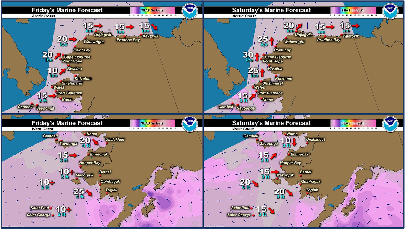
Marine forecast for the West Coast and Arctic Coast
Remote Sensing Images


Observations and Comments
Observations of Sea Ice Development
Observations from Shishmaref
Tuesday, 10 May 2022 – Curtis Nayokpuk
Ducks and little birds just showing up. Cold Northerly winds and blowing snow past couple days, clear sunny this AM. No one out on the sea ice yet. South wind FC so may see new open leads in a day for hunters to scout routes out to ice edge.
Observations from Savoonga
Thursday, 12 May 2022 – Aqef Waghiyi
People are going boating. Couple days ago boats got young and bull walrus. Probably gonna get some today too. Little bit windy but good enough to go. People are already out. Some people are still getting ready to go.
Observations from Diomede
Monday, 10 May 2022 – Marty Eeleengayouq Ozenna
Today were about 0-5 knots wsw both side opening closing and clear blue skys.
UPDATE: Wednesday, 11 May 2022
These might have been last pictures of the year and no ice to the south of Diomede just out west and nothing but shore ice from point of Wales to Nome and far out towards King Island n west of it, so best to go north not west for the surrounding villages of Diomede.


Observations from Gambell
Friday, 13 May 2022 – Clarence Irrigoo, Jr.
Migration of sea mammals are going, see them not to far from Gambell. See females with their young. Most of the boats got walrus and bearded seals. The ice we have lots of game.


Observations from Port Clarence, Brevig Mission, and Cape Douglas
Friday, 13 May 2022 – Marcus Barr
Fast ice broke off about 50 yrds and is closer right at the point of Cape Douglas, so far heard of one crew from Brevig got Walrus about 20 miles out of Cape Douglas, rest of the boats got bearded seal. Been cold at night and early mornings. But more geese and birds are showing up.


Additional Comments Provided by Local Experts and Other Contributors
Visit the SIWO Facebook page @seaiceforwalrus to view this animation showing the predicted movement of ice predicted by the HYbrid Coordinate Ocean Model (HYCOM). Snapshots from the forecast show ice coverage from 0% (black) to 100% (white) and arrows show the relative speed and direction of the ice. A light boundary is drawn at 15% predicted ice cover to highlight the ice edge, but ice may be predicted to extend beyond it. Some bays, lagoons, and areas very close to shore are not covered by the model. (Image produced by the Alaska Ocean Observing System / Axiom Data Science).

Shared by Rick Thoman, ACCAP
Friday, 13 May 2022
Almost cloud-free in the Bering Strait Friday afternoon so here's a zoomed in "truecolor" image courtesy of GINA at UAF. Looks like there is still a thin strip of fast ice from about the Sinuk River up to Cape Woolley. There appears to be water on top of the ice in Imuruk Basin. Ice remains between Little and Big Diomede, while the band of ice from the Gulf of Anadyr now extends just north of St. Lawrence Island to east of Savoonga.
