
Assessment of Current Ice Conditions Relevant to Distribution and Access of Walrus
Click the name of each community below to view more frequently updated and detailed information from the National Weather Service.
Synopsis Strong low pressure remains over the central Bering Sea and will move into the Gulf of Alaska over the weekend while another low traverses the Aleutians through next week.
Near St. Lawrence Island
Shorefast ice on the south side of the island has largely melted. A small amount remains from Powooiliak (Pugughileq) Camp northeastward toward, but not to, Silook Camp around 1–2 miles (1.6–3.2 km) offshore. A large polynya extends from the south coast out to 25 nm. Beyond the polynya is decaying first year ice (small to big floes). Shorefast ice remains largely intact across the north and east sides of the island. Shorefast ice does not extend much offshore Gambell/Savoonga, around 1/2 mile (.8 km), but does extend 1 to 3 miles (1.6¬–4.8 km) between the two locations. Beyond the shorefast ice there is compact to consolidated pack ice of small to medium floes. Beyond the consolidated ice is open water. Between Savoonga and Camp Kulowiye, shorefast ice extends 2–8 miles offshore (3.2–12.8 km). Beyond the shorefast ice is compact to consolidated pack ice composed of mostly small to big floes. Beyond the compact ice is open pack ice consisting of ice cakes to small floes. Shorefast ice remains on the east side of the island up to 5 miles offshore (8 km). Beyond the shorefast is close to very close pack ice that is decaying/melting and difficult to discern form. Open water extends along the west side of the island south of Gambell out to 30 miles offshore (48 km) where decaying close pack ice exists.
Nome
Shorefast ice remains intact up to 3 miles (4.8 km) offshore. Beyond the shorefast ice is close pack ice consisting of small to medium floes.
Nome port entrance webcam (via AOOS webpage): https://bering-sea.portal.aoos.org/?ls=79875242-e362-65cb-914e-fed20ff9…
Brevig Mission/Port Clarence Area
Shorefast ice remains intact 27 miles (43 km) to the west of Port Clarence and 22 miles to the south of Port Clarence (35 km). There is a large polynya that extends up to 20 miles (32 km) off the shorefast ice. There is an area of very close pack ice consisting of small to medium floes that cuts the polynya around 18 miles (28 km) west of Port Clarence.
Wales to Shishmaref
Shorefast ice extends 30 miles (48 km) to the north of Wales, and 18 miles (29 km) to the north of Shishmaref. Between Wales and Shishmaref, there is very close pack ice consisting of small to medium floes. North of Shishmaref beyond the shorefast ice, the polynya has filled in with very close pack ice consisting of small to medium floes. There is a polynya to the west and northwest of Wales that is mostly open water.
Diomede
Shorefast ice between the islands remains intact. Around the islands is very close pack ice consisting of medium to big floes. Around 12 miles (20 km) to the east of Little Diomede is a polynya that extends to Wales.
Forecast Discussion
Ice Forecast
Expect the polynya offshore Port Clarence to continue to remain open under northerly winds. These winds will likely extend the polynya all the way to Nome/Port Safety through next week. The continued northerly wind will put the shorefast ice to the south of Diomede at risk of breaking off. Ice will continue to consolidate against the shorefast to the north of St. Lawrence Island, especially east of Savoonga. The bulk of the remaining Bering Strait region's pack ice will continue to stream around the east side of St. Lawrence Island. The polynya on the south side of St. Lawrence Island will remain and grow, limited by the pack ice coming around the island from the north. The shorefast ice around Nome should hold fast despite the northerly winds.


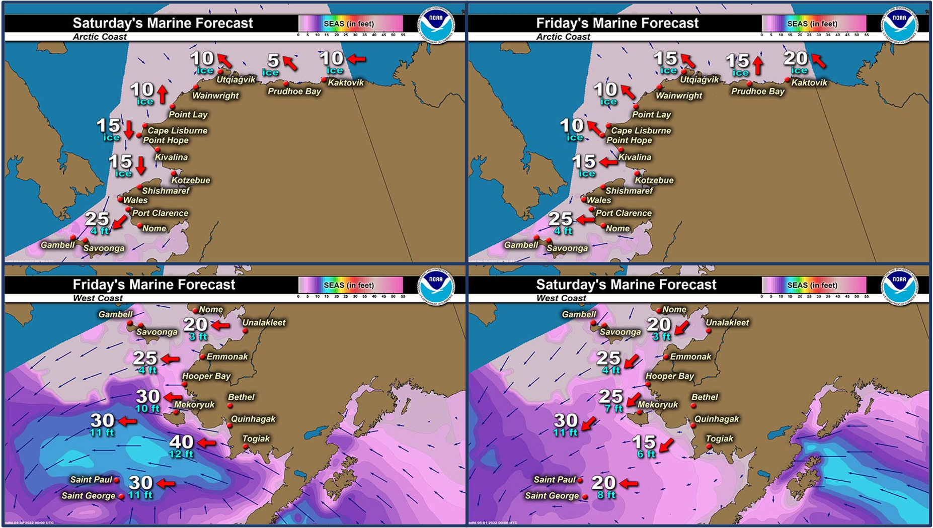
Wind Synopsis
East to northeast winds of 15–25 mph (13–21 kts) will continue across the Bering Strait, Seward Peninsula Coast, and St. Lawrence Island regions on Friday and Saturday. Winds will gradually switch to out of the north to northeast across the area on Sunday (May 1st), and increase to 25–35 mph (21–30kts) through the Bering Strait to St. Lawrence Island, while weaker winds of 15–25 mph (13–21 kts) continue for other areas like Shishmaref, Brevig Mission, and Nome. Winds across the area will not change much through Wednesday (May 4th), but will then gradually decrease to 15–25 mph (13–21 kts) or weaker on Thursday and Friday (May 5–6).
Temperature Trend
The warmest temperatures for the forecast period will be this Friday and Saturday (April 29–30), with highs in the upper 30s for the Bering Strait and St. Lawrence Island, and the low 40s for Brevig Mission and Nome, with overnight lows for all areas in the upper 20s to low 30s. Temperatures will then cool a few degrees across the area as the winds change to out of the north on Sunday (May 1st), and remain that way until next Friday (May 6th). So, for Sunday to Friday (May 1–6) expect most areas in the region to see highs in the low to mid 30s, and lows in the mid to upper 20s. Wales to Shishmaref will see slightly cooler temperatures (highs near 30, lows near 20) while Brevig Mission to Nome will see slightly warmer temperatures (highs in the upper 30s, lows in the upper 20s).
Daily Weather, Wind, and Temperature Updates
The National Weather Service provides twice-daily, text only updates on the weather, wind, and temperature conditions in specific geographical zones. An interactive weather map for access to other Alaskan zones can be found here: http://weather.gov/anchorage/ice
Higher resolution satellite images and wind maps (wind updated daily) can be viewed here: http://www.weather.gov/afg/SIWO_overview
The Alaska Ocean Observing System shares a variety of weather and sea ice related resources in their Bering Sea Portal at https://bering-sea.portal.aoos.org/.
Marine forecast for the West Coast and Arctic Coast
Remote Sensing Images


Observations and Comments
Observations of Sea Ice Development
Observations from Port Clarence and Brevig Mission
Friday, 29 April 2022 – Marcus Barr
Ice conditions near Cape Douglas, snow melting on top of the shorefast ice and cracks are showing. Looked like a chunk of ice broke off since last week. Tundra is bare and lakes and ponds are melted.


Observations from Gambell
Friday, 29 April 2022 – Clarence Irrigoo, Jr.
Windy since Wed. 27 Apr, the one that went on 25/26 Apr got walrus and bearded seals.


Observations from Savoonga
Friday, 29 April 2022 – Aqef Waghiyi
Nobody went boating this week. We’re closed in, but some people got their boats and stuff ready so whenever we get a chance everybody’s gonna go boating. Everybody picked up their gear to south side, so I guess whaling is over. Kinda breezy over here.
UPDATE: 5:00 p.m. AKT - Four boats just went out. One of the boats got walrus. Weather cleared up.
Additional Comments Provided by Local Experts and Other Contributors
Shared by the Alaska Ocean Observing System (AOOS) for 27 April – 5 May 2022
Visit the SIWO Facebook page @seaiceforwalrus to view this animation showing the predicted movement of ice predicted by the HYbrid Coordinate Ocean Model (HYCOM). Snapshots from the forecast show ice coverage from 0% (black) to 100% (white) and arrows show the relative speed and direction of the ice. A light boundary is drawn at 15% predicted ice cover to highlight the ice edge, but ice may be predicted to extend beyond it. Some bays, lagoons, and areas very close to shore are not covered by the model. (Image produced by the Alaska Ocean Observing System / Axiom Data Science)
