
Assessment of Current Ice Conditions Relevant to Distribution and Access of Walrus
Click the name of each community below to view more frequently updated and detailed information from the National Weather Service.
Synopsis A strong low pressure will traverse the Aleutians, moving into the Gulf of Alaska on Saturday. A Kamchatka low will send a front into the western Bering Sea on Sunday/Monday. The Bering Strait/Norton Sound area will remain under either weak low pressure from the south or weak high pressure from the north through next week.
Near St. Lawrence Island
Shorefast ice on the south side of the island has largely melted and broken off due to wind/wave action. A small amount remains from Powooiliak Camp (Pugughileq) northeastward toward but not to Silook Camp around 1–2 miles (1.6–3.2 km) offshore. Otherwise, off the south of the island is very open to open pack ice comprised of decaying first year ice (small to big floes). Shorefast ice remains largely intact across the north and east sides of the island. Shorefast ice does not extend much offshore Gambell/Savoonga, around 1/2 mile (.8 km), but does extend 1 to 3 miles (1.6–4.8 km) between the two locations. Beyond the shorefast ice, there is close to very close pack ice comprised of small to medium floes. Between Savoonga and Camp Kulowiye, shorefast ice extends 2–8 miles offshore (3.2–12.8 km). Beyond the shorefast ice is very open to open pack ice comprised of mostly small to big floes, but does include some vast to giant floes further offshore. Shorefast ice remains on the east side of the island up to 5 miles offshore (8 km). Beyond the shorefast is close to very close pack ice that is decaying/melting and difficult to discern form. Open water extends along the west side of the island south of Gambell out to 10 to 20 miles offshore (16 to 32 km) where decaying close pack ice exists.
Nome
This area has not yet begun for the 2022 season.
Nome port entrance webcam (via AOOS webpage): https://bering-sea.portal.aoos.org/?ls=79875242-e362-65cb-914e-fed20ff9…
Brevig Mission/Port Clarence Area
This area has not yet begun for the 2022 season.
Wales to Shishmaref
Shorefast ice extends 30 miles (48 km) to the north of Wales, and 18 miles (29 km) to the north of Shishmaref. Between Wales and Shishmaref, there is very close pack ice comprised of small to medium floes, with some big floes to the west of Shishmaref. North of Shishmaref beyond the shorefast ice is a large polynya extending to Cape Krusenstern. Within the polynya is an area of open pack ice with small to medium floes.
Diomede
Shorefast ice between the islands remains intact, however the ice to the north of Little Diomede did break off in the last week. Now a small polynya exists with open water extending up to 5 miles (8 km) offshore. Otherwise, around the islands is very close pack ice consisting of medium to giant floes. Around 13 miles (20 km) to the east of Little Diomede is a stream of younger ice from a previous polynya. 16 miles (25 km) to the west of Big Diomede is an area of very open pack ice with medium to big floes.
Forecast Discussion
Ice Forecast
Generally lighter north winds will persist through the next week which will bring the pack southward in most locations. Expect the polynya between Shishmaref and Espenberg to at least partially close as pack ice consolidates against the shorefast, especially closer to Shishmaref. The polynya between Espenberg and Cape Krusenstern should persist. The polynya to the north of Little Diomede will quickly be replaced by very close pack ice. A polynya should open on the south side of the Diomedes beyond the shorefast ice. The wind should not be strong enough to disrupt the shorefast ice, however the north winds do make shorefast breakoff a possibility. For St. Lawrence Island, expect the higher concentration pack ice to the north to compact against the north side of the island. However, there is a large area of open water/very open pack ice west of Savoonga that could remain through early next week. The greater chance for close to very close pack ice to compact against the coast is from Savoonga eastward. The northerly winds should open a large polynya across the south of St. Lawrence Island.


Wind Synopsis
A low pressure system situated southwest of the Aleutian Islands will produce northeasterly winds of 13 kts (15 mph) Friday, April 22nd through Sunday, April 24th. These winds will briefly shift northwesterly on Sunday, April 24th through Monday, April 25th, before veering northeasterly as another low pressure system propagates from the west & south of the area. Wind speeds will remain consistently between 8 to 13 kts (10 to 15 mph) throughout the forecast period (Friday, April 22nd to Friday, April 29th).
Temperature Trend
High temperatures at St. Lawrence Island will be 25 above zero to 30 above zero, with low temperatures in the 20s above zero, for the entirety of the forecast period (Friday, April 22nd to Friday, April 29th). Temperatures will be slightly colder in the Bering Strait compared to St. Lawrence Island for the first few days of the forecast period. From Friday, April 22nd to Sunday, April 24th, high temperatures through the Bering Strait will be 20 above zero to 25 above zero, with low temperatures 15 above zero to 20 above zero. From Monday, April 25th to Friday, April 29th, high temperatures will increase slightly to 25 above zero to 30 above zero, with low temperatures increasing slightly to 20 above zero to 25 above zero.
Daily Weather, Wind, and Temperature Updates
The National Weather Service provides twice-daily, text only updates on the weather, wind, and temperature conditions in specific geographical zones. An interactive weather map for access to other Alaskan zones can be found here: http://weather.gov/anchorage/ice
Higher resolution satellite images and wind maps (wind updated daily) can be viewed here: http://www.weather.gov/afg/SIWO_overview
The Alaska Ocean Observing System shares a variety of weather and sea ice related resources in their Bering Sea Portal at https://bering-sea.portal.aoos.org/.
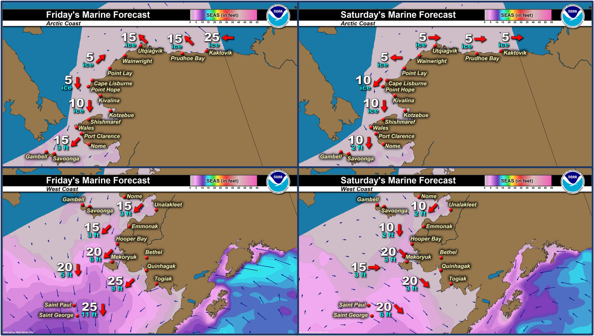
Marine forecast for the West Coast and Arctic Coast
Remote Sensing Images


Observations and Comments
Observations of Sea Ice Development
Observations from Savoonga
Thursday, 21 April 2022 – Aqef Waghiyi
Last week people went boating and got walrus and seal. On Friday too a couple boats also got walrus and bearded seal. On the 20th they saw a whale down at south side. They’re still boating down south not too far out. Further out it’s kinda choppy so they’re staying close to shore.
Wednesday, 20 April 2022 – David Akeya


Observations from Gambell
Friday, 22 April 2022 – Clarence Irrigoo, Jr.
The ice is getting smaller, some boats are harvesting some walrus and seals. Some game are on ice and some in the water.


 and mother (in water) near Gambell on Wednesday, 20 April 2022.")
Observations from Wales
22 April 2022 – Robert Tokeinna, Jr.
Hello from Wales. This past week, a lot of water is showing up on surfaces. I heard Sea Gulls and have seen Snow Birds with spring in full swing. Over flow on Village Creek ice and overflow at the water hole continues to progress. There is an open lead to far as the eye can see. A local teacher on a hike says there is ice south of Wales as far as the ice can see with open leads towards York Mountains. The weather has been a mild 30 degrees to cool teens with prominent northeast winds with variable winds last weekend ranging calm winds to 30 mph gust to 40. This trend of weather seems to be all this week while warming up as southerly winds come towards us. If this keeps up, we may see the ice move and shrink a lot faster. More to come soon.


UPDATE - Sunday, 24 April 2022
I took these pictures yesterday on a ride on our mountain. One looking towards Northwest of our community and the other looking towards York Mountains taken above Tin City. Great photos of the ice and it progression into spring. I wanted to share you these.


Observations from Diomede
Friday, 22 April 2022 – Marty Eeleengayouq Ozenna
We have clear blue skies, sunshine 15–20 knots northeast, both sides seem to be opening closing.


Observations from Port Clarence and Brevig Mission
Friday, 22 April 2022 – Marcus Barr
First report of the season from Cape Douglas, about 28 miles south of Brevig Mission. Spring is in the air, snow melting quick and creeks starting to flow. Seagulls were here for about a week. Rough shorefast ice going out to the ice edge, which is about 4 miles out from the beach. Cracks were showing and some seals seen sunbathing on the ice.


Additional Comments Provided by Local Experts and Other Contributors
Shared by the Alaska Ocean Observing System (AOOS) for 20–28 April 2022
Visit the SIWO Facebook page @seaiceforwalrus to view this animation showing the predicted movement of ice predicted by the HYbrid Coordinate Ocean Model (HYCOM). Snapshots from the forecast show ice coverage from 0% (black) to 100% (white) and arrows show the relative speed and direction of the ice. A light boundary is drawn at 15% predicted ice cover to highlight the ice edge, but ice may be predicted to extend beyond it. Some bays, lagoons, and areas very close to shore are not covered by the model. (Image produced by the Alaska Ocean Observing System / Axiom Data Science).

Shared by Rick Thoman, ACCAP
Wednesday, 20 April 2022
Clear skies over nearly all of western Alaska Tuesday allows for spectacular Truecolor satellite images. This two are from the same satellite pass, just one is zoomed in and one to give to the "full" Bering Sea view. This would be an impressive amount of open water if it was mid-May, much less on April 19.

