
Assessment of Current Ice Conditions Relevant to Distribution and Access of Walrus
Click the name of each community below to view more frequently updated and detailed information from the National Weather Service.
Synopsis Low pressure over the southwestern Bering Sea will move toward St. Matthew Island through Saturday, then weaken through Monday. Another low will track northeast toward the western Aleutian Islands on Monday.
Near St. Lawrence Island
Shorefast ice extends up to 6 miles (10 km) from shore along the north, east, and south sides of the island. Beyond the shorefast ice along the north side of the island from Savoonga east, compact pack ice exists consisting of vast to giant floes. West of Savoonga is close pack ice consisting of big to giant floes. There is a polynya extending up to 23 miles (37 km) from the west coast of the island. Along the south side of the island, shorefast ice generally runs 2 to 3 miles (3 to 5 km) offshore. There is a smaller polynya off the south side of the island that extends up to 5 miles (8 km) from the shorefast ice, and beyond the polynya is extensive, very close pack ice consisting of small to big floes. Any older/thicker floes are off the east/west sides of the island.
Nome
This area has not yet begun for the 2022 season.
Nome port entrance webcam (via AOOS webpage): https://bering-sea.portal.aoos.org/?ls=79875242-e362-65cb-914e-fed20ff9…
Brevig Mission/Port Clarence Area
This area has not yet begun for the 2022 season.
Wales to Shishmaref
Shorefast ice extends 29 miles (47 km) to the north of Wales, and 18 miles (29 km) to the north of Shishmaref. Beyond the shorefast ice, there are some small polynyas that extend up to 5 miles (8 km), and otherwise very close pack ice to consolidated ice with medium to giant floes.
Diomede
Shorefast ice exists between the islands and extends to both the north and south 6 miles (9.6 km) from a centerpoint between Big/Little Diomede. Beyond the shorefast ice, as well as west/east of the islands, close to very close pack ice exists with big to vast floes. While some older/thicker floes are around the east and southeast side of the island, the ice to the southeast is predominately young ice from a previous polynya.
Forecast Discussion
Ice Forecast
Ice will generally move westward over the next week with the persistent east to northeast winds. For St. Lawrence Island, expect the polynya off the west side of the island to expand, though there will likely be some new sea-ice formation within the polynya. Near Diomede, expect the sea ice to compact against the east side of the island and a polynya to form off the shorefast ice near Wales. Some shorefast ice near Wales could break off during some of the stronger easterly winds.


Wind Synopsis
A strong low near the Aleutians will produce northeast to east winds, 20 to 30 kts through the weekend, with winds diminishing to 10 to 20 kts Monday and Tuesday, 5 to 15 kts Wednesday, then increasing to 10 to 20 kts Thursday and Friday.
Temperature Trend
Highs in the 30s through Monday with lows in the 20s. Cooling trend the remainder of the week as high pressure pushes southwest into the area, and high temperatures will be in the 20s to around 30, while lows will be in the teens to mid-20s with the warmer temperatures on St. Lawrence Island.
Daily Weather, Wind, and Temperature Updates
The National Weather Service provides twice-daily, text only updates on the weather, wind, and temperature conditions in specific geographical zones. An interactive weather map for access to other Alaskan zones can be found here: http://weather.gov/anchorage/ice
Higher resolution satellite images and wind maps (wind updated daily) can be viewed here: http://www.weather.gov/afg/SIWO_overview
The Alaska Ocean Observing System shares a variety of weather and sea ice related resources in their Bering Sea Portal at https://bering-sea.portal.aoos.org/.
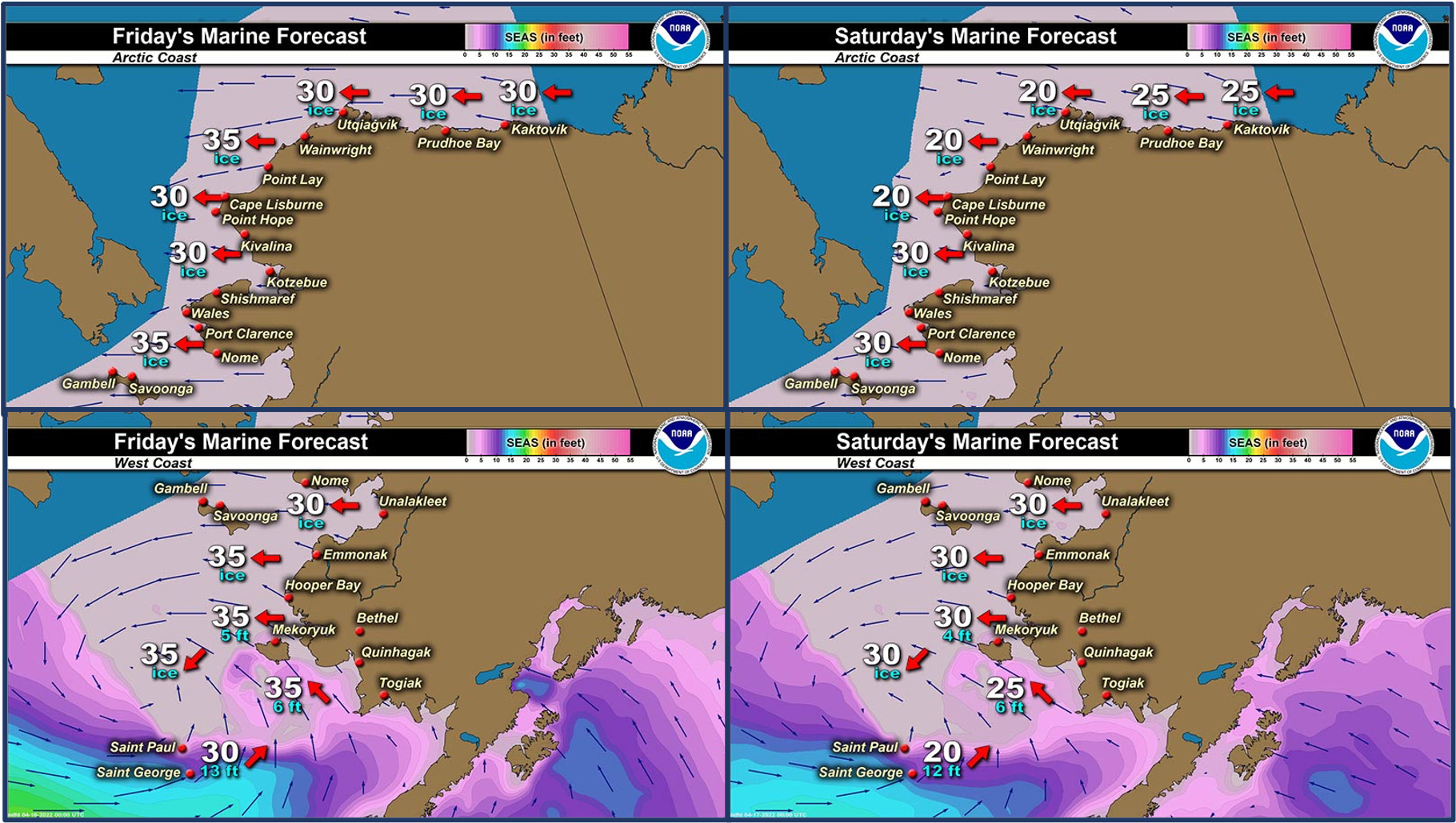
Marine forecast for the West Coast and Arctic Coast
Remote Sensing Images


Observations and Comments
Observations of Sea Ice Development
Observations from Diomede
Monday, 11 April 2022 – Marty Eeleengayouq Ozenna
South side pictures above the crabbing area, still closed in. Winds SSW 10-20 knots, clear skies.


UPDATE: Friday 15 April 2022 - Yesterday we had a bit of ground storm off n on during the day and some showers wet snow n slight drizzle.
Observations from Savoonga
Thursday, 14 April 2022 – Aqef Waghiyi
No open water down south. Everybody came back last Thursday. People got 1-2 crab. They seen one whale. Shore ice still around, about half mile out or mile out there’s open water. Pretty windy right now. Today it’s 31 degrees and snow mixed with rain out there.
Friday, 15 April 2022 – David Akeya
Opening up out of Savoonga, AK plenty of walrus out there.


Observations from Gambell
Thursday, 14 April 2022 – Clarence Irrigoo, Jr.
On April 11, Alvin Aningayou and crew landed 34ft bowhead.


We have high wind since they got the whale. All that ice is coming out from the north.

Observations from Wales
15 April 2022 – Robert Tokeinna, Jr.
Good Morning from Wales. I got the opportunity to fly from Nome - Shishmaref - Wales with decent weather mostly on Shishmaref side. The ice appear to be the same structured ice that's in front of Wales with open leads north and south of Shishmaref. The creeks and rivers seem to be opening up in between Nome, Shishmaref, and Wales with overflow in the Imuruk(sp) Basin and Pilgrim River drainage. There were signs of water glistening from creeks and rivers. The shorefast ice appears to be holding up after a warm week of weather and rain last night. There's ice from far as the eye can see compared to years past where it was almost ice free in the past. As we made our way towards Wales, it got greyer weather and more white out as we landed in Wales. The ice appeared to be jammed up and pushing north as we are expecting southerly winds. Very warm weather in Nome while there, I got to glimpse at the Shorefast Ice in Nome with activities appeared to be local crabbers and snowmachine enthusiasts riding abroad. Spring thaw is here and in full action from what I can see from the air. More to come next week.


Observations from Shishmaref
Sunday, 17 April 2022 – Curtis Nayokpuk
Downloaded some new (4-15-2022) Polar View ice maps and white areas north of Shishmaref confirms Robert T. Jr. (Wales, comments on his flight route) of recent brisk easterly winds showing open water alongshore fast ice.


Additional Comments Provided by Local Experts and Other Contributors
Visit the SIWO Facebook page @seaiceforwalrus to view this animation showing the predicted movement of ice predicted by the HYbrid Coordinate Ocean Model (HYCOM). Snapshots from the forecast show ice coverage from 0% (black) to 100% (white) and arrows show the relative speed and direction of the ice. A light boundary is drawn at 15% predicted ice cover to highlight the ice edge, but ice may be predicted to extend beyond it. Some bays, lagoons, and areas very close to shore are not covered by the model. (Image produced by the Alaska Ocean Observing System / Axiom Data Science)
