
Assessment of Current Ice Conditions Relevant to Distribution and Access of Walrus
Click the name of each community below to view more frequently updated and detailed information from the National Weather Service.
Synopsis A front draped from west to east across the Bering Sea will dissipate as the associated low pressure weakens and move into the Gulf of Anadyr. Broad and weak low pressure will remain over much of the Bering Sea through the week, coupled with Arctic high pressure to keep the area in a light northerly wind regime.
Near St. Lawrence Island
Shorefast ice exists on the north, east, and south sides of the island. From Gambell to Savoonga, shorefast extends up to 4 miles (6 km) offshore. The largest extent of shorefast ice lies between Ataakas Camp and Alngeeyak, up to 8.5 miles (13.6 km) offshore. Along the south side of the island, shorefast ice generally runs 2 to 3 miles (3 to 5 km) offshore. Beyond the shorefast ice along the north side of the island, compact pack ice exists consisting of vast to giant floes.
Nome
This area has not yet begun for the 2022 season.
Nome port entrance webcam (via AOOS webpage): https://bering-sea.portal.aoos.org/?ls=79875242-e362-65cb-914e-fed20ff9…
Brevig Mission/Port Clarence Area
This area has not yet begun for the 2022 season.
Wales to Shishmaref
Shorefast ice extends 50 miles (80 km) to the north of Wales, and 18 miles (29 km) to the north of Shishmaref. Easterly winds are currently (Wednesday 3/31) opening up a small polynya (1 to 3 miles) off the shorefast ice. Beyond the shorefast ice and polynya exists very close pack ice to consolidated ice with big to giant floes.
Diomede
Shorefast ice exists between the islands and extends to both the north and south 6 miles (9.6 km) from a center point between Big/Little Diomede. Beyond the shorefast ice, as well as west/east of the islands, close pack ice exists with big to vast floes. A large polynya (quickly filling with new ice) is growing to the west of Wales/Port Clarence with the edge 9 miles to the east of Little Diomede.
Forecast Discussion
Ice Forecast
Ice will generally move southwestward through the week 25 to 40 nm. Polynyas will continue to open up along south facing coastlines and compact against north facing coastlines.


Wind Synopsis
Strong easterly winds of 25 kts (29 mph) with gusts to 35 kts (40mph) will decrease 15 kts (17 mph) Thursday night and turn northeasterly on Friday April 1st. These northeasterly winds will increase to 25 kts (29 mph) on Friday night, then persist at 20 to 25 kts (23 to 29 mph) through Sunday afternoon April 3rd with lighter winds 15 to 20 kts (17 to 23 mph) from Savoonga southeast. On Sunday afternoon April 3rd, winds will turn northerly and strengthen to 25 kts (29 mph) through Thursday April 7th.
Temperature Trend
High temperatures in the 30s above zero for St. Lawrence Island and the 20s above zero for the Bering Strait on Thursday March 31st will cool to the 20s above zero for St. Lawrence Island on Friday April 1st and to the teens above zero for the Bering Strait. Highs will continue to cool and by Sunday April 3rd highs will be in the teens above zero for St. Lawrence Island and the single digits above zero for the Bering Strait. Highs in the single digits above zero will persist through Thursday April 7th near the Bering Strait, with highs near 10 above zero near St. Lawrence Island. Overnight lows will cool to the single digits above zero over the area by Saturday morning April 2nd and to the single digits below zero by Monday morning April 4th. These temperatures will persist through next week, with a slight warming trend possible on Thursday April 7th and Friday April 8th.
Daily Weather, Wind, and Temperature Updates
The National Weather Service provides twice-daily, text only updates on the weather, wind, and temperature conditions in specific geographical zones. An interactive weather map for access to other Alaskan zones can be found here: http://weather.gov/anchorage/ice
Higher resolution satellite images and wind maps (wind updated daily) can be viewed here: http://www.weather.gov/afg/SIWO_overview
The Alaska Ocean Observing System shares a variety of weather and sea ice related resources in their Bering Sea Portal at https://bering-sea.portal.aoos.org/.
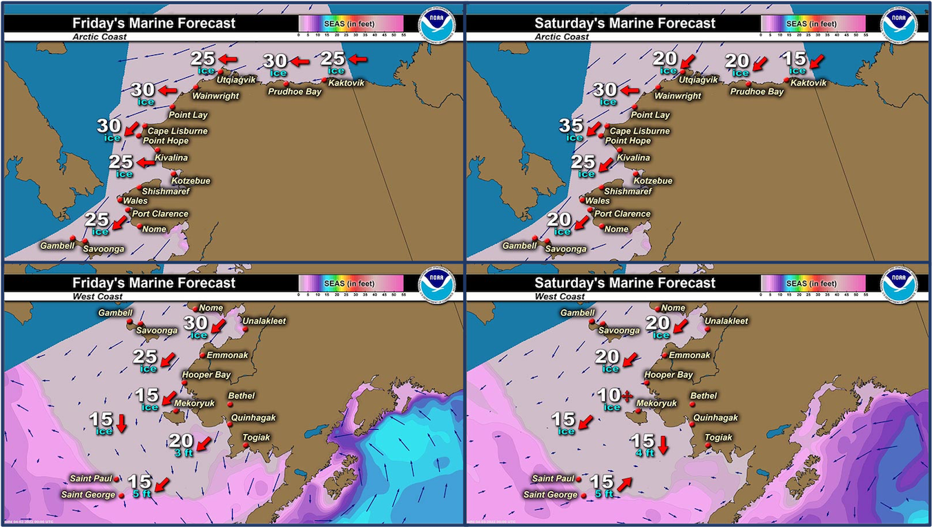
Marine forecast for the West Coast and Arctic Coast
Remote Sensing Images


Observations and Comments
Observations of Sea Ice Development
Observations from Savoonga
31 March 2022 – Aqef Waghiyi
Nobody went nowhere this past week. Whiteout conditions and kinda windy. 4-5 days ago people went crabbing down south. They got a few. Some people got 7, some got 3, two people from Gambell got 4-5 crab. Sunday or Monday people went down south to go crabbing. There was open water down south. One of the boats got a bearded seal down south.
Observations from Wales
31 March 2022 – Robert Tokeinna, Jr.
Good Afternoon from Wales. Windy, breezy week and ending with sunny weather. It's a balmy 15 degrees and light 15 from northeast winds. Before today, brisk winds with some drifting snow past couple days. There's open water and more pressure ridges this week. Not too much movement in Wales as it has been windy and overcast. More to come next week.


1 April 2022 - Michael Edward Ahkinga Jr.
Hello, seen some walrus yesterday traveling pond to pond with the young ice that formed. Was seeing pretty healthy dark walrus along with 2 bowhead. There were a few near the ice edge and on the floe ice traveling up north. both small bunches were a few miles off from each other, the healthiest walrus we seen so far.
Observations from Gambell
1 April 2022 – Clarence Irrigoo, Jr.
Still windy yet will go to the beach later. Yesterday evening we have big open water.

UPDATE: 1pm photos 20° NE 20 mph open up in Gambell but very windy.


UPDATE: 8:15 p.m.
Ice from the north going south this evening.


Observations from Diomede
1 April 2022 – Marty Eeleengayouq Ozenna
We’re still closed in on both north n south side of the island and today north north east 20–25 knots clear blue skys sunny.


Additional Comments Provided by Local Experts and Other Contributors
Visit the SIWO Facebook page @seaiceforwalrus to view this animation showing the predicted movement of ice predicted by the HYbrid Coordinate Ocean Model (HYCOM). Snapshots from the forecast show ice coverage from 0% (black) to 100% (white) and arrows show the relative speed and direction of the ice. A light boundary is drawn at 15% predicted ice cover to highlight the ice edge, but ice may be predicted to extend beyond it. Some bays, lagoons, and areas very close to shore are not covered by the model. (Image produced by the Alaska Ocean Observing System / Axiom Data Science)

Shared by Rick Thoman, ACCAP
1 April 2022
Friday early afternoon Truecolor satellite image. This is from the Terra-1 satellite that orbits at about 415 miles above the ground. There are still a lot of clouds between Little Diomede and St. Lawrence Island but Norton Sound and the Yukon delta is cloud free.
