
Assessment of Current Ice Conditions Relevant to Distribution and Access of Walrus
Click the name of each community below to view more frequently updated and detailed information from the National Weather Service.
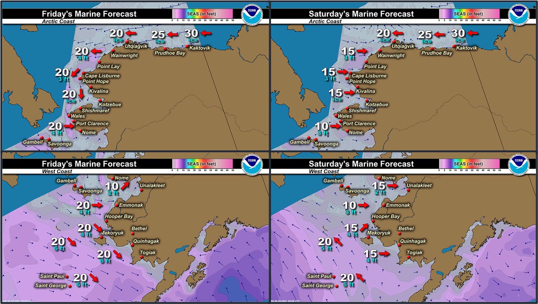
Synopsis – Generally quiet weather until a low moves across the Aleutian Islands starting on Saturday.
Near St. Lawrence Island
There is shorefast ice, mainly on the north side of St. Lawrence Island, generally extending 1 to 5 miles offshore. Beyond the shorefast ice on the north side of the island is consolidated to compact pack ice consisting of medium to vast floes. There is a polynya consisting of open water beyond the shorefast ice between Gambell and Savoonga that is 5 to 15 miles wide. There is compact pack ice 2 miles west of Gambell, and open water south of the island. To the east of the island is open pack ice that extends 20 to 25 miles offshore.
Nome
The only remaining shorefast ice in this area is near Sinuk and it extends up to 2 miles offshore. There is an area of open water south of Nome, extending 16 to 20 miles offshore. Close pack ice exists south of the open water, extending approximately 45 miles south, consisting of small ice cakes to medium floes.
Brevig Mission/Port Clarence Area
Shorefast ice remains intact and extends approximately 22 miles west/southwest of Brevig Mission. There is then a polynya that extends off the shorefast ice up to 30 miles, then close pack ice consisting of medium to vast floes.
Wales to Shishmaref
Shorefast ice extends up to 2.5 miles from the coast. Beyond the shorefast ice is consolidated ice consisting of medium to giant floes. To the west and northwest of Wales, very open pack ice to open water extends up to 7 miles, with close pack ice beyond that.
Diomede
Close pack ice surrounds Little Diomede Island and extends 70 to 80 miles north and south of the island. There is an area of very close pack ice south of the island. From 13 to 20 miles east of the island is an area of open water.
Forecast Discussion
Ice Forecast
Sea ice will generally move with ocean currents through Friday, with the exception of the Bering Strait area where sea ice may drift southward if winds are stronger than the currents. Thinner sea ice between thicker ice floes will continue to melt through the week.


Wind Synopsis
West to northwest winds 5 to 15 kt (6 to 17 mph) on Friday, May 21st will become light and variable around 5 kt (6 mph) on Saturday, May 22nd. Winds will shift to the east-northeast 10 to 15 kt (11 to 17 mph) across the region on Sunday, May 23rd and persist through Tuesday, May 25th. Winds up to 20 kt (23 mph) will occur at times from the Bering Strait to St. Lawrence Island. From Wednesday, May 26th to Friday, May 28th, winds will be mainly north-northwest 5 to 10 kt (6 to 11 mph), except continued stronger northerly winds to 20 kt (23 mph) through the Bering Strait.
Temperature Trend
Temperatures will remain relatively steady through the week. High temperatures Friday, May 21st through Friday, May 28th will be mainly in the upper 30s to mid-40s, except in the mid 40's to lower 50's from Teller to Nome. Overnight low temperatures will be in the 30's.
Daily Weather, Wind, and Temperature Updates
The National Weather Service provides twice-daily, text only updates on the weather, wind, and temperature conditions in specific geographical zones. An interactive weather map for access to other Alaskan zones can be found here: http://weather.gov/anchorage/ice
Higher resolution satellite images and wind maps (wind updated daily) can be viewed here: http://www.weather.gov/afg/SIWO_overview
Marine forecast for the West Coast and Arctic Coast
Remote Sensing Images


Observations and Comments
Observations of Sea Ice Development
Observations from Diomede
Monday, 17 May 2021 – Marty Eeleengayouq Ozenna
South side has ice that came from the west n south of us, also the ice that went behind Big Diomede came back to the north side of us an were still holding on the southern side of the island and north side. Couple days ago we went out sank 1 sank a bearded seal later that night 3 guys went back out stayed out all day an night but went out got 3 females. We saw a boat to the outside of the ice to the west, might have been 1 of the villages chasing the ice or was Russian hunters. We’re rotting from middle to outside the ice edge.


Observations from Savoonga
20 May 2021 – Aqef Waghiyi
People are out boating today as we speak. I don’t know what they all got yet but heard some got walrus and seals. It’s calm out, keeps getting foggy and then clears up. The fog is not too thick. Thin fog.
Observations from Gambell
20 May 2021 – Clarence Irrigoo, Jr.
Ice came in pretty close, most of the boats that went out got their games.


Observations from Port Clarence and Brevig Mission
20 May 2021 – Marcus Barr
Cracks along the beach in front of Brevig are pretty wide. Water had gone down from top of the ice. Ice between Port Clarence and Brevig is getting rotten and soft. Most hunters have their boats about 8-10 miles west of Brevig and waiting for an open lead.


Observations from Nome
21 May 2021 – Boogles Johnson
Currently there are little pieces of ice here & there but the pack has left. You can see off in the distance that there’s still ice out on the horizon when we don’t have fog. This Sunday 5/16 cooled off and all week Nome was rather cool slowing the spring thaw. Thursday it finally warmed up and today is drizzling overcast.

UPDATE:
Yesterday 2 boats went out, both went out in the 50-70 mile range south west of Nome. There's still ice out there now it's time to use the big boats that couldn't go over the ice.
Additional Comments Provided by Local Experts and Other Contributors
Shared by Rick Thoman, ACCAP
19 May 2021
Plenty of clouds over Norton Sound Wednesday afternoon but they are thin enough to allow the false-color image from satellite to show that ice continues to diminish in western Norton Sound, with most of the ice now away from Sledge Island. Ice is also slowly decreasing in southern and eastern Norton Sound. Clouds are too thick to say much about ice in the Bering Strait and around St. Lawrence Island.
