
Assessment of Current Ice Conditions Relevant to Distribution and Access of Walrus
Click the name of each community below to view more frequently updated and detailed information from the National Weather Service.
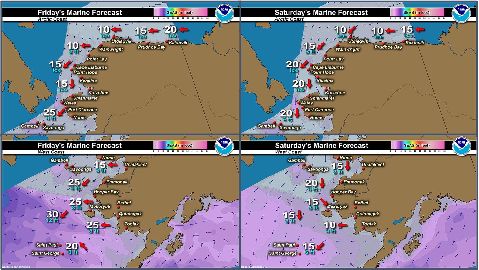
Synopsis – A low will gradually move eastward across the southern Bering Sea through Saturday, then move south into the North Pacific Sunday and Monday.
Near St. Lawrence Island
There is shorefast ice, mainly on the north and east side of St. Lawrence Island, generally extending 1 to 2 miles offshore. Beyond the shorefast ice on the north side of the island is compact pack ice to consolidated ice consisting of medium to vast floes. To the east and west of the island is open pack ice that extends 23 miles to the west of the island and 11 miles to the east of the island. To the south of the island is open water extending up to 90 miles.
Nome
Shorefast ice around the Nome area extends up to 2 miles offshore from Sinuk to near Solomon, and up to 7 miles offshore near Cape Rodney out to Sledge Island. There is an area of open pack ice south of Nome, with open water to the west of Dexter and to the east of Cape Nome. Close to very close pack ice exists south of the open water, throughout central and southern Norton Sound with medium to vast floes.
Brevig Mission/Port Clarence Area
Shorefast ice remains intact and extends 23 to 25 miles west/southwest of Brevig Mission. There is a small polynya that extends off the shorefast ice up to 4 miles, then close pack ice consisting of medium to vast floes.
Wales to Shishmaref
Shorefast ice extends up to 2.5 miles from the coast. Beyond the shorefast ice is consolidated ice consisting of medium to giant floes. To the west and northwest of Wales, very open pack ice to open water extends up to 30 miles.
Diomede
Shorefast ice persists between the islands. There is consolidated ice to the north of the shorefast that extends around 2.5 miles. Otherwise, open water extends to the north, east, and south of the island.
Forecast Discussion
Ice Forecast
Continued offshore flow will move the icepack mainly to the southwest, 20 to 30 miles through Thursday May 20th. Polynyas will continue to grow. Thinner sea ice between thicker ice floes will continue to melt through the week.


Wind Synopsis
Norton Sound Region...
Friday, May 15th northeast wind 10 to 15 kts (12–17 mph) becoming northwest Sunday, May 17th in the morning. Wind on Monday, May 18th shifts to west and increases to 15 to 20 kts (17–23 mph) diminishing to southwest 10 to 15 kts (12–17 mph) Tuesday, May 19th in the afternoon. The wind diminishes to variable 5 to 10 kts (6–12 mph) for Wednesday, May 20th then shifts into the east and increases to 15 to 20 kts (17–23 mph) on Thursday, May 21st before diminishing on Friday, May 22nd morning back down to 5 to 10 Kts (6–12 mph) from the southeast.
Bering Strait and Saint Lawrence Island Region...
Friday, May 15th northeast wind 20 to 25 kts diminishing to northwest 15 to 20 kts (17–23 mph) late Sunday, May 17th. Wind on Monday, May 18th becomes variable 5 to 15 kts (6–12 mph) until Thursday, May 21st when early in the morning it begins increasing to northeast 20 to 25 kts (23–27 mph) through Friday.
Temperature Trend
Norton Sound Region...Friday, May 14th through Friday, May 21st maximum temperatures in the 40s. Minimum temperatures in the upper 20s to upper 30s.
Bering Strait Region...Friday, May 14th through Friday, May 21st maximum temperatures in the mid to upper 30s. Minimum temperatures 25 to 30.
St. Lawrence Island Region...Friday, May 14th through Friday, May 21st maximum temperatures in the upper 30s to low 40s.
Daily Weather, Wind, and Temperature Updates
The National Weather Service provides twice-daily, text only updates on the weather, wind, and temperature conditions in specific geographical zones. An interactive weather map for access to other Alaskan zones can be found here: http://weather.gov/anchorage/ice
Higher resolution satellite images and wind maps (wind updated daily) can be viewed here: http://www.weather.gov/afg/SIWO_overview
Marine forecast for the West Coast and Arctic Coast
Remote Sensing Images


Observations and Comments
Observations of Sea Ice Development
Observations from Diomede
Tuesday, 11 May 2021 – Marty Eeleengayouq Ozenna
Took pictures of the north side this morning, still holding but rotting from underneath, also the top is melting away and were still waiting for the weather to die down or the south side to break off more. Couple boats ready.


Observations from Elim to Nome
Monday, 10 May 2021 – Kim Takak
Near Elim, flight from Nome (4 photos).


Flight to Nome around Rocky and towards Nome (6 photos).


Observations from Savoonga
13 May 2021 – Aqef Waghiyi
No good for boating here still. Gambell has been boating almost daily. No walrus yet. Still winter for us here. Few open leads here and there. Shore ice is kinda thin on some parts to go down to the open water. It’s melting pretty fast the past week or so.
14 May 2021 – Aqef Waghiyi
Yesterday few boats went out few hours after you called, and I think all boats got walrus 5 to 8 miles out.
Observations from Gambell
14 May 2021 – Clarence Irrigoo, Jr.
From May 9–12 boats went out got walrus. May 11 was so foggy but 18-20 boats went out. Most of the boats got walrus. Once when we get to the ice 20+ miles out we see all this. See no more ice, only ice is coming from NE.


Observations from Nome
14 May 2021 – Boogles Johnson
The shorefast ice has broken from the shore in Nome today. Our rivers are starting to flow and spring is beautiful. A majority of the spring hunters have been successful in harvesting Ice Seals and Walrus this year. Spring is a little later this year than the past few years but it seems like the thaw has been happening faster than the past few years.


Observations from Port Clarence and Brevig Mission
14 May 2021 – Marcus Barr
Not much of a difference but looks like it's going to break off around by Cape Douglas.
Additional Comments Provided by Local Experts and Other Contributors
Shared by Rick Thoman, ACCAP
14 May 2021
Early Friday morning false-color satellite photo showing the rapidly increasing areas of low elevation snow-free ground on the Seward Peninsula. Notice that from White Mountain/Council eastward, areas with boreal forest show up as a slightly different color than tundra.
