
Assessment of Current Ice Conditions Relevant to Distribution and Access of Walrus
Click the name of each community below to view more frequently updated and detailed information from the National Weather Service.
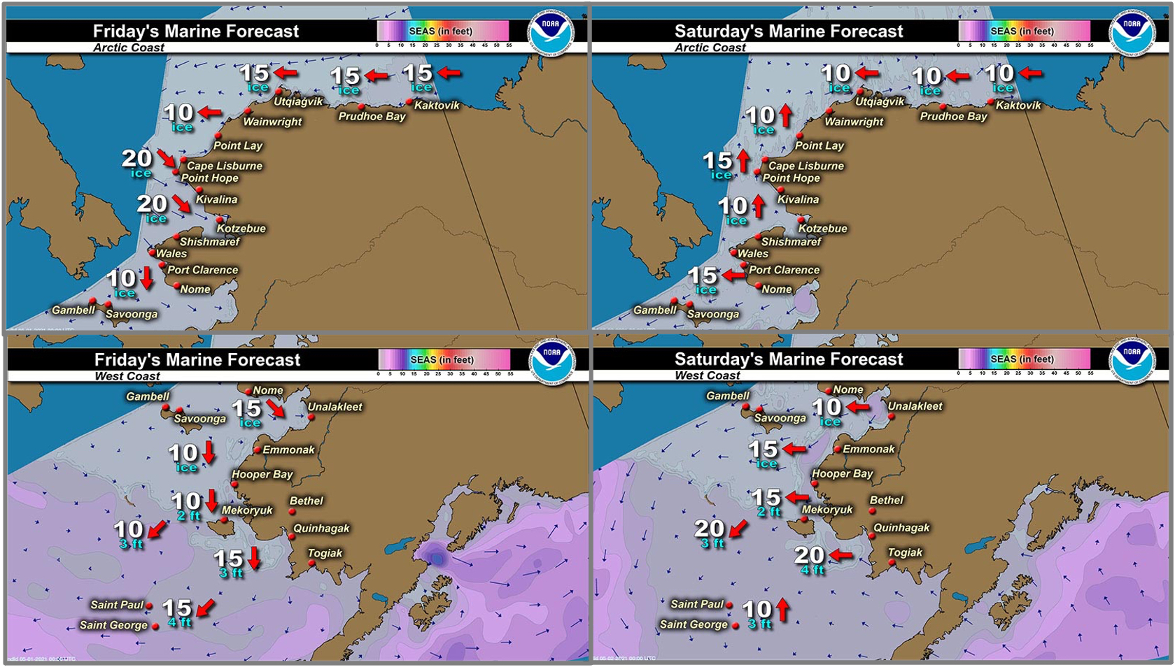
Synopsis – High pressure over the Bering Sea will continue to build in from Siberia. Low pressure over the mainland of Alaska will weaken and drift east. Weak low pressure will develop along the southern Beaufort Sea and northern Chukchi Sea Saturday. A north Pacific low will move into the Bering Sunday and Monday then dissipate through Thursday.
Near St. Lawrence Island
There is shorefast ice on the north, east, and south sides of St. Lawrence Island, however, it looks to be decaying along the east and south sides of the island. On the north and south sides, generally extending 1 to 2 miles offshore, and on the east side, extending 2 to 3 miles offshore. Beyond the shorefast ice on the north and east sides of the island is close pack ice to consolidated ice consisting of medium to vast floes.
There is a polynya south of the island that now only extends 2 miles south of Powooiliak Camp and still around 32 miles south of Siknik Training Camp. Beyond that polynya is close pack ice consisting of medium to vast floes. There is also a polynya off the west coast that stretches 5 miles west of Gambell and 12 miles west of Booshu Camp, with close pack ice consisting of medium to vast floes beyond that.
Nome
Shorefast ice around the Nome area extends up to 2 miles offshore from Sinuk to near Solomon, and up to 7 miles offshore near Cape Rodney out to Sledge Island. There is a polynya offshore the Nome shorefast up to 20 miles. Near Port Safety, the polynya only extends up to 3 miles offshore, and widens again near Solomon up to 20 nm. Beyond the polynya, there is very close pack ice consisting of medium to vast floes.
Brevig Mission/Port Clarence Area
Shorefast ice extends 23 to 25 miles west/southwest of Brevig Mission. There is then a polynya that extends 5 to 7 miles beyond the shorefast ice directly to the south of Port Clarence. Otherwise, the main pack ice is very close pack ice consisting of medium to giant floes.
Wales to Shishmaref
Shorefast ice extends up to 2.5 miles from the coast. Beyond the shorefast ice is very close pack ice to consolidated ice consisting of medium to giant floes.
Diomede
Shorefast ice persists between the islands. There is a polynya that extends up to 5 miles south of the shorefast ice. Otherwise, very close pack ice consisting of big to giant floes surrounds the island.
Forecast Discussion
Ice Forecast
Sea ice will generally move with the tides and currents through Friday, May 7th. Polynyas will continue to grow. Thinner sea ice between thicker ice floes will continue to melt through the week.


Wind Synopsis
Friday, April 30th variable wind less than 10 kts (12 mph) increasing to northeast 15 to 20 kts (17 to 23 mph) by Sunday, May 2nd by mid-day. Wind diminishes to variable less than 10 kts (12 mph) by Tuesday, May 4th. Wind shifts to the north and increases to 10 to 20 kts (17 to 23 mph) on Thursday, May 6th and continues through the end of the forecast.
Temperature Trend
All Regions maximum...
Friday, April 30th through Sunday, May 2nd maximum temperatures ranging from the upper 20s in the Bering Strait region ranging to the upper 30s in Norton Sound. Monday, May 3rd through Friday, May 7th maximum temperatures in the 30s region wide.
All Regions minimum...
Friday, April 30th through Friday, May 7th minimum temperatures will range from the upper teens to upper 20s.
Daily Weather, Wind, and Temperature Updates
The National Weather Service provides twice-daily, text only updates on the weather, wind, and temperature conditions in specific geographical zones. An interactive weather map for access to other Alaskan zones can be found here: http://weather.gov/anchorage/ice
Higher resolution satellite images and wind maps (wind updated daily) can be viewed here: http://www.weather.gov/afg/SIWO_overview
Marine forecast for the West Coast and Arctic Coast
Remote Sensing Images


Observations and Comments
Observations of Sea Ice Development
Observations from Kotlik
26 April 2021 – Jeff Unok
Little open lead where I circled the area if you zoom in can see the Nulato Hills.

Observations from Gambell
27 April 2021 – Clarence Irrigoo, Jr.
This morning some boats are getting ready to hunt. Yesterday boats got bearded and walrus yesterday. The ice about 3 miles out.
Observations from Nome
28 April 2021 – Boogles Johnson
Good morning, the ice is moving in Nome now, today is the first day that you can see the ice moving from the shorefast ice. All last week and this weekend we have had a strong spring thaw. This week the temps are cooling down a bit and there's wind which will move the ice more. Our local hunters are busy getting their boats ready for the spring hunt now that the ice is moving. The photo is the top of the first hill on the Nome-Kugurok road.

Observations from Savoonga
29 April 2021 – Aqef Waghiyi
No open water just a few small open leads here and there. Kinda too foggy to see further out. Can see only a couple of small open leads north of town but can’t see anything further than that. No seal, no game at those two small open leads. There’s two boats at whaling camp trying to get walrus. Don’t know if they had any luck. No update from them yet. Maybe foggy, kinda windy down there. Breezy from the west here. Fog is too thick to be burnt off today.
30 April 2021 – Photo Update


Observations from Port Clarence and Brevig Mission
29 April 2021 – Marcus Barr
Foggy and snow and blowing kept me from doing an accurate ice report.
Observations from Diomede
30 April 2021 – Marty Eeleengayouq Ozenna
Not too much crabbing going on. The wind was a problem then the south opened up pretty good also the north was open a ways out but closed now. It’s coming back in slowly, also there was a few bowheads out swimming or passing also white whales were with them passing as well, but the wind and current was a bit strong to go out but couple hunters went out.


Additional Comments Provided by Local Experts and Other Contributors
Shared by Rick Thoman, ACCAP
29 April 2021
More clouds than not in this NASA image from Wednesday afternoon (April 28) but enough clear skies along the southern Seward Peninsula coast and around St. Lawrence for possibly helpful information. The link for this particular image is here: https://tinyurl.com/3rz7ahc6 and you can zoom in or out.
