
Assessment of Current Ice Conditions Relevant to Distribution and Access of Walrus
Click the name of each community below to view more frequently updated and detailed information from the National Weather Service.
Synopsis – High pressure builds over the Bering Sea through Saturday. A low will move westward across the North Pacific Sunday through Wednesday.
Near St. Lawrence Island
There is shorefast ice on the north, east, and south sides of St. Lawrence Island. On the north side, generally extending 1 to 2 miles offshore, and on the east side, extending 2 to 5 miles offshore. The south side of the island has minimal shorefast ice, mainly stretching from Powooiliak (Pugughileq) Camp to Silook Camp as well as at Siknik Training Camp and extending up to 3 miles offshore. Beyond the shorefast ice on the north and east sides of the island is very close pack ice to consolidated ice consisting of medium to vast floes.
There is a polynya south of the island that extends up to 12 miles from the southern coast, though it is re-freezing quickly. Beyond that polynya is close to very close pack ice consisting of medium to vast floes. There is also a polynya off the west coast that generally stretches 15 miles offshore.
Nome
Shorefast ice around the Nome area extends up to 2 miles offshore from Sinuk to east of Solomon, and up to 7 miles offshore near Cape Rodney out to Sledge Island. Beyond the shorefast ice is very close pack ice consisting of medium to vast floes.
Brevig Mission/Port Clarence Area
Shorefast ice extends 20 to 30 miles west/southwest of Brevig Mission. The main pack ice beyond the shorefast ice is very close pack ice consisting of medium to giant floes.
Wales to Shishmaref
Shorefast ice extends up to 2.5 miles from the coast. Beyond the shorefast ice is consolidated ice consisting of medium to giant floes.
Diomede
Shorefast ice persists between the islands. There is a small polynya that extends up to 1 mile south of the shorefast ice, then very close pack ice consisting of big to giant floes extends well beyond that as well as north of the island. To the east of the island is close pack ice consisting of big to giant floes.
Forecast Discussion
Ice Forecast
Sea ice will move northward Friday, April 16th and Saturday, April 17th, up to 20 miles then drift southwestward 20 to 30 miles through Tuesday, the 20th. Sea ice will move with the currents Wednesday through Friday.


Wind Synopsis
Wind Forecast St. Lawrence Island North...
Friday, April 16th south wind 25 to 35 kts (29 to 40 mph) diminishing Saturday, April 17th late in the evening to south 10 to 15 kts (12 to 17 mph) then variable less than 10 kts (12 mph) Sunday, April 18th in the morning. Wind increases to north 20 to 30 kts (23 to 35 mph) Monday, April 19th in the afternoon then diminishing Tuesday, April 20th during the late evening to variable less than 10kts (12 mph) and continues through Friday, April 23rd.
Wind Forecast East of St. Lawrence Island and Norton Sound...
Friday, April 16th south wind 10 to 15 kts (12 to 17 mph) becoming variable wind less than 10 kts (12 mph) Saturday, April 17th morning. Wind increases to 15 to 20 kts (17 to 23 mph) late night Monday, April 19th from the northeast and diminishes to variable less than 10 kts (12 mph) late night Tuesday, April 20th and continues through Friday, April 23rd.
Temperature Trend
Maximum temperatures Friday, April 16th in the 30s lasting through Monday, April 19th then cooling to maximum temperatures in the 20s for Tuesday, April 20th. Maximum temperatures return to the 30s on Wednesday, April 21st and continue through Friday, April 23rd.
Minimum temperatures Friday, April 16th in the 20s falling to 10 to 20 above on Saturday, April 17th falling to 5 below to 5 above Wednesday, 21st morning. Minimum temperatures recover into the teens for Thursday, April 22nd and Friday, April 23rd.
Daily Weather, Wind, and Temperature Updates
The National Weather Service provides twice-daily, text only updates on the weather, wind, and temperature conditions in specific geographical zones. An interactive weather map for access to other Alaskan zones can be found here: http://weather.gov/anchorage/ice
Higher resolution satellite images and wind maps (wind updated daily) can be viewed here: http://www.weather.gov/afg/SIWO_overview
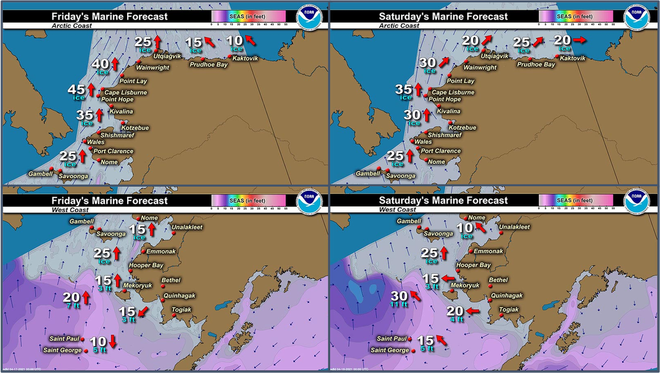
Marine forecast for the West Coast and Arctic Coast
Remote Sensing Images


Observations and Comments
Observations of Sea Ice Development
Observations from Diomede
12 April 2021 – Marty Eeleengayouq Ozenna
Hello from Inaliq. Would like to send pictures but we're having ground storm also snow and white out conditions, and out south side reopened also the north side been opening and closing but it's closed rite now. Only the south side is opened.
Update from later in the afternoon: The south side of the ice edge is open also its been open closing most of the winter. Also the north side has a open crack further out, also the weather just cleared up and possible the ice will come back in from the south as the wind change and repile.


15 April 2021 - Update
Thursday update from the south edge:


Observations from Port Clarence and Brevig Mission
15 April 2021 – Marcus Barr
With low ceiling and fog some areas it was hard to make an accurate ice report. I made it about 3 miles North of Cape Douglas where I last observed the ice last week.
Yesterday myself and a few other locals saw a couple bears while caribou hunting. Snow is getting soft and more tundra is starting to show.

Observations from Nome
16 April 2021 – Boogles Johnson
The sea ice has been static for the past week or has not open and closed back up. The attached picture is taken from the 3rd floor of the old federal building on front street in downtown Nome and currently there’s ice as far as you can see with the naked eye. We have had some serious snowfall this spring with the cold temps of -18 until the beginning of this week and has jumped to the 20-34 starting the spring thaw. I do not anticipate being able to hunt for another couple of weeks but only time will tell if the ice stays or goes.

Observations from Gambell
16 April 2021 – Clarence Irrigoo, Jr.
Couple days ago before the wind change boats that went out got walrus. Today the wind is from SW the ice from the south is coming in.

Additional Comments Provided by Local Experts and Other Contributors
Shared by Rick Thoman, ACCAP
15 April 2021
Some areas of low clouds persisting south of Bering Strait but generally clear enough for a good Thursday afternoon view of ice sea. Open water is evident beyond the shorefast ice in eastern Norton Sound and west of Nome, and if you look close, a small area north of Diomede. With mild weather and more south winds coming, look for dynamic sea conditions in the coming days in areas without shorefast ice.
