
Assessment of Current Ice Conditions Relevant to Distribution and Access of Walrus
Click the name of each community below to view more frequently updated and detailed information from the National Weather Service.
Synopsis – High pressure will quickly move east across the Bering Sea through Thursday night, then a low will move into the western Bering Sea Friday. That low will slowly move eastward across the central Bering Sea through Monday.
Near St. Lawrence Island
There is shorefast ice on the north, east, and south sides of St. Lawrence Island. On the north/south sides, generally extending 1 to 2 miles offshore, and on the east side, extending 2 to 5 miles offshore. Beyond the shorefast ice on the north and east sides of the island is very close pack ice to consolidated ice consisting of medium to vast floes.
There is a polynya south of the island that extends up to 3 miles from the southern coast, though it is re-freezing quickly. Beyond that polynya is new and young sea ice that has recently formed, and that extends 30 to 40 miles from the southern coast.
Nome
Shorefast ice around the Nome area extends up to 2 miles offshore from Sinuk to east of Solomon, and up to 7 miles offshore near Cape Rodney out to Sledge Island. Beyond the shorefast ice is a polynya that extends up to 8 miles, and is expanding. The main pack beyond the polynya is very close pack ice consisting of medium to vast floes.
Brevig Mission/Port Clarence Area
Shorefast ice extends 20 to 30 miles west/southwest of Brevig Mission. There is a polynya that extends up to 10 miles beyond the shorefast ice and is expanding. The main pack ice is very close pack ice consisting of medium to giant floes.
Wales to Shishmaref
Shorefast ice extends up to 2.5 miles from the coast. Beyond the shorefast ice is consolidated ice consisting of medium to giant floes.
Diomede
Shorefast ice persists between the islands. There is a small polynya that extends up to 1 mile south of the shorefast ice, then very close pack ice consisting of big to giant floes extends well beyond that as well as north of the island. To the east of the island is close pack ice consisting of big to giant floes.
Forecast Discussion
Ice Forecast
Sea ice will move westward Friday, April 9th and Saturday, April 10th, up to 20 miles then drift southwestward through Tuesday the 13th. Sea ice will likely move back to the north Wednesday, April 14th through Friday, April 16th.


Wind Synopsis
Friday, April 9th east wind 15 to 25 kts (17 to 29 mph) increasing to northeast 20 to 30 kts (23 to 35 mph) by Sunday, April 11th during the early morning. The wind shifts to the northwest and diminishes to 10 to 20 kts (12 to 23 mph) by Tuesday, April 13th's early morning hours. Tuesday, April 13th's evening the wind becomes southerly at 5 to 10 kts ( 8 to 12mph). Late Wednesday, April 14th into early Thursday, April 15th the wind shifts to the southeast and then to the northeast during the period slowly and increases to 10 to 20 kts (12 to 23 mph). Friday, April 16th the wind shifts into the northwest at 10 to 20 kts (12 to 23 mph).
Temperature Trend
Friday, April 9th maximum temperatures will range from 5 below to 5 above zero trending up to zero to 15 above on Saturday, April 10th with the highest readings in Norton Sound. The maximum temperatures continue to trend upward to 15 to 25 degrees by Monday, April 12th. The Maximum temperatures will increase into the 20s on Tuesday, April 13th and remain in the 20s through Friday, April 16th.
Friday, April 9th minimum temperatures will range from 10 to 20 below zero then trending up to 5 to 15 above zero by Monday, April 12th. Minimum temperatures will remain in the teens through Friday, April 16th.
Daily Weather, Wind, and Temperature Updates
The National Weather Service provides twice-daily, text only updates on the weather, wind, and temperature conditions in specific geographical zones. An interactive weather map for access to other Alaskan zones can be found here: http://weather.gov/anchorage/ice
Higher resolution satellite images and wind maps (wind updated daily) can be viewed here: http://www.weather.gov/afg/SIWO_overview
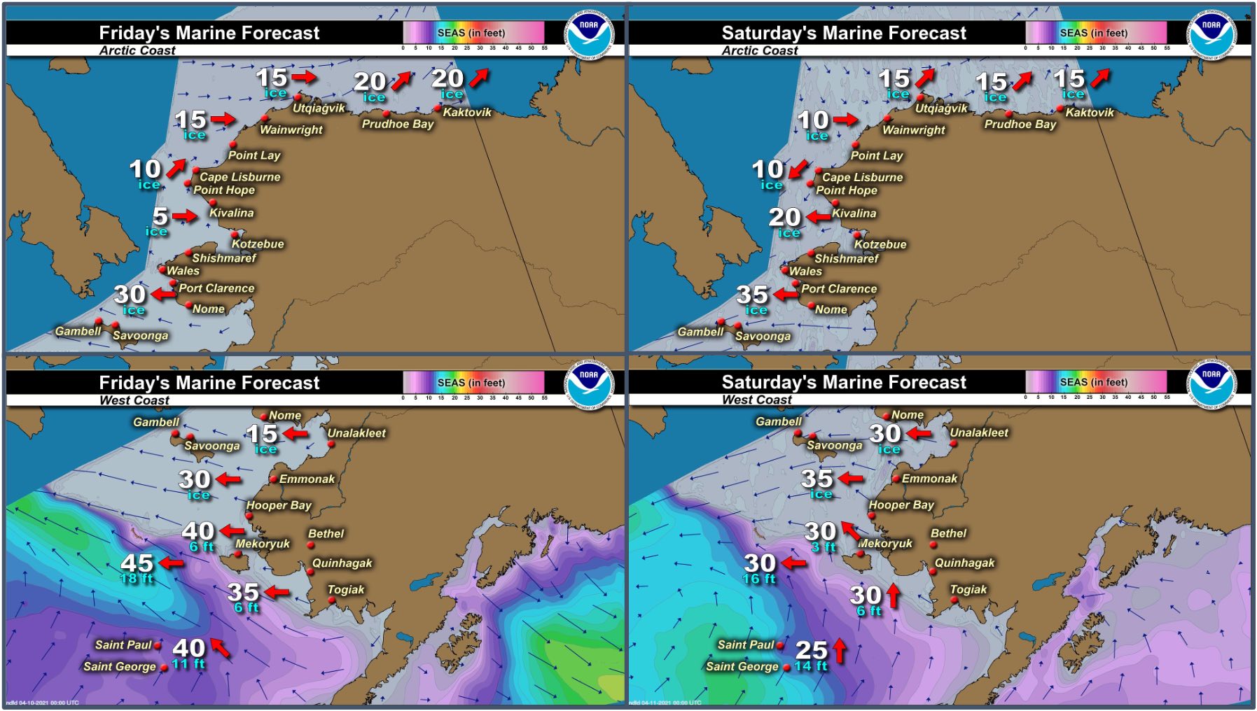
Marine forecast for the West Coast and Arctic Coast
Remote Sensing Images


Observations and Comments
Observations of Sea Ice Development
Observations from Savoonga
8 April 2021 – Aqef Waghiyi
No open water. Just a few open leads here and there north of town. Couple days ago people seen a couple walrus and seals a few miles down. Wind keeps changing and didn’t go to south side yet.
Observations from Port Clarence and Brevig Mission
8 April 2021 – Marcus Barr
Went to Cape Douglas, 25 miles South of Brevig. Rough shorefast ice, ice fog about 4-5 miles out where the open water is, some open spots but very small and not many. 10 miles West of Douglas is a little bit more flat ice and the ice edge is little further out. Snow birds are seen in town, weather will be warming up next week.


Observations from Gambell
9 April 2021 – Clarence Irrigoo, Jr.
Ice is moving every day, one day lots of water and next day ice came back. Walrus on ice way out.
