
Assessment of Current Ice Conditions Relevant to Distribution and Access of Walrus
Click the name of each community below to view more frequently updated and detailed information from the National Weather Service.
Synopsis Several weak fronts will affect the Bering Sea, one in the eastern Bering Sea, one in the western Bering Sea. A strong front will traverse the Bering Sea from west to east Monday and Tuesday. The next strong low/front will come into the central Bering Sea on Saturday. The latter will be associated with a low-pressure system moving from west to east around 62N. The next strong front and low pressure moves into the Bering Sea on Sunday.
Near St. Lawrence Island
There is shorefast ice on the north, east, and south sides of St. Lawrence Island, extending 2 to 4 miles offshore. There is a polynya extending up to 8 miles offshore between Iwoorigan Camp and just west of Savoonga, and another polynya extending 3 to 11 miles offshore from Ataakas Camp to Camp Kulowiye. Beyond these polynyas is very close pack ice consisting of small to vast floes.
Nome
This area has not yet begun for the 2021 season.
Brevig Mission/Port Clarence Area
Shorefast ice extends 20 miles west of Brevig Mission, then the main ice pack consisting of medium to giant floes lies beyond that.
Wales to Shishmaref
This area has not yet begun for the 2021 season.
Diomede
This area has not yet begun for the 2021 season.
Forecast Discussion
Ice Forecast
Sea ice will generally move southward Friday, March 26 and Saturday, March 27th, then westward Sunday, March 28th and Monday, March 29th. The ice pack will likely drift southward to southeastward Tuesday, March 30th through Thursday, April 1st.


Wind Synopsis
Northeast winds 15 to 20 kt (17 to 23 mph) on Friday, March 26th will become variable 10 kt (11 mph) by Saturday, March 27th. Winds will shift to the east Sunday, March 28th and increase to 30 to 40 kt (35 to 46 mph). On Monday, March 29th, winds will become northerly 25 to 30 kt (29 to 35 mph) but then gradually diminish to 15 to 20 kt (17 to 23 mph) by Wednesday, March 31st and persist through Friday, April 2nd.
Temperature Trend
High temperatures Friday, March 26th and Saturday, March 27th will range from zero to 10 above with overnight lows from zero to 10 below. Temperatures will warm slightly Sunday, March 28th through Monday, March 29th with highs in the teens to lower 20s and overnight lows from zero to 10 above. Temperatures will then cool back down by Tuesday, March 20th with highs zero to 10 above and lows zero to 10 below persisting through Friday, April 2nd. The warmest temperatures for the upcoming week will be over St. Lawrence Island.
Daily Weather, Wind, and Temperature Updates
The National Weather Service provides twice-daily, text only updates on the weather, wind, and temperature conditions in specific geographical zones. An interactive weather map for access to other Alaskan zones can be found here: http://weather.gov/anchorage/ice
Higher resolution satellite images and wind maps (wind updated daily) can be viewed here: http://www.weather.gov/afg/SIWO_overview
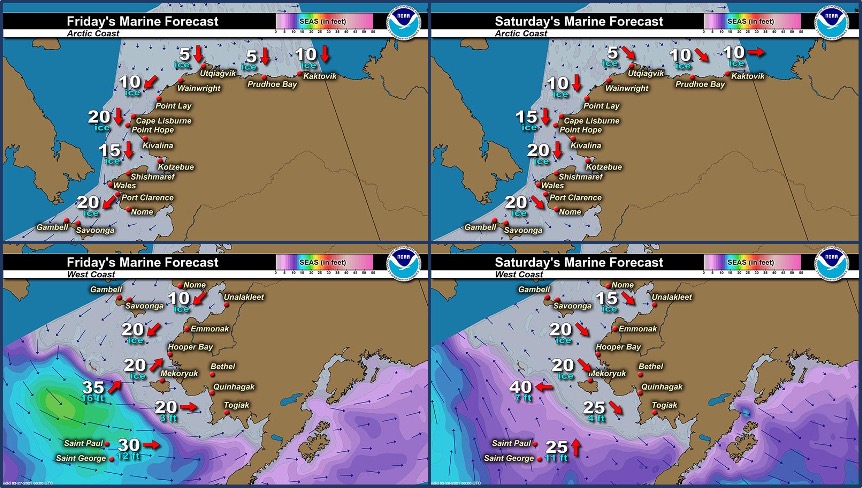
Marine forecast for the West Coast and Arctic Coast
Remote Sensing Images


Observations and Comments
Observations of Sea Ice Development
Observations from Shishmaref
25 March 2021 – Curtis Nayokpuk
Sea ice out front has frozen solid and southerly winds have not moved ice out as in past few years. Some leads showed up along shore fast ice couple days ago about three miles out when east winds gust to 40-50.
Observations from Port Clarence and Brevig Mission
25 March 2021 – Marcus Barr
Still iced in and not hunting yet.
Observations from Savoonga
25 March 2021 – Aqef Waghiyi
There is open water but maybe not enough. When the wind died down the ice came back up a little bit. There’s patches of open water here and there. Don’t think nobody went boating today. Might take a week for Savoonga. Getting ready to go to south side.
Additional Comments Provided by Local Experts and Other Contributors
Shared by Rick Thoman, Alaska Center for Climate Assessment and Policy (ACCAP)
25 March 2021

