
Assessment of Current Ice Conditions Relevant to Distribution and Access of Walrus
Click the name of each community below to view more frequently updated and detailed information from the National Weather Service.
Synopsis A broad low pressure over the southern Bering will dissipate while a stronger northwest Pacific low pressure will weaken in place through Monday.
Near St. Lawrence Island
Satellite imagery from the evening of Wednesday, May 20th and morning of Thursday, May 21st shows the shorefast ice on the north side of the island remains intact especially from Savoonga eastward, extending up to 7 miles offshore. From Gambell to Kangee Camp, shorefast ice extends from about 1 miles to 3 miles offshore. Between Kangee Camp and Savoonga, there is an area of very close pack ice with medium to vast floes with a bit of open water just west of Savoonga. South of the island is ice free and west of the island is open water. Savoonga east to approximately 10 miles east of Camp Kulowiye and north to the Bering Strait is generally very close pack ice consisting of big to giant floes.
Nome
Shorefast ice is rapidly deteriorating in this area. From Nome to Port Safety there is very open pack ice with small floes that extends up to 3 miles offshore. Some shorefast ice remains around Port Safety, extending one-half mile offshore. Open water extends from Solomon to Port Safety up to 4 miles offshore. Otherwise the surrounding area is close pack ice consisting of big to vast floes.
Brevig Mission/Port Clarence Area
Shorefast ice extends approximately 35 miles to the west of Brevig Mission. Beyond the shorefast ice is open water.
Wales to Shishmaref
Ice around Wales remains shorefast 1 to 3 miles offshore. Near Mugisitokiwik to Ikpek there is consolidated pack ice with medium to vast floes anywhere from 15 to 30 miles offshore. About 15 miles offshore Shishmaref, there is an area of open pack ice to the northwest. Otherwise, compact pack ice consisting of big to giant floes covers the rest of the surrounding area.
Diomede
Sea ice remains shorefast between Little Diomede and Big Diomede Island. There is very close pack ice to the east and north of both islands with medium to vast floes. To the south and west, an area of very open pack ice exists with small to medium floes.
Forecast Discussion
Ice Forecast
Sea ice will generally continue to drift southward to southwestward through Thursday the 28th. During times of light and variable winds, sea ice will generally move by local currents. Existing polynyas will continue to expand southwestward as well through the next week.


Wind Synopsis
Northeast winds 10 to 15 kt (11 to 17 mph) on Friday, May 22nd will increase to 20 to 25 kt (23 to 29 mph) on Saturday, May 23rd from St. Lawrence Island through the Bering Strait. The strong winds from St. Lawrence Island to the Bering Strait will diminish on Monday, May 25th, with winds becoming variable 5 to 10 kt (5 to 11 mph) across the region on Monday. Winds will shift to the southeast 10 to 15 kt (11 to 17 mph) Tuesday, May 26th with little change through Wednesday, May 27th. Winds will become variable 5 to 10 kt (5 to 11 mph) on Thursday, May 28th and persist into Friday, May 29th.
Temperature Trend
High temperatures from Friday, May 22nd through Friday, May 29th will be in the mid 30's to near 40 degrees across St. Lawrence Island and from the Bering Strait northward. Daytime temperatures ranging from the mid 40's to lower 50's are expected along the southern Seward Peninsula from Teller to Nome. Overnight low temperatures will be in the lower 30's from St. Lawrence Island and from Bering Strait northward, but in the upper 30's to lower 40's along the southern Seward Peninsula.
Daily Weather, Wind, and Temperature Updates
The National Weather Service provides twice-daily, text only updates on the weather, wind, and temperature conditions in specific geographical zones. An interactive weather map for access to other Alaskan zones can be found here: http://weather.gov/anchorage/ice
Higher resolution satellite images and wind maps (wind updated daily) can be viewed here: http://www.weather.gov/afg/SIWO_overview
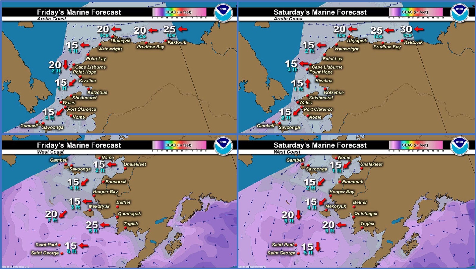
Marine forecast for the West Coast and Arctic Coast
Remote Sensing Images


Observations and Comments
Observations of Sea Ice Development
Observations from Gambell
21 May 2020 – Clarence Irrigoo, Jr.
Nobody this week went boating, we're having high wind from the northeast. The ice from other side is coming out and getting smaller.
Observations from Diomede
22 May 2020 – Marty Eeleengayouq Ozenna
South side opened up a lot and the north side pushing south, and the middle finally broke before I went up took this picture, also next nice weather boats be in the water.


Observations from Shishmaref
22 May 2020 – Curtis Nayokpuk
Thick fog again this AM. Thin ice rotting fast with rain last couple days. No Ice map for northern Seward Peninsula but see one (Polar View 5/21/2020) for Norton Bay.


Observations from Port Clarence and Brevig Mission
22 May 2020 – Marcus Barr
Still lots of shorefast ice, it’s getting thin though and the cracks are really wide now.
Photos coming soon!
Observations from Savoonga
22 May 2020 – Aqef Waghiyi
Nobody went boating since last week. Not much open water, lots of shore ice packed in. Thick fog too. Windy, north at 12mph.
Observations from Wales
22 May 2020 – Robert Tokeinna, Jr.
These past two weeks have been cool and breezy with ice fog now and again. Lots of birds and ducks passing. I am unsure if any boats have gone out hunting, but it's been cool and breezy for the most part of the 14 days. Ice has been steady and seems to be anchored well, but other neighboring villages have reported of ice moving and cracks getting wider. I have no photos and should be getting one soon. It will depend if this ice fog lightens and lifts. Mostly northerly winds and temperatures in between 20s and 30s in Wales these past few weeks. No change to that in the near future, but remain optimistic for warmer sunshiney weather soon. We are still closed due to COVID-19. Neighboring community hunters are encouraged to bring enough gas and food for your travels as Wales is still in the hunkering down and social distancing. Two weeks we will be looking at our travel options for the community of Wales.
Additional Comments Provided by Local Experts and Other Contributors
Shared by Rick Thoman, ACCAP
19 May 2020
The past several days there have been issues with the satellite images being posted to the UAF/GINA website, but one did appear late Monday afternoon. It's quite far west and cuts off eastern Norton Sound, but there are enough clear skies to see some of the ice details in this false color image: ice and snow is the turquoise blue, almost black is water, white is cloud, brown is snow-free land. Still a little fast ice hanging on east of Cape Darby, but the ice in western Norton Sound south of Nome looking pretty broken. A lot of open water now on the west side of the Bering Strait and lots of water around Diomede now. There is still ice west and southwest of Gambell, which can be seen in places through the clouds. Ice pretty much packed up on the northern Seward Peninsula coast but it does not look like much, if any, is fast ice.
