
Assessment of Current Ice Conditions Relevant to Distribution and Access of Walrus
Click the name of each community below to view more frequently updated and detailed information from the National Weather Service.
Synopsis High pressure will remain over the eastern Beaufort Sea through Monday. Low pressure over the southwest Bering Sea will gradually weaken, then another low will move into the same area Friday through Monday.
Near St. Lawrence Island
Satellite imagery from the evening of 6 May shows the shorefast ice on the north side of the island remains intact. From Gambell to Kangee Camp it extends from about 1 miles to 4 miles off-shore. Between Kangee Camp and Savoonga there is an area of compact pack ice with medium to vast floes. Shorefast ice continues from just west of Savoonga past Camp Kulowiye, extending southward across the eastern edge of the island and extends roughly 1 to 3 miles away from the coast except for offshore Camp Iveetok where it extends 6–7 miles offshore. There is also shorefast ice on the south side of the island, extending 2–3 miles from shore from Powooiliak Camp and east to just past Silook Camp. South and west of the island are areas of open water. The open water extends up to 20 miles west and up to 65 miles south of Booshu Camp. Open water also extends up to 20 miles south of Siknik Training Camp, with an area of small ice cakes to medium floes south of Silook Camp. Beyond these areas, consolidated to compact pack ice consisting of big to giant floes surrounds St. Lawrence Island.
Nome
Shorefast ice offshore Nome extends up to 2 miles offshore east to Tonok and west to beyond Sinuk. Past the shorefast ice there are pockets of very open pack ice, otherwise the surrounding area is very close pack ice.
Brevig Mission/Port Clarence Area
Shorefast ice extends approximately 35 miles to the west of Brevig Mission. Away from the shorefast ice, open water has developed to roughly 25 miles to the west. Otherwise consolidated pack ice surrounds the area with big to vast floes.
Wales to Shishmaref
Ice around Wales remains shorefast 1 to 3 miles offshore, then open water extends up to 14 miles west and continues southward toward northwest Norton Sound. There is an area of close pack ice approximately 30 miles north of Wales. From Mugisitokiwik to Ikpek, it is hard to tell if the ice is fast, but it remains compact pack ice with big to vast floes. This compact ice extends 12 to 20 miles offshore. Shorefast ice remains from 2.5 miles northeast of Ikpek along the coast to Kividlo roughly 2-4 miles away from the coast. From Kividlo to Espengberg shorefast ice rapidly extends away from the coast into Kotzebue Sound. Otherwise, compact pack ice consisting of big to giant floes covers the rest of the surrounding area.
Little Diomede
Sea ice is shorefast between Little Diomede and Big Diomede Island. There is a small area just north of Diomede that is approximately 2 miles by 3 miles of very open pack ice. There is a polynya that extends from approximately 7 miles east of Diomede to the shorefast ice near Wales, with open water. Otherwise, consolidated ice consisting of vast to giant floes surrounds Diomede.
Forecast Discussion
Ice Forecast
Sea ice will generally continue to move west to southwest through Wednesday, May 13th. Polynyas will continue to form and expand off south and west-facing coastlines as well. Shorefast ice on south and west-facing coastlines may break off especially during periods of stronger winds. Sea ice will continue to be compact against north-facing coastlines through Wednesday, May 13th.

Wind Synopsis
Expect east winds 10 to 15 kt (11 to 17 mph) on Friday, May 8th. Winds will shift to the southeast Saturday, May 9th and increase to 25 to 30 kt (29 to 35 mph) across St. Lawrence Island, but remain southeast 10 to 15 kt (11 to 17 mph) elsewhere. On Sunday, May 10th, southeast winds will diminish to 10 to 15 kt (11 to 17 mph) across St. Lawrence Island. From Monday, May 11th through Wednesday, May 13th, expect variable winds 5 to 10 kt (5 to 11 mph). On Thursday, May 14th, winds will become northerly 10 to 15 kt (11 to 17 mph) and persist through Friday, May 15th.
Temperature Trend
High temperatures from Friday, May 8th through Friday, May 15th will range from the 30's around St. Lawrence Island, around 40 from the Bering Strait northward, and in the upper 40's to lower 50's along the southern Seward Peninsula. Low temperatures are expected to be around 30 from St. Lawrence Island and north of the Bering Strait, and in the upper 30's along the southern Seward Peninsula.
Daily Weather, Wind, and Temperature Updates
The National Weather Service provides twice-daily, text only updates on the weather, wind, and temperature conditions in specific geographical zones. An interactive weather map for access to other Alaskan zones can be found here: http://weather.gov/anchorage/ice
Higher resolution satellite images and wind maps (wind updated daily) can be viewed here: http://www.weather.gov/afg/SIWO_overview
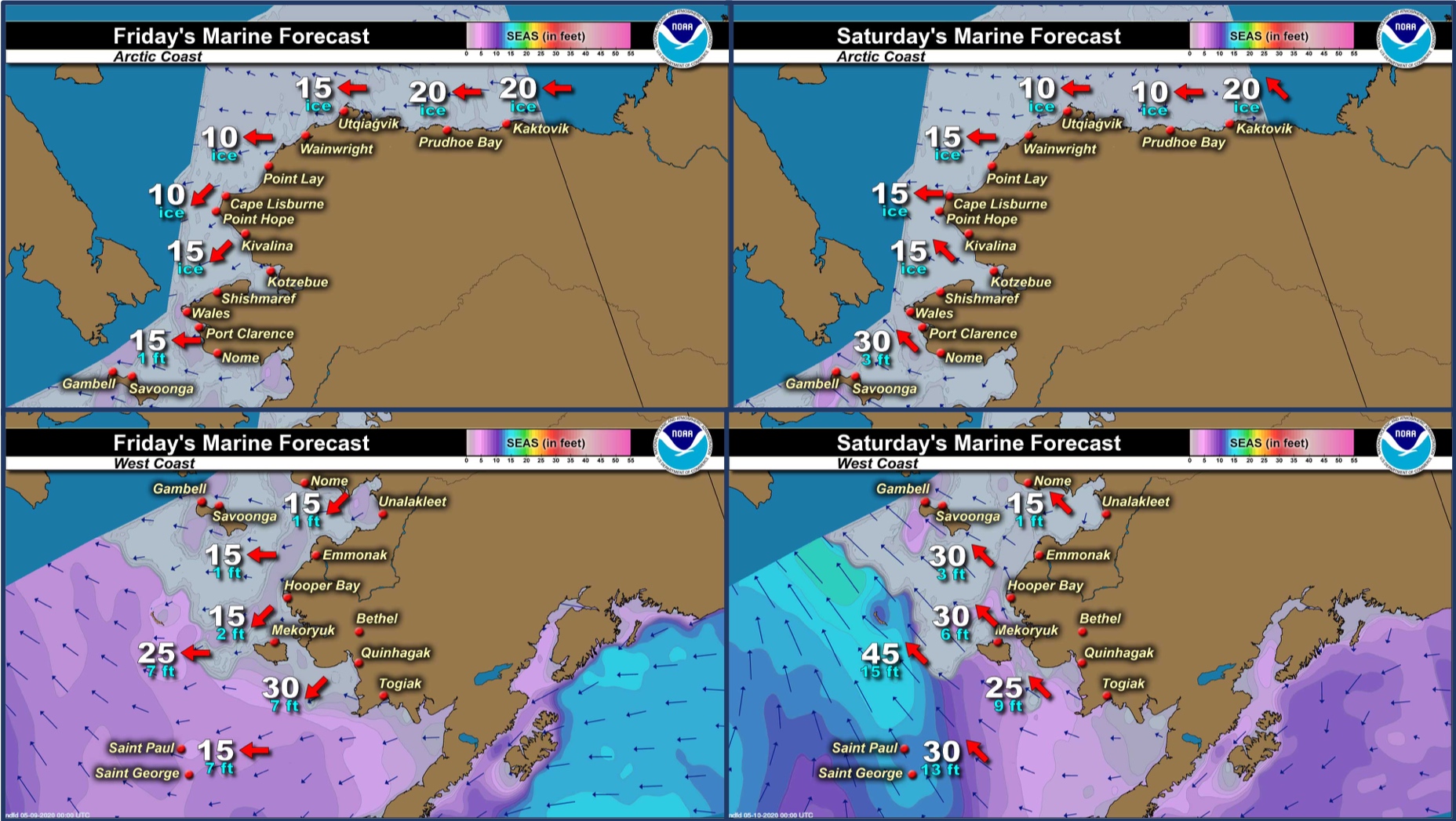
Marine forecast for the West Coast and Arctic Coast
Remote Sensing Images


Observations and Comments
Observations of Sea Ice Development
Observations from Wales
7 May 2020 – Robert Tokeinna, Jr.
This week started out with ice fog in the mornings while it burned off in the evenings, but some days it stuck around. Very mild week in Wales ranging in the single digits and high as upper 20s. As for the wind, it stayed easterly from northeast, southeastly, and just east wind. It ranged from a light breeze to gusting 30 mph. I seen some cranes and more sea gulls this week. It supposed to be warmer and a bit sunnier this weekend, but it's also spring, so expect some ice fog to linger if any around. I have seen more activity on the ice as most boats have been brought to the local launch site which is located below the 4-plex teacher housing. Great day for pictures, so here they are from Cape Prince of Wales Mountain. Good luck to all boats and stay safe.


 - view 3.")


Observations from Gambell
8 May 2020 – Clarence Irrigoo, Jr.
Went out twice this week, games start to show up in the ice, some hunters are getting walrus and bearded seals.


Observations from Shishmaref
8 May 2020 – Curtis Nayokpuk
Nothing new, hunters getting boats ready. Morning fog lately.
UPDATE - 10 May 2020 – Curtis Nayokpuk
Lots of little birds and ducks show up last couple days. Thin sea ice snow cover melting and leads open up with south/SE winds. Most hunters out hunting ducks before trails and rivers flood out.

Observations from Savoonga
8 May 2020 – Aqef Waghiyi
Just back last night from south side. We got to the ice and the walrus were further in the bunched up ice. Couldn’t get to them. Weather has been pretty good.
Observations from Port Clarence and Brevig Mission
8 May 2020 – Marcus Barr
Sea ice conditions from seal camp 10 miles west of Brevig. Snow is melting on top of the ice and cracks on the beach are getting wide. There is an open spot in our lagoon. Locals are getting geese now. No open ocean yet to be seen.


Observations from Nome
8 May 2020 – Boogles Johnson
The hunting is in full swing in the Nome area. The ice conditions are excellent for all the sea life. Our crew got stuck in the ice on two trips this week. We spent 2 nights on the ice. The ice is ready for when the walrus arrive. We didn’t see any walrus this week.


Observations from Diomede
8 May 2020 – Marty Eeleengayouq Ozenna
North side still opening and closing and still holding. South side just staying closed and open every now and then, but staying closed and still glued in-between the islands still and people still hand line crabbing.


UPDATE - 10 May 2020 – Marty Eeleengayouq Ozenna
South side of the island still stuck but today is our third day melting with the heat waves and the north side is opening up but looking like our ice is melting off not breaking, also the island is losing the snow cover.


Additional Comments Provided by Local Experts and Other Contributors
Shared by Rick Thoman, ACCAP
Another great view of the region Thursday afternoon. Areas of snow-free ground on the Seward Peninsula are increasing. Except for the rotting ice in Norton and Golovin Bays there's getting to be only a very narrow area of shorefast ice on the coast east of Sledge Island. All that open water in eastern Norton Sound is soaking in the sunshine. Still clogged with jumbled ice from Little Diomede to southeast of St. Lawrence Island, but open water persisting from north of Wales to southeast of King Island.
