
Assessment of Current Ice Conditions Relevant to Distribution and Access of Walrus
Click the name of each community below to view more frequently updated and detailed information from the National Weather Service.
Synopsis A weak low in the southwest Bering Sea will dissipate as another larger and stronger low moves into the southern Bering Sea Thursday and gradually weakens through Monday.
Near St. Lawrence Island
Satellite imagery shows that shorefast ice remains intact on the north side of the island, extending 1 to 6 miles from the coast. There is also shorefast ice on the south side of the island, extending up to 6 miles from shore. A couple polynyas have formed north of the shorefast ice from near Iwoorigan Camp to north of Kangee Camp, as well as from north of Camp Iveetok to near Camp Kulowiye. Both polynyas extend up to 9 miles from the shorefast ice. Otherwise, consolidated to compact pack ice consisting of big to giant floes surrounds St. Lawrence Island.
Nome
Sea ice is shorefast from 1 to 6 miles from just east of Solomon to Sinuk, then consolidated to compact pack ice covers the rest of the surrounding area.
Brevig Mission/Port Clarence Area
Shorefast ice extends approximately 17 miles to the west of Brevig Mission, with compact pack ice covering the rest of the surrounding area.
Wales to Shishmaref
The shorefast ice extent along the coast varies from a half mile from Mugisitokiwik to Ikpek, then 2 to 4 miles from Ikpek to Espenberg. There is a polynya between Mugisitokiwik and Ikpek that extends up to 5 miles from the shorefast ice, and another narrower polynya from east of Shishmaref to Espenberg then north to near Tikizat. Otherwise, consolidated pack consisting of big to giant floes covers the rest of the surrounding area, with shorefast ice covering Kotzebue Sound.
Little Diomede
Sea ice is shorefast between Little Diomede and Big Diomede Island. There is a small polynya to the north of Diomede, stretching up to 1 mile from the shorefast ice. Otherwise, consolidated ice consisting of vast to giant floes surrounds Diomede.
Forecast Discussion
Ice Forecast
For Norton Sound region:
Sea ice will generally continue to move northward and condense against south-facing coastlines through Friday the 24th. Polynyas will continue to form and expand off north-facing coastlines as well. Shorefast ice on north-facing coastlines may break off especially during periods of stronger winds.
For St. Lawrence Island and Bering Strait region:
As the winds become northeasterly, sea ice will drift southwestward. Polynyas that have formed of north-facing coastlines will fill in and new polynyas will likely form off south-facing coastlines.

Wind Synopsis
Wind Synopsis for Norton Sound region:
Friday the 17th, southeast wind 7–10 knots (10–15 mph) shifting to the south-southwest 8–13 knots (10–15 mph) Friday night through Saturday the 18th. Sunday night on the 19th wind shifting from south-southeast 8-13 knots (10–15 mph) to the northeast 4–8 Knots (5–10 mph) early Monday morning the 20th. The wind increasing from the northeast on Wednesday the 22nd to 10–14 knots (12–17 mph) through Friday the 24th.
Wind Synopsis for St. Lawrence Island and Bering Strait region:
Friday the 17th southeast wind 5–9 knots (7-12 mph) will shift northeast Saturday the 18th in the afternoon and increase to 10–14 knots (12–17 mph) Saturday the 18th overnight. Monday the 20th the wind will shift to the north at 8–12 knots (10–15 mph) and last until Wednesday night the 22nd when it increases to 12–17 knots (15–20 mph) then shifts on Thursday the 23rd to the northeast at 8-12 knots (10–15 mph) through Friday the 24th.
Temperature Trend
On Friday the 17th high temperatures will range from the upper 30s in Norton Sound to low 30s in the Bering Strait. A cool trend starts on Saturday the 18th with maximum temperatures in the mid-30s for Norton Sound to the upper 20s to near 30 for the Bering Strait and St. Lawrence Island. Minimum temperatures on Saturday the 18th will range from the mid-20s in Norton Sound to teens for St. Lawrence Island and the Bering Strait. Sunday the 19th through Thursday the 23rd maximum temperatures will range in the mid to upper 20s for Norton Sound and the upper teens to lower 20s for St. Lawrence Island and the Bering Strait region. Friday the 24th will feature a warming trend with highs in the mid-30s for Norton Sound and upper 20s for St. Lawrence Island and the Bering Strait region.
Daily Weather, Wind, and Temperature Updates
The National Weather Service provides twice-daily, text only updates on the weather, wind, and temperature conditions in specific geographical zones. An interactive weather map for access to other Alaskan zones can be found here: http://weather.gov/anchorage/ice
Higher resolution satellite images and wind maps (wind updated daily) can be viewed here: http://www.weather.gov/afg/SIWO_overview
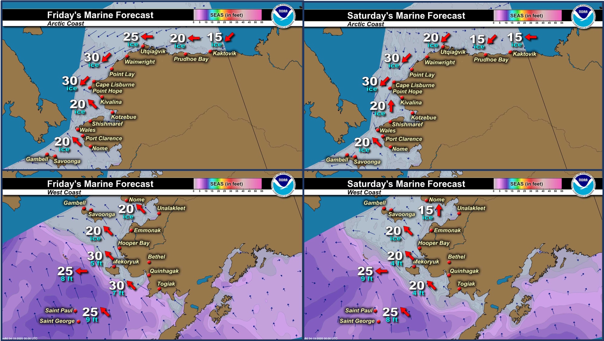
Marine forecast for the West Coast and Arctic Coast
Remote Sensing Images


Observations and Comments
Observations of Sea Ice Development
Observations from Port Clarence and Brevig Mission
16 April 2020 – Marcus Barr
It's been warm this past week averaging 35°F. The snow is soft and slushy now from the warm southerly winds. Seagulls was spotted here in Brevig. As for the ice report, there are more and more seals coming up on the ice, some hunters went near Port Clarence, including myself, to hunt bearded seal on the ice but no luck yet. Still no sign of open water and some cracks are starting to show along the beach ice.

Observations from Gambell
16 April 2020 – Clarence Irrigoo, Jr.
Yesterday we went out but heavy dense fog only see some seals, boats are going out now kinda windy.


16 April 2020 – Gugugyi Apasengaq
Opening up fast – SE winds.

Observations from Nome
16 April 2019 – Boogles Johnson
Good afternoon, we still have shorefast ice in Nome, the hunters are gearing up in anticipation of the ice going anytime now since it has been above freezing. The word around St. Michael/Stebbins is that after the high winds last week they have open water and are starting their spring hunting. Nome has the first Covid-19 victim as of yesterday. I've been hunkered down for some time with my family only heading to town when we need groceries or pay bills.
Observations from Wales
17 April 2020 – Robert Tokeinna, Jr.
It has been a warm week along with clouds, ice fog, wind, snow, and more recently rain. I wanted to get a picture, but ice fog and white out conditions lately. I seen a bunch of snowbirds and sounds of sea gulls around town. Wind varied between near calm to gusty south winds, switching north, east, west, and any combination of everything possible to 40 mph or more. Temperatures have been between 15 to warm as upper 30s. I have noticed a local fishing on ice is my guess, but due to social distancing I elected not to go check if they caught anything. Pools of water on the ice and around town are noticeable. With snow and rainfall in the forecast, we will continue to see further thawing around town. As for the ice conditions, I have noticed open water to the north and south meaning the ice is free flowing in the current. The seashore fast ice is still intact and hope it sticks around a bit longer.
Pictures to follow once opportunity arises.
Observations from Shishmaref
16 April 2020 – Curtis Nayokpuk
Raining here, might see some sun by afternoon?
17 April 2020 – Curtis Nayokpuk
Raining again today, hunters digging out boats. A lot of thin ice and
open leads can be seen.


Observations from Savoonga
17 April 2020 – Aqef Waghiyi
Foggy past couple days now. Snow mixed with rain. Snow’s melting pretty fast out there. Not windy, just wet weather past couple days. Yesterday one boat went out but I don’t know what they got. Lots of open water. Too foggy today to see anything so no photos.