
Assessment of Current Ice Conditions Relevant to Distribution and Access of Walrus
Click the name of each community below to view more frequently updated and detailed information from the National Weather Service.
Forecast Synopsis for 18 – 22 April 2019
Synopsis. High pressure will generally persist across the Arctic as well as the southwest Bering Sea, while low pressure remains over the Alaska mainland through Monday.
Near St. Lawrence Island
Northerly winds have continued to bring the main area of consolidated pack ice consisting of big to giant floes toward the coast. From Gambell south, some additional sea ice has drifted southward as much as 87 nm south of Gambell. Similarly, from Camp Kulowiye, some thicker sea ice has drifted southward up to 54 nm. New sea ice has formed south of the island up to 55 nm from shore with ice cakes and small floes. To the west of Gambell, the consolidated pack ice extends up to 2 nm from shore, then close pack ice consisting of ice up to 12 inches thick extends to the Russian coast. There is an area of thicker consolidated pack ice to the northeast approximately 25nm from Gambell.
Nome
An area of new sea ice has begun to form to the southwest of Nome. South and east of Nome, there is close pack ice with new sea ice forming quickly up to 60nm south of Nome and along the coast to the east. Southeast of Nome, there is some very close pack ice with medium to big floes extending from 10 to 20 nm southeast of Nome. Otherwise, new sea ice is quickly growing to the east and southeast as northerly winds persist.
Brevig Mission/Port Clarence Area
Generally, shorefast ice exists from Brevig Mission to Port Clarence. New sea ice is quickly filling in between the coast and the thicker pack ice that is approximately 25 nm west of Port Clarence.
Wales to Shishmaref
Consolidated pack ice consisting of big to giant floes extends 60 nm north of the Wales to Shishmaref coastline. Close pack ice exists beyond that to the Cape Krusenstern to Point Hope coastline as a polynya forms and new sea ice quickly forms where there is open water.
Little Diomede
A polynya has formed to the south of Diomede up to 8 nm, and is filling in with new sea ice. Otherwise, very close pack ice extends to the Wales coast, well into the Chukchi Sea, south to St. Lawrence Island, and 18 nm west of Diomede.
Forecast Discussion
Ice Forecast
Sea ice will generally drift 30 to 50 nm south over the next week. New sea ice growth is expected to continue in areas of open water through at least next Tuesday.

Wind Synopsis
On St. Lawrence Island, northeast winds 5 to 10 kt (6-11 mph) on Friday, April 19th will increase to 10 to 15 kt (11-17 mph) on Saturday, April 20th. Winds will become north at 15 to 20 kt (17-23 mph) on Sunday, April 21st and Monday, April 22nd. On Tuesday, April 23rd and Wednesday, April 24th, winds will become northwesterly at 10 to 15 kt (11-17 mph). On Thursday, April 25th and Friday, April 26th, winds will become northeast at 10 to 15 kt (11-17 mph).
At Nome, north winds 10 to 15 kt (11-17 mph) on Friday, April 19th and Saturday, April 20th. Winds will increase to 15 to 20 kt (17-23 mph) from the north on Sunday, April 21st through Tuesday, April 23rd. Winds will decrease on Wednesday, April 24th and Thursday, April 25th to northwest at 5 to 10 kt (6-11 mph). Winds will become northeast at 5 to 10 kt (6-11 mph) on Friday, April 26th.
Temperature Trend
High temperatures will generally be in the upper teens and lower 20's Friday, April 19th through Tuesday, April 23rd. At Nome, high temperatures will increase to the upper 20's and lower 30's Wednesday, April 24th through Friday, April 26th. On St. Lawrence Island, high temperatures will rise to the lower to middle 20's Wednesday, April 24th through Friday, April 26th.
Low temperatures will generally be in the lower teens Friday, April 19th through Tuesday, April 23rd. Low temperatures will rise into upper teens and lower 20's Wednesday, April 24th through Friday, April 26th.
Daily Weather, Wind, and Temperature Updates
The National Weather Service provides twice-daily, text only updates on the weather, wind, and temperature conditions in specific geographical zones. An interactive weather map for access to other Alaskan zones can be found here: http://weather.gov/anchorage/ice
Wind maps are updated daily and can be viewed here: http://www.weather.gov/afg/SIWO_overview
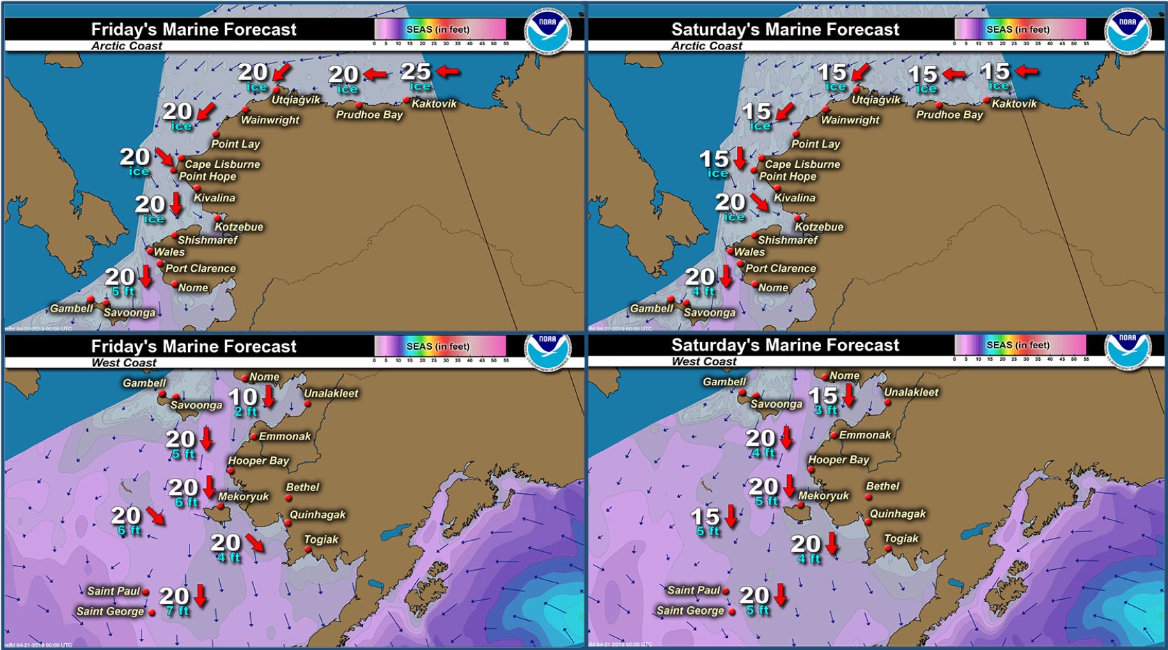
Marine forecast for the West Coast and Arctic Coast
Remote Sensing Images


Observations and Comments
Observations of Sea Ice Development
Observations from Wales
19 April 2019 – Robert Tokeinna, Jr.
This week has made some progress with more ice forming, thanks to a one good cold snap this past week with snowy and cold northerly winds dominated the week. Local boat crew was seen digging out boats. Ice seem to be regrouping around from our local lighthouse to our inlets. Still expecting a little bit more snow. This week we had lows in the single digits and highs in the lower to mid 20s with dominant north winds with the occasional east and south winds as low pressure passes Wales. Very humid with pretty much cloud cover and snow. Here ends my observation.
Observations from Nome
19 April 2019 – Boogles Johnson
There currently is pack ice south of Cape Nome which is good ice. We found Oogruk "bearded seal" and were successful and are now done Oogruk hunting for this season. The walrus have been to the west of Nome by Sledge Island making their migration north with their babies. The season is approx. 1 month early from previous years but the advantage is that we have snow for natural refrigeration and cold temps to preserve the catch. It has been a successful season for my crew I'm with this year and I hope all hunters are able to bring home catch to their families and community.


Observations from Savoonga
18 April 2019 – Aqef Waghiyi
No boating in forever. Barely snowing and can’t see too far. Too much ice for people to go out, no leads. Will try to get a photo later on.
Observations from Gambell
18 April 2019 – Clarence Irrigoo, Jr.
The whalers landed a 57-foot whale on the 13 April 19. Lots of ice still around and the weather is very windy.


UPDATE - 19 April 2019 – Clarence Irrigoo, Jr.
Herd of walrus showing up from the North.

Observations from Port Clarence and Brevig Mission
18 April 2019 – Marcus Barr
With strong northerly winds all week the shorefast ice continued to break off. Low temperature made little bit of slush. The ice edge from Brevig is now 5 miles west.

