
Assessment of Current Ice Conditions Relevant to Distribution and Access of Walrus
Click the name of each community below to view more frequently updated and detailed information from the National Weather Service.
Forecast Synopsis for 4 April – 8 April 2019
Synopsis. High pressure will reside over the Arctic while low pressure remains in the North Pacific/Gulf of Alaska.
Near St. Lawrence Island
The main area of very close pack ice is between Gambell and Savoonga, extending up to 32nm from the coast. West of Gambell is close pack ice with small to big floes extending 15 to 20nm west of Gambell. East of Savoonga is open to very open pack ice with strips of ice, then open water. There are a couple areas of very close pack ice south and east of the island with medium to big floes, and otherwise some strips of open pack ice and open water.
Nome
A polynya extends 1 to 1.5nm from the Nome coast and east to Solomon. Very close pack ice with small to medium floes extends another 5 to 8nm south of the polynya, with generally open water south and west of there.
Brevig Mission/Port Clarence Area
Generally, shorefast ice exists from Brevig Mission to Port Clarence. Beyond Port Clarence, there is open water to 35nm westward. There is a small area of strips of sea ice that are quickly drifting northwestward from the Nome coast up toward Port Clarence, but it is expected to remain approximately 10nm or more off the coast of Port Clarence.
Wales to Shishmaref
While the area behind the barrier islands is generally shorefast ice, there are only a couple small areas beyond the barrier islands with shorefast ice extending up to 1.5nm from the coast. Very open to open pack ice with small to big floes extends 20 to 30nm from the coast, then close to very close pack ice with medium to vast floes extends another 60 to 80nm to the north and west.
Little Diomede
Very close pack ice with medium to vast floes extends up to 35nm west of Diomede as well as well due north and south of the island. There is a small polynya extending up to 1.5nm south of the island, and very open pack ice to open water with small to medium floes extending to the east of the island.
Forecast Discussion
Ice Forecast
Sea ice will generally drift 35 to 50nm south to southwestward over the next week. There may be some areas of new sea ice in open water areas especially from the Bering Strait to Shishmaref areas. This new sea ice is most likely to form in the overnight and morning hours and is not expected to grow very quickly.

Wind Synopsis
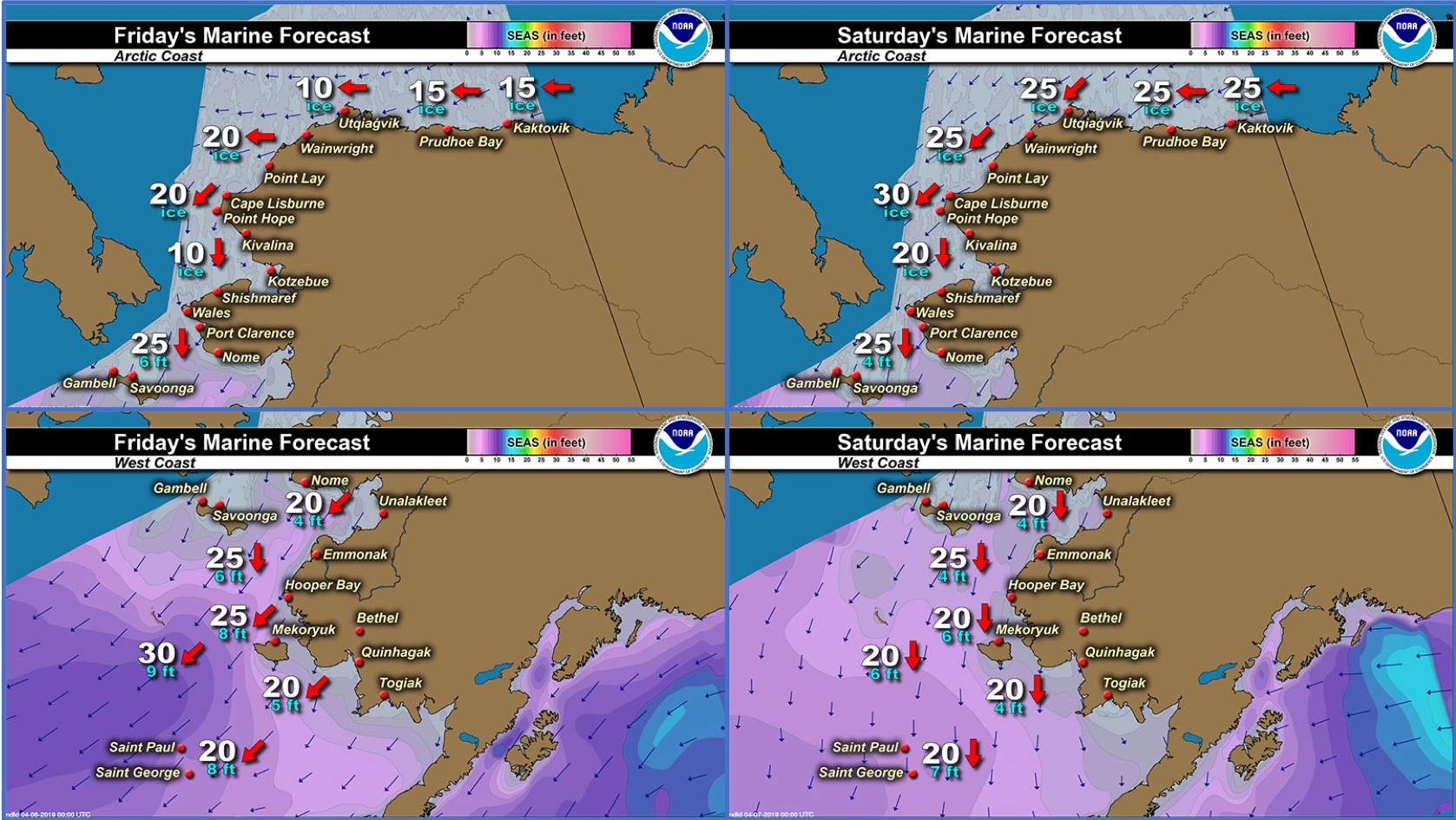
North to northeast winds 10 to 20 kt (11 to 23 mph) on Friday, April 5th will increase to 20 to 30 kt (23 to 35 mph) on Saturday, April 6th from Little Diomede/Wales to St. Lawrence Island. The winds will remain east to northeast 10 to 15 kt (11 to 17 mph) around Nome and Shishmaref through Monday, April 8th, but diminish to northeast 15 to 20 kt (17 to 23 mph) from Little Diomede/Wales to St. Lawrence Island on Monday. Winds will become east to northeast 5 to 15 kt (5 to 11 mph) by Tuesday, April 9th, with the strongest winds remaining from Diomede to St. Lawrence Island. Winds will shift to the east to southeast 15 to 25 kt (17 to 29 mph) on Wednesday, April 10th and persist through Friday, April 12th. Periods of stronger winds to 30 kt (35 mph) are possible Wednesday through Friday over St. Lawrence Island.
Temperature Trend
High temperatures Friday, April 5th through Friday, April 12th will generally be in the 20's except into the lower 30's around Nome. Low temperatures will mainly be in the mid teens to upper 20's Friday, April 5th through Friday, April 12th, with coldest temperatures through the Bering Strait.
Daily Weather, Wind, and Temperature Updates
The National Weather Service provides twice-daily, text only updates on the weather, wind, and temperature conditions in specific geographical zones. An interactive weather map for access to other Alaskan zones can be found here: http://weather.gov/anchorage/ice
Wind maps are updated daily and can be viewed here: http://www.weather.gov/afg/SIWO_overview
Marine forecast for the West Coast and Arctic Coast
Remote Sensing Images


Observations and Comments
Observations of Sea Ice Development
Observations from Gambell
5 April 2019 – Clarence Irrigoo, Jr.
The last photo you could see the village of Gambell, we went about 3-4 miles.
[video:]


Observations from Wales
5 April 2019 – Robert Tokeinna, Jr.
This week we were bounded by ice fog for most of the week with northerly winds. The ice appears to be flow ice, but there is some shorefast ice on the point as seen in the pictures. I flew in from Nome yesterday and seen the ice in Port Clarence Bay to be still intact, but pretty much open from there all the way to past Ikpik Lagoon. Open water from Wales to Diomede Islands too. There are small snow birds and sea gulls lingering in town meaning spring is here to stay. Not much traffic on the ice, but I seen postings on social media of friends in Brevig are catching seals. Winds were predominantly north winds with temperatures staying above freezing. The local road clearing crew broke trail from the airport to north side of town. This ends my report.


Observations from Savoonga
5 April 2019 – Aqef Waghiyi
No open water for 2-3 days. Broken up ice and small chunks of ice. Some pieces big enough for walrus and seals. Seen some walrus on the ice but no way of getting to them. The ice is all bunched up with no open leads. Few days ago, went boating two days in a row and got walrus. Only seen one female. The rest were males.


Observations from Port Clarence and Brevig Mission
4 April 2019 – Marcus Barr
The ice edge opened up closed about 1/4-1/2 mile closer. Ice is breaking up daily. Some of the hunters are hunting bearded seal now. 2nd day locals saw beluga at the ice edge. The shore fast ice is going out fast with the north winds.


Observations from Nome
3 April 2019 – Boogles Johnson
The ice is now leaving again our continued winds will push the ice out creating excellent hunting opportunities. The weather is cooperating for those who have their boats ready. Its a month early and not stopping.


Observations from Shishmaref
4 April 2019 – Curtis Nayokpuk
Heard hundreds of "Se-tuak" (white whale) passing Wales. Not much new ice /slush this morning along shoreline so even with nightly temps dropping to low 20's ocean not freezing as much. Forecast is northerly winds next few days so going out hunting Caribou as reports are they are moving north early too.
Additional Comments Provided by Local Experts and Other Contributors
Additional satellite resources:
")

From Mary-Beth Schreck, Sea Ice Program Leader, NWS Alaska Sea Ice Program
"The main thing to notice is that there is new sea ice forming in several areas now that those northerly winds have developed. I tried to point out where those areas are on the image. New sea ice growth is expected to continue at least into the middle of this week, as noted in the sea ice outlook we did Thursday."
