
Assessment of Current Ice Conditions Relevant to Distribution and Access of Walrus
Near St. Lawrence Island
The shorefast ice along the northern coastline of the island continues to be limited in extent, currently extending up to 8 miles offshore, while the shorefast ice along the southern coastline is limited to the lagoons. To the north and east of the island lies a region of very close pack ice consisting of mainly first year ice floes. To the west and south of the island lies an area covered mainly with young and new ice with isolated first year ice floes in the vicinity.
Wales to Shishmaref
Shorefast ice along the northwest Seward Peninsula beyond the lagoons does not appear to be quite as stable this year as some years in the recent past. The edge of the shorefast ice currently extends 13 miles off the coast from Mugisitokiwik, 13 miles from Ikpek, and is limited to the extent of the lagoons near Shishmaref. Sea ice continues to be mobile through the Bering Strait with close pack ice consisting of first year ice floes. Compact pack ice lies off the coast from Shishmaref to Kotzebue Sound with an area of new and young ice, along with isolated first year ice floes from Ikpek to the Bering Strait.
5 to 10 Day Forecast
Weather System/Wind Synopsis
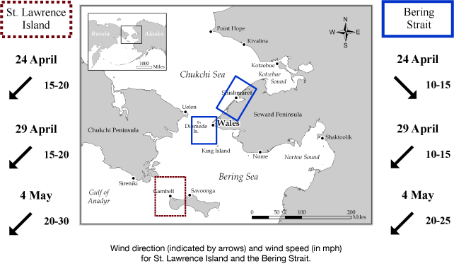
A low near Bristol Bay will bring north to northeast winds 10 to 15 kt (15 to 20 mph) Friday, 24 April. The low will move into the southern Gulf of Alaska on Saturday, 25 April, bringing northwest winds of around 10 kt (15 mph). Another low moves into the southern Bering Sea Sunday the 26th with light and variable winds of 10 kt (15 mph). Monday, as the low strengthens in the southern Bering Sea, the winds become southeast at 10 kt (15 mph) near St. Lawrence Island and variable at 10 kt (15 mph) in the Bering Strait. That low moves quickly east of the Bering Sea Monday night and is replaced by another in the southwest Bering Sea Tuesday with east winds around 10 kt (15 mph). The low strengthens a bit in the southern Bering Sea Wednesday the 29th with northeast winds of 10 to 15 kt (15 to 20 mph). The low continues to strengthen near Adak with winds of 10 to 20 kt (15 to 25 mph). By Friday May 1st, the low moves near Unalaska. Northeast winds of 10 to 20 kt (15 to 25 mph) persist. The low moves slowly to Cold Bay Saturday, 2 May, with northeast winds of 15 to 25 kt (20 to 30 mph). The low moves a bit east of Cold Bay Sunday the 3rd with continued northeast winds of 15 to 25 kt (20 to 30 mph). High pressure builds into the Chukchi Sea Monday, 4 May, with a low in the Gulf of Alaska. Winds will continue from the northeast at 15 to 25 kt (20 to 30 mph).
Temperature Trend & Ice Forecast
Temperatures will be 5 to 10 degrees above normal with daytime temperatures around 30 to 40 degrees. Overnight temperatures of 20 to 30 degrees are anticipated, except around Kotzebue Sound where they will be in the teens.
Since the majority of the wind direction will be east and northeast during this period, we expect that sea ice will continue to compact along the northern coastline of St. Lawrence Island with the polynya along the south and west-facing coastline expanding. During this time the shorefast ice edge from Wales to Shishmaref and ice floes near Wales along the Bering Strait will shift out into the Bering Strait and south into the northern Bering Sea.
Marine forecast for the West Coast and Arctic Coast
Remote Sensing Images


Observations and Comments
Observations of Sea Ice Development
The NOAA/NWS Sea Ice Desk contributed additional satellite imaging with clearer conditions, dated 25 April 2015:


