
Assessment of Current Ice Conditions Relevant to Distribution and Access of Walrus
State of the Ice at Season’s Start
Analysts at the Alaska Ice Program cannot recall a time in recent memory when the ice around the Bering Strait was so broken up this early in the year. Compared to the extreme ice year of 2013, there is less ice over the Gulf of Anadyr; there is even less ice in that region than in 2014. Figures 1-3, below, show that there is less ice in the area than at this time of year in 2013 and 2014. Given the current state of the ice and the forecast by the Climate Prediction Center for a good chance of warmer than normal conditions, ice may be out of the area faster than the past 2 years.


There is very limited shorefast ice along the north coast of St. Lawrence Island, and on the southern coastline of the island shorefast ice is nearly nonexistent.
Satellite imagery from earlier this year shows the presence of shorefast ice along Shishmaref from 10 February 2015 through its disappearance on 26-28 February when south winds were reported to have blown most of it out to sea. Currently, the shorefast ice beyond the barrier islands from Wales to Espenberg is less stable than we would generally expect for this time of year. Additionally, it would typically extend out much further from the islands and be grounded on a shoal between Wales and Shishmaref, but this year the consolidated ice pack started to form in early March.
While these conditions are not typical, there have been a few occasions in the past 20 years or so where ice has been similarly lacking. The range of shorefast sea ice extent in March is represented in Figure 4 (below), and can be compared with Figure 5, an early March 2015 satellite image.
 ice extent is much further from shore, grounded on a shoal between Wales and Shishmaref. However, extreme minimum extent with very little or no shorefast ice has occurred in the past 20 years or so.")

Near St. Lawrence Island
Satellite imagery shows minimal shorefast ice extent along the northern coast of St. Lawrence Island compared to recent years. The shorefast ice along the northern coastline of the island currently extends up to 8 miles offshore, while the shorefast ice along the southern coastline is limited to the lagoons. Beyond the shorefast ice edge to the north and east of the island lies a region of close to very close pack ice consisting mainly of first year ice floes. To the south of the island beyond the lagoons and along the west facing coastline lies a polynya that has frozen over with new and young sea ice extending 5 to 50 miles to the southwest.
Wales to Shishmaref
The shorefast ice along the coast from Shishmaref up to Kotzebue Sound is limited to the barrier islands at this time. A region of consolidated first year ice has formed in the past month along the coast from Wales to Shishmaref extending up to 14 miles beyond the barrier islands. Beyond the consolidated pack lies a region of close to very close pack ice consisting mainly of first year ice floes. It is notable that the ice floes in the vicinity of the Bering Strait have been very mobile this winter ice season.
5 to 10 Day Forecast
Weather System/Wind Synopsis
NOTE: Wind directions are given using the direction from which they originate. Therefore, an ‘east wind’ will be blowing from the east to the west.
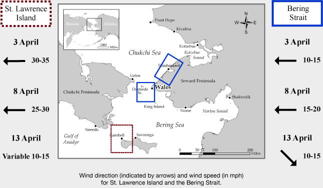
High pressure over the Bering Sea with a low over the Kamchatka Peninsula will give way to a low in the central Bering Sea on Friday, 3 April. This will create east wind of 10 kt (15 mph) in the Bering Strait and near-30 kt (35 mph) at St. Lawrence Island. The low will move to the Kuskokwim Bay on Saturday, 4 April, with winds diminishing a bit over the area to near 20 kt (25 mph) around St. Lawrence Island. Another low moves into the Bering Sea on Sunday the 5th, with east winds around 10 to 15 kt (15 to 20 mph) around the Bering Strait and up to 30 kt (35 mph) near St. Lawrence Island. The low swings to Bristol Bay with winds increasing to northeast at 15 kt (20 mph) around the Bering Strait to 35 kt (40 mph) near St. Lawrence Island on Monday, 6 April. On the 7th, the low continues to move into the Gulf of Alaska with another low moving to the Kamchatka Peninsula creating north winds of 10 kt (15 mph) through the Bering Strait and 15 kt (20 mph) around St. Lawrence Island. It then moves into the western Bering Sea with east to northeast winds of 10 to 20 kt (20 to 30 mph) Wednesday the 8th, and continues to St. Lawrence Island on the 9th with light east winds (<10 kt, <15 mph). The low weakens and moves inland Friday, 10 April, with north winds developing at 10 to 20 kt (15 to 25 mph). As the low weakens over land through next weekend (11-13 April), the winds will become weak and turn to the north and northwest (<10 kt, <15 mph).
Ice Forecast & Temperature Trend
With the winds over the Bering Strait and St. Lawrence Island region persisting out of the East to North through much of this period, we expect that much of the ice north of St. Lawrence Island will compact along the northern and western coastlines, while the polynya along the south and west coast of the island expands. Along the Wales to Shishmaref coast it is possible that the compact ice beyond the barrier islands could destabilize and shift towards the west during periods of easterly wind flow in the first part of the forecast period. As the winds become northerly it is likely that the pack ice will once again compact near the coastline.
Outside of Tuesday and Wednesday (7-8 April), the temperatures will be 5-10 degrees above normal. The overnight lows will be from 15-25 ˚F with daytime maximums of 25-35 ˚F. On Tuesday and Wednesday, the minimums will be 5-15 ˚F with daytime maximums in the 20s.
Marine forecast for the West Coast and Arctic Coast
Remote Sensing Images


Observations and Comments
Observations of Sea Ice Development
Observations from Gambell
3 April 2015 - Vera Metcalf, Eskimo Walrus Commission
Whaling started in Gambell earlier this year. Not sure about Savoonga yet where hunting is done south side of the island.
Observations from Nome
3 April 2015 - Fred Tocktoo
Constant strong northerly and warm winds kept Nome's shorefast ice from forming until late February and finally in early March Nome was able to see some small pressure ridges forming beyond quarter to half a mile from shore. From then on, temps started getting colder and by mid-March shorefast ice was stable for winter crabbing around Nome's shores. Beyond half a mile or more, ice is in constant movement, going back and forth. Less snow fell this winter compared to years past here at Nome.
Observations from Savoonga
3 April 2015 - Dean Kulowiyi
The ice is pretty thin right now. There were openings in the ice occurring on and off over the winter. Yesterday there were people out on boats from the south side, but changing wind conditions are affecting whaling activities.
Observations from Wales
31 March 2015 - Winton Weyapuk, Jr.
There is extensive pack ice with no leads or ponds visible. A whaling captain said one of his daughters saw the spouts of two bowhead whales in a lead yesterday. One of his crew members also saw a bowhead whale surfacing in a lead a couple of days ago.