
Assessment of Current Ice Conditions Relevant to Distribution and Access of Walrus
Near Saint Lawrence Island
Persistent northeast winds through April 28th continued to push large floes south into Saint Lawrence Island, especially around and to the east of Savoonga. These winds have also kept concentrations of the large floes 10-25 miles west of Saint Lawrence Island and more than 40 miles to the south of Saint Lawrence Island. The sea ice was generally drifting south through the 28th. Westerly winds on the 29th modified the flow slightly, but this change will be brief. Closer to shore, new ice continued to reform in the polynyas, however, satellite imagery indicates that the concentration of new ice is less than a few days ago.
Wales to Shishmaref
The landfast ice has persisted the last week, with relatively small changes from Wales to Shishmaref. The shorefast ice remains heavily fractured with many leads. Northerly winds had kept pack ice close to the shorefast ice until recently. A reversal of the winds the last few days has caused the pack ice to drift north causing the waters to open up to a few miles in width.
5 and 10 Day Outlook: April 30 through May 10
The overall pattern will be persistent for the 5 and 10 day outlook. A general high pressure is expected to linger to the north. This will maintain east to northeast winds, with perhaps a short-lived reversal to northwest flow. Temperatures will also remain at or slightly below seasonable. As a result, little change is expected in sea ice conditions. Pack ice will continue to push up against the landfast ice between Wales and Shishmaref, with many leads. Temperatures will also likely favor formation of new ice. The polynya around Saint Lawrence Island will be maintained, with the larger flows remaining more than 20 miles south of the island. Ice will push up against the northside of Saint Lawrence Island, and flow around the west and east sides. As a result, the large floes will remain close to Gambell, but will flow away from the west side of Saint Lawrence Island.
Note about the dates of the Remote Sensing Data
There was not a very good recent satellite image available for Bering Strait (Wales), so the bigger view is from April 26th, which shows a nice shot of the sea ice conditions. The more zoomed in view takes a better look at Saint Lawrence Island since it was cloudy up by Wales.
Arrows show wind direction and wind speed in knots


Remote Sensing Images


Observations and Comments
Observations of Sea Ice Development
29 April 2010 - Hajo Eicken - Information on Landfast Ice North of Wales and Shishmaref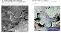 The radar satellite image (left side of image on right; see also image shown for outlook on 16 April 2010) shows that the landfast ice described by Curtis Nayokpuk on 5 April is still held in place by ridged ice that ran aground. However, the eastern parts of this stretch of shorefast ice are continuing to break out, giving Shishmaref closer access to open water (right side of image on right).
29 April 2010 - Hajo Eicken - Information on Landfast Ice North of Wales and Shishmaref
The radar satellite image (left side of image on right; see also image shown for outlook on 16 April 2010) shows that the landfast ice described by Curtis Nayokpuk on 5 April is still held in place by ridged ice that ran aground. However, the eastern parts of this stretch of shorefast ice are continuing to break out, giving Shishmaref closer access to open water (right side of image on right).