Assessment of Current Ice Conditions Relevant to Distribution and Access of Walrus
Wales to Shishmaref
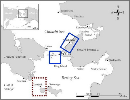
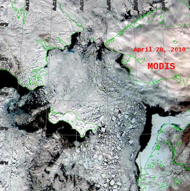
The storms of early to mid April significantly reduced the shorefast ice near Wales. The ice edge continues to erode slowly. There is open water along the shorefast ice. Further offshore of the shorefast ice and open water there is a lot of new, young ice extending out to 10 miles or more. Clouds cover the ice north of Shishmaref, but breaks in the clouds indicate that the shorefast ice is heavily fractured and has many leads, and that strong southerly winds could break down this ice very rapidly the next time they occur. At present, the northerly winds have pushed the pack ice up against the shorefast ice, but it is not consolidated. There are many large leads with open water; others have new ice. Temperatures continue to remain normal for this time of year.
Near St. Lawrence Island
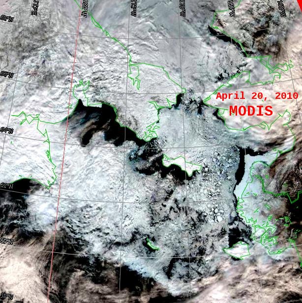
The sea ice continues to show the impacts of the several storms that brought south to southeast winds to the northern Bering Sea in early to mid April. The pack ice is loose and unconsolidated, especially between St. Lawrence Island and the Alaskan mainland coast. This ice has many broken floes that were in the central Bering Sea and pushed northeastward by the winds where it mixed with rounded floes. Since then the sea ice east of St. Lawrence Island has moved northward with the ocean current. The current has been sufficient to overcome the northerly winds. Sea ice has moved southwest of St. Lawrence due to steady northeasterly winds. This has resulted in large areas of open water and young, new ice. North of St. Lawrence the pack ice has pushed down against the coast, but there are many leads, some with new ice and some with open water.
5 and 10 day Outlook: April 23 through May 3
The general weather pattern starting the 23rd through the 25th will be north to northeast winds. There will be no major changes to the present ice conditions through the 25th. Ice will continue to be pushed south to southwest through the Bering Strait and west of Gambell. A low pressure system will move northward out of the Gulf of Alaska into the western mainland on the 26th and winds will increase and become more northwesterly over the northern Bering Sea and Bering Strait. These winds will be strong enough to push the sea ice east of St. Lawrence Island southward. In addition, ice will continue to push up along the north shore of St. Lawrence Island. Winds become more west to southwesterly on the 29th, weakening on the 30th and remaining weak through the 3rd.
Arrows show wind direction and wind speed in knots


Remote Sensing Images


Observations and Comments
Observations of Sea Ice Development
29 April 2010 - Kenneth Stenek, Shishmaref
The triangle of ice out from Ikpik is a pretty annual occurrence. In fact when I drove my boat around the peninsula on the 14th of June 2008 from Nome, that was one of the things I was waiting for to break up. The ice around Shishmaref was broken up but not really moving around. We were slowed by ice floes this side of Sitnasauq (Shishmaref side of Ikpik) but were able to move around as the ice moved with tides. It is really amazing how flat the ice is this year, there are no large pressure ridges that I can see (>3m). There are smaller pressure ridges but nothing that really stands out. We will see what that means this spring.
29 April 2010 - Curtis Nayokpuk, Shishmaref
Two hunters reported Monday April 26th on recon to open water along main ice edge sighting 3 oogruks [bearded seal] on the floating broken ice 12 miles west of Shishmaref. Also observed one going up on the ice but returned into water. They ended up at that location (westerly) due to rough ice and could not find a good trail to haul boats. One other hunter reported encountering rough ice a few miles north of town and a smoother route for hauling boats beyond that to a location approximately 8 miles to main ice edge. They all said conditions are poor for boating or retrieving oogruks (with drag hooks) due to new thin ice or freezing water surface on open leads. These oogruk and lone walrus are probably following open lead during south wind last week from the tip of Wales Shoal (land fast ice) into waters north of Shishmaref and east on to Kotzebue Sound.
29 April 2010 - Kenneth Stenek, Shishmaref
The triangle of ice out from Ikpik is a pretty annual occurrence. In fact when I drove my boat around the peninsula on the 14th of June 2008 from Nome, that was one of the things I was waiting for to break up. The ice around Shishmaref was broken up but not really moving around. We were slowed by ice floes this side of Sitnasauq (Shishmaref side of Ikpik) but were able to move around as the ice moved with tides. It is really amazing how flat the ice is this year, there are no large pressure ridges that I can see (>3m). There are smaller pressure ridges but nothing that really stands out. We will see what that means this spring.
29 April 2010 - Carleton Ray, Virginia
It appears that the "mixing bowl" is in full effect. "Mixing bowl" is a word I adopted from "Imarpik", for the Bering Sea, given during a presentation by a lady from Bethel at a conference I attended. It signifies a condition whereby four recent strong storms have mixed-up seascape types (habitats for marine mammals and others) such that the types have apparently become incoherent. The bottom line is that the entire western Bering ice looks like a pile of mush from space, so to speak. Thus, for walruses, "broken pack", their preferred seascape type, is not readily discernible.
As a result of such mixing, there is a good chance that the migrating walrus -- specifically, the first wave to pass St. Lawrence -- are in scattered ice between St. Lawrence Island and Provideniya, but mostly over the date line. Surely, their usual pattern would be that by now the migration is well underway. The majority of calves should emerge in the next two weeks.
As for the eastern group, walruses might be at about 59.5 N and 170 W to northward of St. Matthew. That group constitutes the "second wave" that passes St. Lawrence late May-early June, and from the looks of it, I would venture a guess that they would head NW and pass St. Lawrence on the west, not both east and west as sometimes happens, like in 2008, by about the second to third week of May.
These are off-the-cuff guesses, based on our shipboard observations from 2006 through 2009, but not substantiated by direct observations this year.
