Outlook Report
Executive Summary
We express our thanks to all the groups and individuals who submitted their contribution to the 2022 July Sea Ice Outlook (SIO) report and for your continued support.
We received 30 contributions of September sea-ice extent that included pan-Arctic predictions, 10 from dynamical models, 19 from statistical models and one based on heuristic methods. Of the 30, nine also included predictions for pan-Antarctic extent and eight included predictions for the Alaska Region (Bering, Chukchi, and Beaufort seas). There were 12 submissions of September mean Arctic sea-ice extent anomalies, computed relative to baseline trends from each prediction method. This practice, started last year, is motivated by the large spread in SIO predictions of mean September sea-ice extent. The intent is to examine if the spread is reduced when the inter-model bias is removed. For Alaska regional sea-ice extent, there were forecasts from five statistical methods and three based on dynamical models.
For the Arctic, the median July Outlook for September 2022 median pan-Arctic sea-ice extent is 4.64 million square kilometers, slightly higher than the median cited in the June report of 4.57 million square kilometers. Predictions based on the 19 statistical models have a median of 4.65 million square kilometers, while those from the ten dynamical models have a median of 4.65 million square kilometers. The one prediction from the heuristic approach is 4.25 million square kilometers. Overall, predicted values are similar to those reported in the June 2022 outlook. None of the predictions are for a new record low extent. The 12 anomaly forecasts ranged from -0.26 to +0.91 million square kilometers, with ten above and two below the contributors' baseline. The July SIO anomaly forecast range spans 1.2 million square kilometers compared to the June SIO which had a range of 1.6 million square kilometers.
Compared to the June SIO SIP forecasts, the July SIO Sea Ice Probability forecasts show similar patterns and differences across models, although there is remarkable agreement in the location of the ice edge in the Beaufort and Chukchi seas, which in other years have shown more forecast uncertainty. By contrast, in the Laptev and East Siberian seas, there is a large spread between the forecasts—some models showing little ice and others more extensive ice. There is strong agreement that the Northern Sea Route will be open, but less agreement as to whether the southern Northwest Passage route will be open.
For the Alaska regional sea-ice extent, the median prediction is 0.57 million square kilometers with values ranging from 0.46 to 0.80 million square kilometers, all above the median sea-ice extent over the 2007–2021 period of 0.40 million square kilometers.
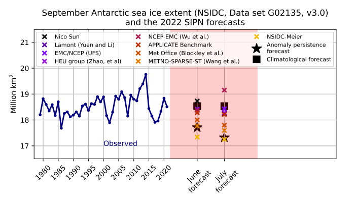
For the Antarctic, six of the nine submissions used statistical/machine learning methods, and three employed dynamical models. As reported in the June 2022 SIO, there is a narrow spread in the forecasts compared to previous years: the forecast range (1.90 million square kilometers) is smaller than the observed range (2.08 million square kilometers), though the forecast range for July is substantially higher than the range for June (1.39 million square kilometers). In 2017–2021, the range (max-min) of the ensemble of forecasts often exceeded twice the range of observed historical records. The median value of the forecasted September Antarctic sea-ice extent is 18.24 million square kilometers. It is thus expected that September sea-ice extent will be below the climatological average. As of this report, Antarctic extent is near a record low for this time of year.
This July Outlook Report was developed by lead author Mark Serreze, National Snow and Ice Data Center (NSIDC; Executive Summary, Overview, and discussion of Current Conditions); with contributions from Uma Bhatt, University of Alaska Fairbanks (discussion of pan-Arctic anomaly sea-ice forecasts and ice conditions in the Bering and Chukchi seas); Edward Blanchard-Wrigglesworth, University of Washington (discussion of predictions from spatial fields); Michael Steele, University of Washington, Applied Physics Laboratory (discussion of Ocean Heat Conditions); François Massonnet, Université catholique de Louvain (Discussion of Antarctic contributions; Matthew Fisher and the NSIDC Development Team, (statistics and graphs); Betsy Turner-Bogren, Helen Wiggins, Kuba Grzeda, Lisa Sheffield Guy, and Stacey Stoudt, ARCUS (report coordination and editing); and the rest of the SIPN2 Project Team.
Note: The Sea Ice Outlook provides an open process for those who are interested in Arctic sea ice to share predictions and ideas; the Outlook is not an operational forecast.
See: July Call for Contributions
2022 SIO Forecasts (Pan-Arctic, Alaska Region, Spatial Forecasts, and Antarctic)
Pan-Arctic Sea-Ice Forecasts
For the Arctic, the median July Outlook for September 2022 median pan-Arctic sea-ice extent is 4.64 million square kilometer (Figure 1), somewhat higher than the median cited in the June report of 4.57 million square kilometers. The interquartile range for the pan-Arctic predictions is 4.49 to 4.76 million square kilometers and the predictions range from a low of 3.96 million square kilometers to a high of 5.26 million square kilometers.
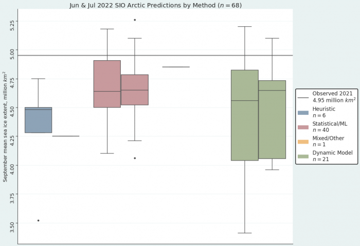
Looking now at results based on the different methods (Figure 2), predictions from the 10 dynamical models have a median of 4.65 million square kilometers and a interquartile range of 4.06 to 4.73 million square kilometers. The lowest prediction from the dynamical models is 3.96 million square kilometers and the highest is 5.10 millions square kilometers. Those from the 19 statistical methods have a median of 4.65 square kilometers, with an interquartile range of 4.52 to 4.79 million square kilometers. The lowest statistical prediction for July is 4.06 million square kilometers and the highest is 5.26 million square kilometers. The one prediction from the heuristic approach is 4.25 million square kilometers.
Overall, predicted values are similar to those reported in the June 2022 Outlook, with July’s median slightly higher. For the dynamical models, the median is somewhat higher in July compared to June 2022, but with a smaller spread. The same can be said for the statistical models, but the difference between June and July is much smaller. As has been pointed out numerous times before, the spread in predictions is considerably larger in the dynamical models compared to the statistical methods. The record low September extent over the period of satellite observations was set in 2012 at 3.57 million square kilometers, and the second lowest on record was 4.00 million square kilometers set in 2020. Hence, as was the case in 2021, none of the forecasts are for a new record low.
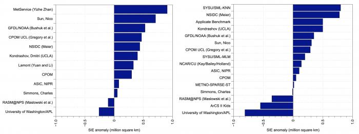
This is the second year that the SIO has solicited forecasts of September mean sea-ice extent anomalies. The anomaly is the departure of the contributors' September extent outlook relative to their adopted baseline trend (e.g., the trend in historical observations, model hindcasts, etc.), motivated by the prospect of reducing SIO extent forecast uncertainty that may originate from models having different trends, mean states, and post-processing methodologies. The 12 anomaly forecasts for July range from -0.26 to +0.91 million square kilometers, with ten above and two below the contributors' baseline (Figure 3, left). The July SIO anomaly forecast range spans 1.2 million square kilometers compared to the June SIO, which had a range of 1.6 million square kilometers (Figure 3, right). The pan-Arctic July SIO anomaly forecast has a median of 0.37 (June's median was 0.17) and a standard deviation of 0.33 (June standard deviation is 0.44) million square kilometers. The range and standard deviation of July forecasts is lower than the June forecasts and the median indicates that the July SIO anomaly forecasts for September 2022 are more positive than the June SIO.
Alaska Regional Forecasts
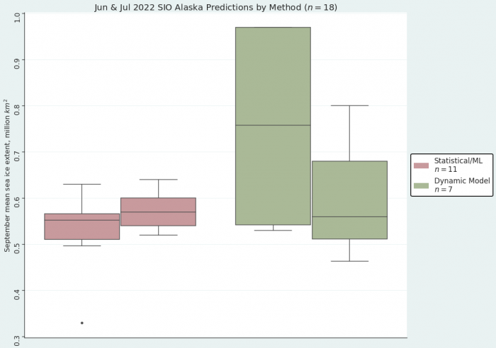
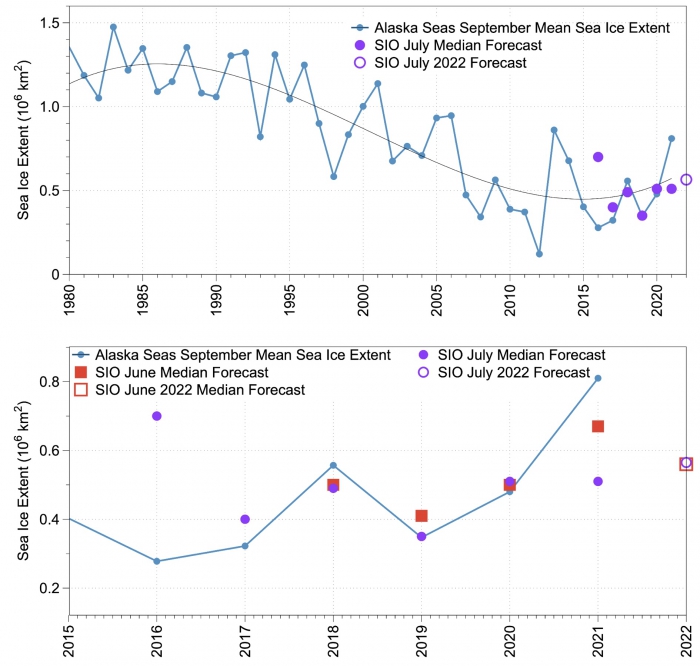
The multi-modal median for the July 2022 SIO forecast for the Alaska seas is 0.56 million square kilometers and consists of 8 contributions with values ranging from 0.46 to 0.8 million square kilometers (Figure 4). The dynamical model forecasts range from 0.4 to 0.8 million square kilometers with a median of 0.56 million square kilometers. The statistical model forecasts range from 0.52 to 0.57 million square kilometers with a median of 0.57 million square kilometers. The statistical forecasts display a smaller spread (standard deviation of 0.05) compared to the dynamical models (standard deviation of 0.17; Figure 5). The spread in the dynamical models is lower in the July SIO forecasts compared to those from June. To place these in historical perspective, the September median sea-ice extent for the averaged Alaska seas (Bering, Chukchi, and Beaufort) over 2007–2021 is 0.40 million square kilometers (Figure 6, top), making the forecast for 2022 above all observed values between 2015 and 2020 (Figure 6, bottom). June and July SIO median forecasts were close to observations in 2018, 2019, and 2020, while the 2021 forecast was much lower than observed (0.1 to 0.3 million square kilometers below observed).

Pan-Arctic Forecasts with Spatial Methods
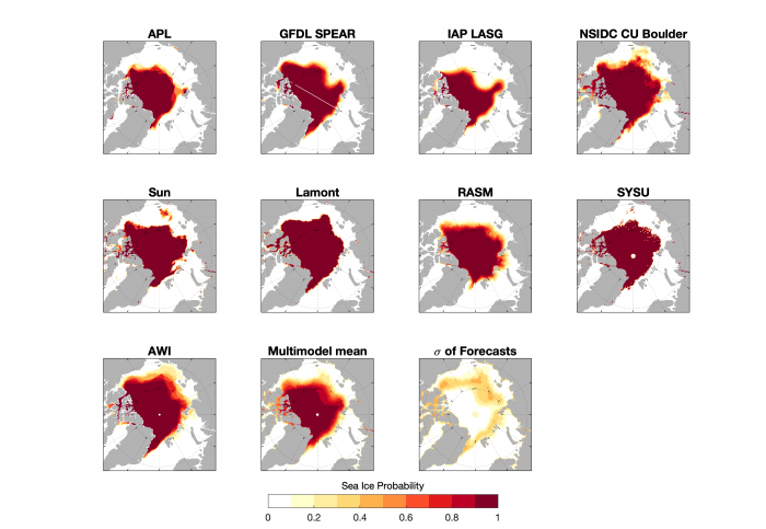
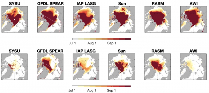
For the July SIO we received nine forecasts of Sea Ice Probability (SIP) and six forecasts of Ice-Free Date (IFD). To refresh the reader, SIP is defined as the fraction of ensemble members that project September Sea-Ice Concentration (SIC) in excess of 15% (for example, if just four out of eight ensemble members are higher than 15% concentration, the SIP is 50%). IFD is the first date in the melt season at which the ice concentration at a given location drops below a certain threshold (we use 15% SIC and 80% SIC thresholds).
Compared to the June SIO SIP forecasts, the July SIO SIP forecasts show similar patterns and differences across models, although there is remarkable agreement in the location of the September sea-ice edge in the Beaufort and Chukchi seas, which in other years have shown more forecast uncertainty. By contrast, the Laptev and East Siberian seas show more uncertainty, with some models showing low sea ice (APL, GFDL SPEAR, IAP LASG) and others more extensive conditions (AWI, NSIDC CU Boulder). There is, nevertheless, general agreement that the Northern Sea Route will be open, but less agreement as to whether the southern Northwest Passage route will be open (Figure 7).
Figure 8 shows IFD with 15% ice concentration cut-off (IFD15; top row) and 80% ice concentration cut-off (IFD80; bottom row) forecasts. Similar to June, there is significant uncertainty in IFD15 along the Arctic coasts, especially along the eastern Siberian coast (where forecasts range from an early July ice retreat to ice lingering into September). By contrast, the Kara and Barents regions show consistency across forecasts and very slow ice retreat. For the IFD80 forecasts, as in June, there is considerable model spread over the central Arctic Ocean, with some models forecasting complete loss of SIC>80% by September, while others are forecasting extensive SIC>80%.
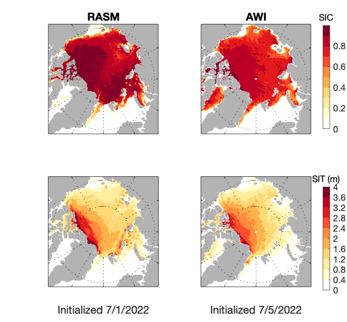
While we only have initial conditions from two models for the July SIO (Figure 9), it is worth noting that there is consistency in the sea-ice edge but differences in thickness and central Arctic SIC across the two models. The AWI model shows lower initial SIC values over the central Arctic relative to RASM. Initial ice thickness also shows large differences in the Laptev and Kara seas between the two models.
Antarctic Forecasts
For this second round of outlooks (July), all contributors have updated their forecasts compared to June. The distribution of forecasted sea-ice extent from the SIO contributions points to an anomalously low Antarctic ice extent for September. The June negative sea-ice extent anomaly (-1.21 million square kilometers) seems to have persisted through July (-1.06 million square kilometers as of July 13th; Figure 10).
Current Conditions
Pan-Arctic Conditions
Based on data from the NSIDC Sea Ice Index, average Arctic sea-ice extent for June 2022 was 10.86 million square kilometers, ranking tenth lowest in the 43-year satellite record. This was 900,000 square kilometers below the 1981 to 2010 average. The Barents Sea became nearly ice-free in June. Hudson Bay also lost most of its ice unusually early. Extent in the Chukchi, East Siberian, and Kara seas was slightly below average. The most notable feature along the Russian coast was the opening of a large polynya in the Laptev Sea near the New Siberian Islands. Baffin Bay had near average ice extent, and in early June the North Water Polynya opened. Some extensive low ice-concentration regions formed over the central Arctic Ocean.
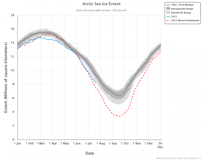
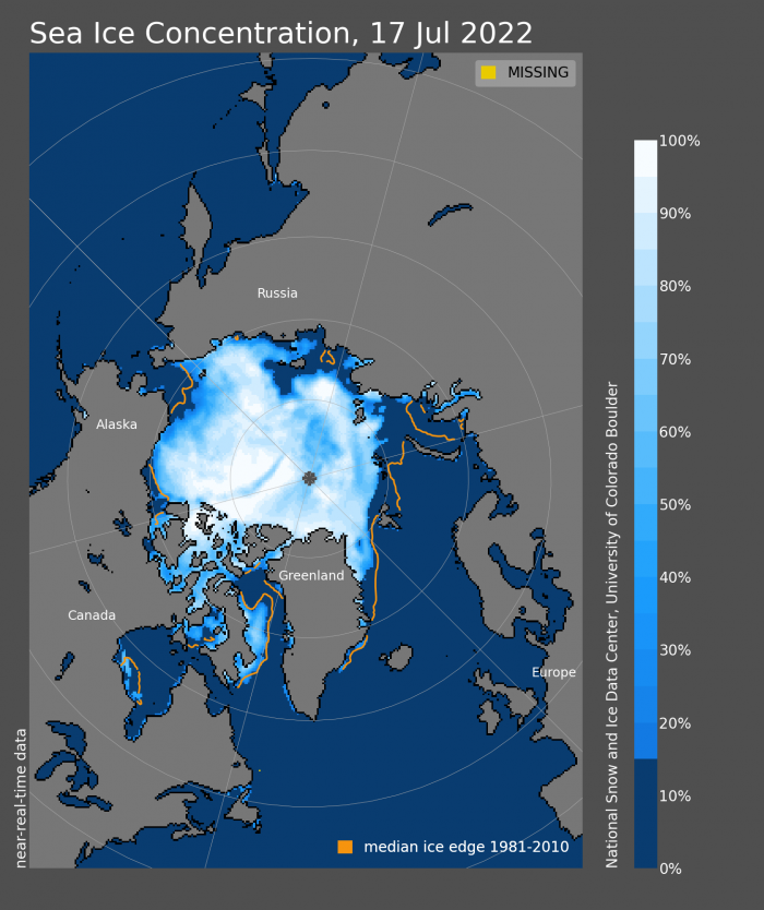
The daily decline in Arctic ice extent through the first half of July has been near the 1981–2010 average (Figure 11). The spatial patterns of ice conditions observed in June have persisted and further developed through the first half of July (Figure 12), with the most notable ice-loss in the Laptev Sea. This is similar to the pattern of the last two years, but much less extreme than observed in 2020 and 2021 when the Laptev Sea ice extent was at or near record low levels in June and July. As of this report, only a narrow ribbon of ice persists in Hudson Bay, and the ice edge is located well north of Svalbard. The Barents and Kara seas are completely ice-free.
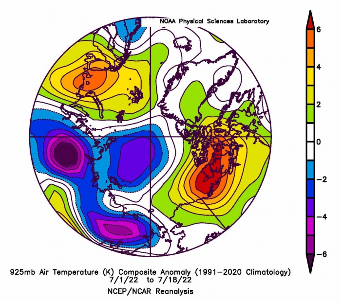
Temperature-wise, the first half July 2022 has been a tale of regional contrasts (Figure 13). On the Eurasian side of the Arctic, particularly in the Laptev and Barents seas, air temperatures at the 925 mb level (about 2500 feet above the surface) were 3 to 4 C (5 to 7 degrees F) below average. On the North American side of the Arctic, air temperatures were above average, notably in the southeast Beaufort Sea western Canadian Arctic Archipelago where temperatures were as much as 10 C (18 F) above typical values. Warm conditions in the Canadian Arctic Archipelago and associated clear skies have enhanced melt pond formation and evolution. The low ice concentration areas over the central Arctic Ocean have become more prominent.
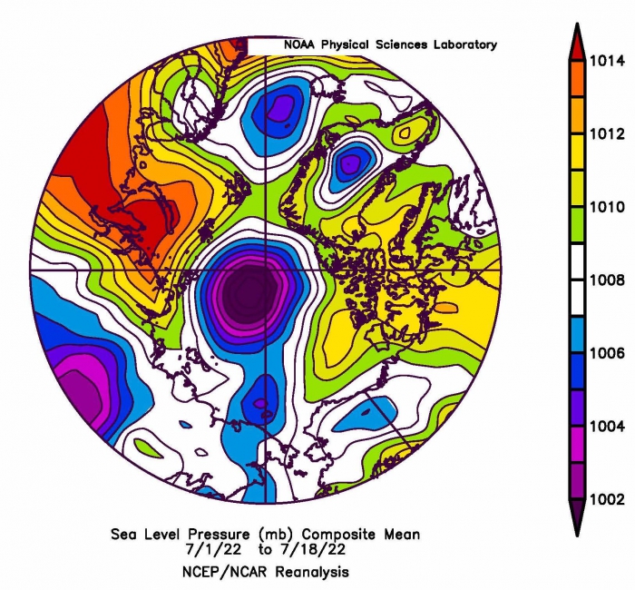
The sea-level pressure pattern through the first half of July was dominated by low pressure over much of the Arctic Ocean, centered near the North Pole (Figure 14). This type of pattern is common during the Arctic Ocean summer. Historically, such a pattern—if persisting through summer—tends to limit summer melt. However, questions have arisen as to whether this relationship holds in today’s warmer climate. Meridional (south to north) wind flow in the Barents Sea and north of Alaska support the two warm temperature maxima (Svalbard and northern Canada) on the southern boundaries of the Arctic Ocean, and the lack of sea ice in the Barents Sea.
Alaska Regional Conditions
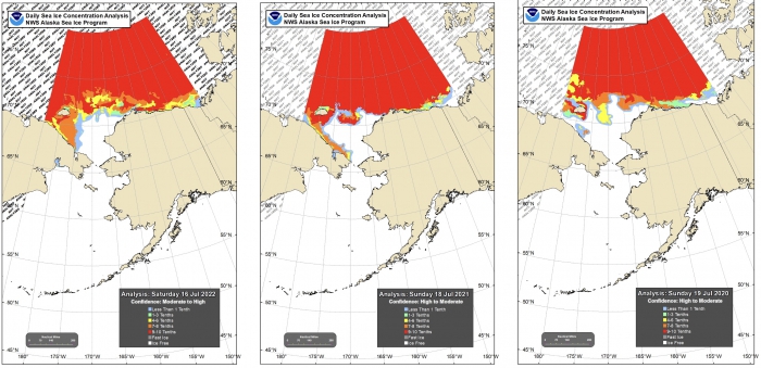
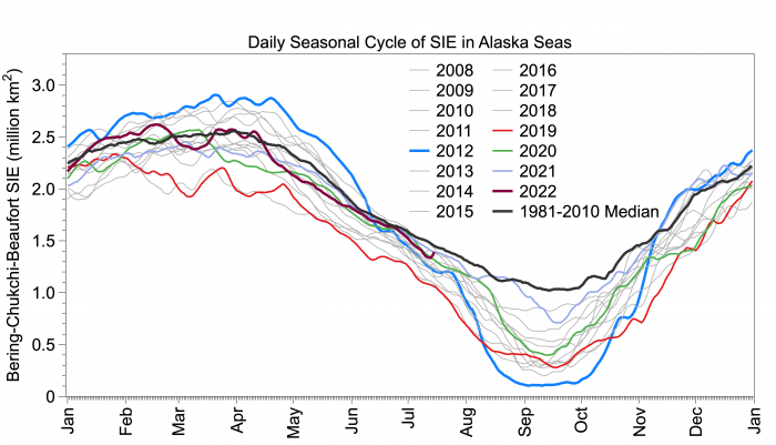
Mid-July 2022 sea-ice extent in the Chukchi Sea is similar to mid-July conditions of the previous two years, although there is more ice along Chukotka in 2022 (Figure 15, top). The eastern Beaufort has more sea ice in 2022 relative to 2021 or 2020. The combined Bering, Chukchi, and Beaufort sea-ice extent since mid-April 2022 continues to be slightly lower than the 1981–2010 average (Figure 15, bottom). The retreat during mid-April to mid-May was faster than the long-term median, but has remained close to the median rate in June and July 2022. The 15 June 2022 sea-ice extent in the Alaska seas was 1.39 million square kilometers and similar to this day in 2021 and higher than in 2020 (1.31 million square kilometers). The 15 July 2022 extent is slightly below the 1981–2010 median of 1.45 million square kilometers and above the 15 July 2019 sea-ice extent of 1.06 million square kilometers.
Ocean Heat Conditions
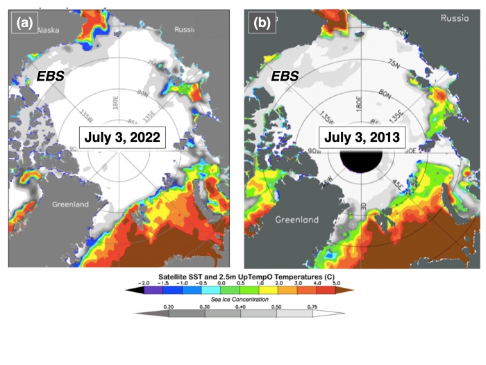
At the start of June 2022, most of the Arctic Ocean was still ice-covered and thus sea surface temperatures (SSTs) were near-freezing, with the exception of the Nordic seas, including the Barents. Over the past month, the usual sea-ice retreat patterns have allowed SSTs to begin increasing in the Chukchi, Laptev, and Kara seas, as well as in Baffin Bay. A notable lack of ice-opening and SST-warming is evident in the eastern Beaufort Sea—compared in Figure 16 to the year 2013—which experienced an unusual amount of multi-year sea-ice convergence into the region from the Canadian Arctic Archipelago (Mallett et al. 2021). Beaufort Sea ice convergence also happened in 2020 and 2021 (Moore et al. 2022) and led to anomalously high early-July ice concentrations and cool SSTs. These July 2022 conditions could lead to September 2022 conditions in the Beaufort Sea, similar to those recent years—extensive sea ice with a complex edge geometry and cool SSTs north of a coastal warm zone (see the 2021 SIO report).
Figure 17 shows SST anomalies for May 2022, just before summer sea-ice melting and ocean warming within the Arctic Ocean. The Bering and Nordic seas, where warm currents originate that influence Arctic Ocean sea-ice melt, were fairly close to recent average conditions (2000–2021), although perhaps above-average in the Alaskan Coastal Current south of the Seward Peninsula. Interestingly, to the south of these regions the North Pacific and North Atlantic oceans show strong positive anomalies. The disconnect between conditions at high- and mid-latitudes with respect to northward heat transport is a topic of much recent research (e.g., Tsubouchi et al. 2021). Figure 16 shows anomalies, so warm currents are certainly responsible for some early summer melt at the Pacific- and Atlantic-facing ice edges. However, this melt is likely not forced this year by anomalously warm currents.
SST color scale from NOAA OISSTv2.1
Figures above taken from UpTempO buoy website.
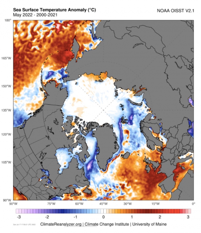
Figure above downloaded from ClimateReanalyzer.org
References
Mallett, R. D. C., J. C. Stroeve, S. B. Cornish, et al. 2021. Record winter winds in 2020/21 drove exceptional Arctic sea ice transport. Communications Earth & Environment 2, article #149. https://doi.org/10.1038/s43247-021-00221-8
Moore, G. W. K., M. Steele, A. S. Schweiger, J. Zhang, and K. L. Laidre. In review. Thick and old sea ice in the Beaufort Sea during summer 2020/21 was associated with enhanced transport. Communications Earth & Environment.
Tsubouchi, T., K. Våge, B. Hansen. et al. 2021. Increased ocean heat transport into the Nordic Seas and Arctic Ocean over the period 1993–2016. Nature Climate Change 11: 21–26. https://doi.org/10.1038/s41558-020-00941-3
Contributor Key Statements, Summary of Uncertainties
![]() Summary Table of Key Statements from Individual Outlooks (PDF - 140 KB)
Summary Table of Key Statements from Individual Outlooks (PDF - 140 KB)
Contributor Full Report PDFs and Supplemental Material
This report was developed by the SIPN2 Leadership Team
Report Lead
Mark Serreze, National Snow and Ice Data Center (NSIDC) Director, University of Colorado Boulder, NSIDC
Additional Contributors:
Matthew Fisher and the NSIDC Development Team, Cooperative Institute for Research in Environmental Sciences at the University of Colorado Boulder, NSIDC
Editors:
Betsy Turner-Bogren, ARCUS
Helen Wiggins, ARCUS
Kuba Grzeda, ARCUS
Stacey Stoudt, ARCUS
Lisa Sheffield Guy, ARCUS
Suggested Citation:
Serreze, M., U.S. Bhatt, P. Bieniek, E. Blanchard-Wrigglesworth, H. Eicken, M. Fisher, L. C. Hamilton, J. Little, F. Massonnet, W. Meier, J.E. Overland, M. Steele, J. Stroeve, J. Walsh, M. Wang, and H. V. Wiggins. Editors: Turner-Bogren, B., L., Sheffield Guy, J.K. Grzeda, S. Stoudt, and H. V. Wiggins. July 2022. "Sea Ice Outlook: 2022 July Report." (Published online at: https://www.arcus.org/sipn/sea-ice-outlook/2022/july.)
This Sea Ice Outlook Report is a product of the Sea Ice Prediction Network–Phase 2 (SIPN2), which is supported in part by the National Science Foundation under Grant No. OPP-1748308. Any opinions, findings, and conclusions or recommendations expressed in this material are those of the author(s) and do not necessarily reflect the views of the National Science Foundation.
