Table of Contents
- Section 1. Post-Season Highlights
- Section 2. Introduction/Overview
- Section 3. Review of Observed Arctic 2020 Conditions
- Section 3a. Observed Arctic Sea Ice
- Section 3b. Comparison of Sea Ice Extent Products
- Section 3c. Ocean Heat Conditions
- Section 3d: Discussion of 2020 Fall Ice Advance
- Section 3e: Atmospheric Conditions
- Section 4. Review of The 2020 Sea Ice Outlooks
- Section 4a. Overview of the 2020 Sea Ice Outlook (SIO)
- Section 4b. Review of Statistical Methods
- Section 4c. Review of Dynamical Models and Methods of Forecast Initialization
- Section 4d. Spatial Forecasts of September Sea Ice Extent Probability (SIP)
- Section 4e. Review of Regional Alaska Forecasts
- Section 5. Further Analysis of the Sea Ice Outlooks
- Section 5a. Probabilistic Assessment of the 2008-2020 Outlooks: Comparison between SIO Contributions and Control Forecasts
- Section 5b. Evaluation of SIO Forecast Skill Relative to Control Forecasts
- Section 5c. Results from SIO Contributors Survey
- Section 6. Discussion of Metrics
- Section 7. Discussion of Lessons Learned from SIO Contributors Forum
- Section 8. Sea Ice Forecasts for the Alaska Fishing Industry
- Section 9. Antarctic Contributions
- Section 10. Sea Ice Drift Forecast Experiment (SIDFEx) Results y
- Report Credits
- References
Section 1. Post-Season Highlights
The Sea Ice Outlook (SIO) is a community network activity led by the Sea Ice Prediction Network-Phase 2 (SIPN2) Project Team with contributions from key partners. SIPN2 is a community of scientists and stakeholders with the goal of advancing our understanding of the state and evolution of Arctic sea ice cover.
- The observed September monthly averaged sea-ice extent was 3.92 million square kilometers based on data from the National Snow and Ice Data Center (NSIDC) Sea Ice Index (SII).
- A total of 110 pan-Arctic September extent forecast submissions were received during the 2020 SIO season.
- The August median of SIO contributions, 4.30 million square kilometers, was closest to the observed September extent of 3.92 million square kilometers. The range of contributions to the August report were narrower providing a more precise forecast.
- The ice retreated far north, particularly in the East Siberian, Laptev, and Kara seas, where extreme above-normal spring temperatures lead to early melt onset and ice retreat in the region.
- The observed 2020 September extent in the Alaskan region had a total of 0.48 million square kilometers according to NSIDC, making it the 10th lowest of the combined Chukchi, Beaufort, and Bering seas.
- Analysis of a 13-year sample period from 2008–2020 revealed that the SIO forecasts have outperformed persistence and the persistence of the departure from the trend line (linear trend anomaly persistence).
- This season's networking activities included a SIO contributors survey to identify interests, and a two-day SIO Contributors Forum held in January 2021 to share successes and challenges of Arctic sea-ice prediction and identify network activities.
- 2020 Antarctic sea-ice extent reached 18.77 million square kilometers in September, which is the 13th highest out of 42 years and 0.24 million square kilometers above climatology. The SIPN South forecasts display a large spread and show better skill for statistical approaches than dynamical approaches for pan-Antarctic sea ice extent.
- 2020 was the fourth year of the Sea Ice Drift Forecast Experiment (SIDFEx), which forecasts seasonal ice drift associated with seven buoys of the International Arctic Buoy Program (IABP). Overall, the drift buoy forecast results indicate that ice drift predictability is limited—similar to its primary driver, the winds.
This 2020 Post-Season Sea Ice Outlook Report was developed by lead author Uma Bhatt, University of Alaska Fairbanks, Geophysical Institute (Report highlights, overview, and review of Regional Alaska Forecasts); Walt Meier, NSIDC (Observed Arctic Sea Ice, overview of the 2020 Sea Ice Outlook, and discussion of Arctic sea ice, discussion of metrics); Michael Steele, University of Washington (Discussion of ocean heat conditions); Muyin Wang, University of Washington (Review of statistical methods); Ed Blanchard-Wrigglesworth, University of Washington (Review of Dynamical Models and Methods of Forecast Initialization and Spatial Forecasts of September Sea Ice Extent Probability); John Walsh, International Arctic Research Center (Discussion of probabilistic assessment of the 2008–2020 SIOs); Larry Hamilton, University of New Hampshire (Discussion and evaluation of SIO forecast skill relative to control forecasts); Joseph Little, University of Alaska (Results from SIO Contributors Survey and discussion of sea-ice forecasts for the Alaska Fishing Industry); François Massonnet, Université Catholique de Louvain (Discussion of Antarctic contributions); Helge Goessling, Alfred-Wegener Institute (Discussion of SIDFEx results), Molly Hardman, NSIDC (Statistics and graphs); and Betsy Turner-Bogren and Helen Wiggins, ARCUS (report coordination and editing); and the rest of the SIPN2 Leadership Team.
Section 2. Introduction/Overview
The Sea Ice Prediction Network–Phase 2 (SIPN2) is a community of scientists and stakeholders with the goal of advancing our understanding of the state and evolution of the Arctic sea ice cover. The SIO is a community network activity led by the SIPN2 project team with contributions from key partners and the community. This Sea Ice Outlook (SIO) Post-Season Report provides in-depth analysis of factors impacting pan-Arctic September minimum sea ice extent this past summer, reviews of the 2020 SIOs, and discussions of the additional topics listed in the table of contents.
We are grateful for the excellent participation by contributors to the 2020 SIO to sustain this activity. This year we received a total of 110 submissions of pan-Arctic September extent forecasts. The full field analysis was facilitated by the SIPN sea ice forecast data portal that continuously collects forecasts, expanding the forecasts to other seasons beyond the September minimum. For SIO forecasts for the "Alaskan Region" (extent in the combined Chukchi, Bering, and Beaufort seas), we received a total of 28 contributions for the 2020 season.
Section 3. Review of Observed Arctic 2020 Conditions
Section 3a: Observed Arctic Sea Ice
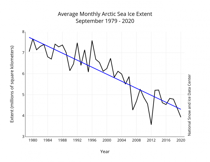
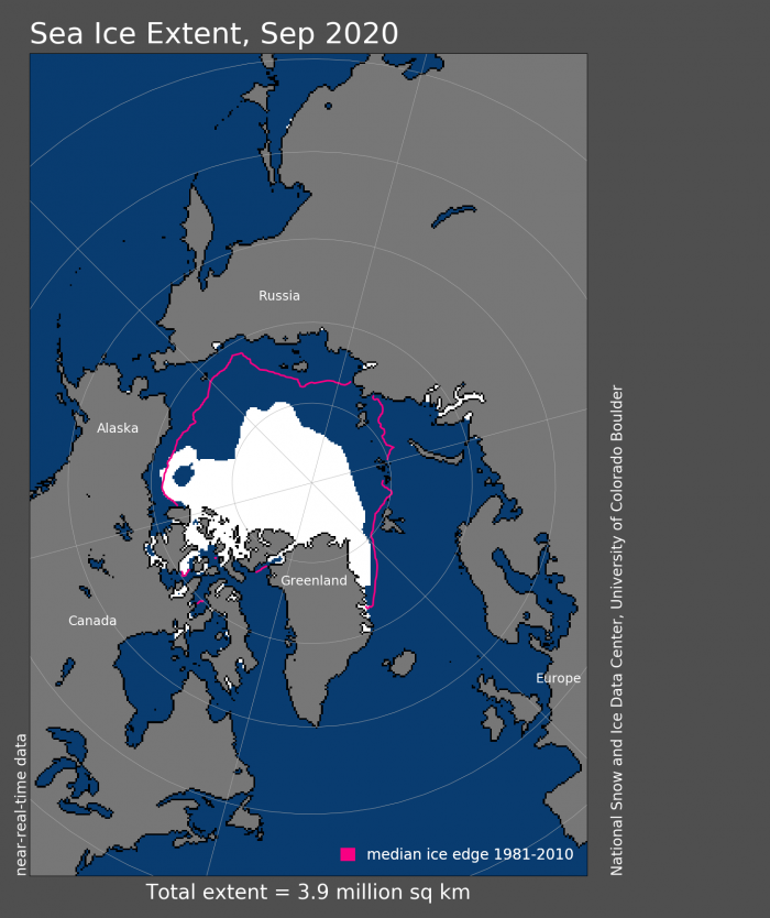
September Arctic sea ice was the second lowest in the satellite record (1979–2020), according to data from the NSIDC Sea Ice Index (SII, https://nsidc.org/data/seaice_index/, Fetterer et al., 2017). The average September 2020 extent was 3.92 million square kilometers (Figure 1), above the record low September extent of 3.57 million square kilometers in 2012, but 2.49 million square kilometers (39%) below the 1981–2010 climatological average. The 14 years between 2007 and 2020 are the lowest 14 September extents in the 42-year satellite record. The ice retreated far north around much of the Arctic (Figure 2), particularly in the East Siberian, Laptev, and Kara seas. These regions were marked by extreme above-normal temperatures for much of winter and spring, contributing to below normal ice growth in winter and to early melt onset and ice retreat in the region. In contrast to recent years, the Beaufort and Chukchi seas saw relatively slower ice retreat during the spring and early summer. However, by the end of summer, the Chukchi Sea was largely ice-free, while in the Beaufort Sea an arm of ice extended further south toward the coast than in most recent years.
Section 3b: Comparison of Sea Ice Extent Products
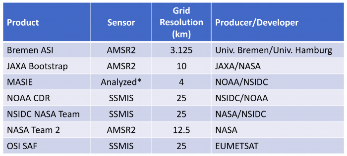
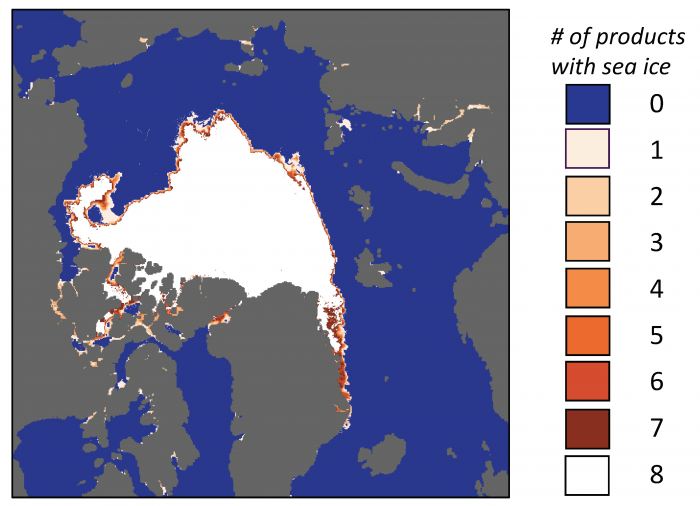
The Sea Ice Index is based on passive microwave satellite data using the NASA Team algorithm to derive concentration fields, and has been the standard observational baseline used in the Sea Ice Outlook. However, there are several other sea-ice extent products available, most based on passive microwave data, but using different sensors and/or methods. In the Interim Post-Season report, reported extents from some products were provided to give a broader, ensemble approach to the observed extent. Here, we have enhanced that analysis by harmonizing the products first—i.e., putting all the products on the same grid and using a consistent land mask for all fields (Table 1). Then, extent was calculated from the gridded concentrations using a 15% threshold for all products except MASIE (which uses 40%). Note that indications of ice in some scattered regions along the coast (e.g., along the Siberian coast and within the Canadian Archipelago) are due to sensor limitations along the coast where there is both land and open ocean within a sensor footprint; some of these areas may actually be ice-free even though ice is indicated (Figure 4).
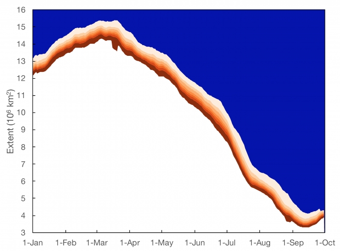
Throughout the year, the products show a substantial range of extent values of roughly one million square kilometers (Figure 3). These differences are a result of differences in the spatial resolution of the different sensors/sources used and the sensitivity of the algorithms to different ice characteristics, particularly thin ice and surface melt on the ice. Typically, the different products are off-sets from each other, i.e., relative biases, that carry throughout the time series. Thus, seasonal cycles and long-term trends and variability are generally consistent.
While the one million square kilometer range is notable, the discrepancies appear primarily at the ice edge and near the coast (Figure 4). This ensemble approach suggests a strategy of using ensemble extent fields to evaluate the Outlooks. One could use the median extent (area of where ≥ four products have ice) as the ensemble estimate and then the minimum (only where all eight products have ice) and maximum (where at least one product has ice) to provide a range of potential extent. This yields a median value of 3.75 million square kilometers for the 2020 September monthly mean, with a range of 3.49 to 4.39 million square kilometers (Table 2). Note that all SIO contributors prepare their forecasts in the context of the NSIDC Sea Ice Index and these other measures provide a greater understanding of the uncertainties around the SII.

Section 3c. Ocean Heat Conditions
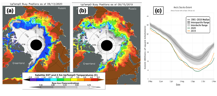
While there was a near-record sea-ice retreat in summer 2020, Arctic sea surface temperature (SST) showed an interesting spatial distribution by the time of the sea-ice minimum in mid-September, with a large swath of cold, near-freezing SSTs near the ice edge and much warmer temperatures immediately to the south in many areas. This was likely a function of the detailed nature of the ice retreat during mid/late summer. There was rapid retreat in early July (Figure 3 above) which exposed a large area of initially cold open water that slowly warmed via heat inputs from the atmosphere and from warm ocean currents. In late July and early August, ice retreat slowed considerably, but the exposed ocean continued to further warm. Finally, in late August and early September, sea-ice retreat accelerated again, as in early July. However, this time the newly exposed cold water was not able to appreciably warm above freezing, since the atmospheric heating at this late date is usually not significant. The result by mid-September was a band of exposed ocean with near-freezing SSTs, separated from warmer shelf water to the south by an unusually strong meridional front. This is illustrated in Figure 5, which contrasts the situation in 2020 (5a) with that in 2019 (5b), when ice retreat was more "normal" with early/mid-summer rapid retreat, then late-summer slower retreat until the sea-ice minimum (i.e., more like a sine wave). The result in mid-September 2019 was a much thinner band of cold, near-freezing water near the ice edge, with much weaker meridional SST gradients to the south toward the continental shelves. This analysis shows that the ocean responds quite strongly to seemingly small changes in the pace of sea-ice retreat. This response is often quite regional, with some areas retreating and warming much earlier than others.
Regionally, some areas' SSTs peaked in August (i.e., before the sea ice minimum: Baffin Bay, Barents Sea, Chukchi Sea, southern Beaufort Sea), while others continued to warm through the sea-ice minimum (Kara Sea, East Siberian Sea) and even up to a week later (Laptev Sea, West Spitzbergen Current). The Beaufort was a special, interesting case in summer 2020, with the multi-year sea-ice "tongue" (Figure 4 above) separating warm shelf water from a large northern area of late-melting, very cool water (Figure 5a).
Section 3d. Discussion of 2020 Fall Ice Advance
The year 2020 ended up with the second lowest September minimum ice extent in the satellite record, above only 2012. While Arctic air temperatures ranked as the highest recorded during both July and August, fostering strong melt, changes in the winds likely prevented the extent from falling below the 2012 record low.
While ice advance had a late start, once the ocean began to cool the ice growth occurred at a fairly rapid pace, and was especially brisk during the first part of November. Remarkably, on 24 October, Arctic sea-ice extent had its largest negative departure from the 1981 to 2010 average of daily sea ice extent in the 42-year continuous satellite record, at 3.4 million square kilometers (1.31 million square miles). The late start of ice advance resulted from extensive open water at summer's end, resulting in large amounts of stored heat in the ocean mixed layer, daily ice extents following the September minimum remained far below average. The monthly average ice extent for October was the lowest in the satellite record. Large heat transfers from the open water areas to the atmosphere as the ocean cooled were manifested as strongly above-average air temperatures near the surface of the ocean. This likely contributed to Arctic Amplification—the larger rise in air temperatures over the Arctic compared to the rest of the globe.
By November, the Northern Sea Route had iced over. However, extent remained especially low over both the Barents and Kara seas on the Atlantic side and the Chukchi Sea on the Pacific side of the Arctic. This basic pattern, which points to influences of oceanic heat inflow, persisted through the end of the year. Despite the rapid ice growth during the first part of November, the November average extent of 8.99 million square kilometers (3.47 million square miles), ended up as second lowest in the satellite record, just above 2016. Extent averaged for December 2020 was the third lowest in the satellite record at 11.77 million square kilometers (4.54 million square miles). Compared to 2016, which had the lowest December sea ice extent on record, the ice edge in 2020 was further south in the Barents and East Greenland seas, but further north in Davis Strait and the Labrador Sea.
Section 3e: Atmospheric Conditions
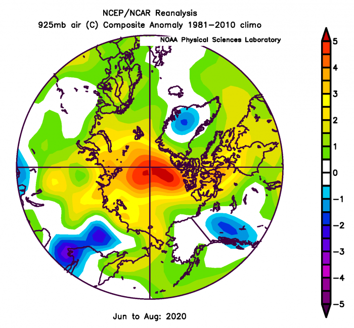
Summer (June-July-August) weather patterns generally supported sea-ice loss over the central Arctic with greater than normal near surface air temperatures, especially in areas adjacent to the Taimyr Peninsula in Siberian and Canadian high Arctic (Figure 6). The Siberian shelf began the sea-ice retreat season warm based on the winter-spring heat wave with thin coastal sea ice.
June had low sea level pressure north of the Kara Sea that advected warm air from the south originating in central Siberia; winds were from the east just north of Alaska, which opened up the sea ice north of Canada. July and August switched to high pressure on the entire Siberian side of the Arctic, allowing continued absorption of solar energy into the ocean surface. In August, a major low pressure centered near Svalbard brought a narrow band of warm air to the north of Canada. Winds north of Alaska remained weak easterly with little thermodynamic impact on sea ice. A strong late July storm (969mb at 78N, 155W 28 July) played a significant role in subsequent Chukchi and western Beaufort sea ice loss.
Section 4. Review of The 2020 Sea Ice Outlooks
Section 4a. Overview of the 2020 Sea Ice Outlook (SIO)
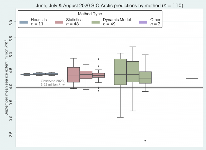
The medians of the Outlook contributions for June, July, and August were 4.33, 4.36, and 4.30 million square kilometers, respectively. The range across the monthly median Outlooks is smaller in 2020 compared to the previous three years of SIO contributions. None of the months were particularly close to the observed Sea Ice Index in terms of medians and there was little variation in the median between the three months. The outlooks were at the far end of the range of the ensemble observed extent, with the SIO medians from the three months being just below the observed ensemble maximum of 4.39 million square kilometers.
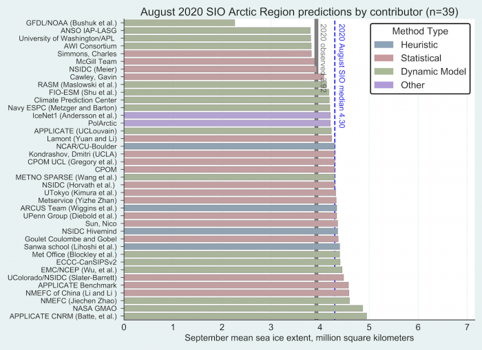
Overall, the interquartile range (IQR) of the forecasts did not vary much over the three months, with a range of 4.06 to 4.6 million square kilometers (Figure 8), so the SII observed September extent was outside the range of the forecasts throughout the Outlook period. This indicates that a shorter forecast interval was not helpful. Part of the reason for this may be the variable ice loss through the summer, with alternating periods of rapid and relatively slow ice loss (see further discussion below). In other words, the lack of a clear trend in the ice loss rates made it difficult for the Outlooks to adjust their forecasts from month to month. This is the first year since 2017 that the observed SII September extent fell outside the July IQR of the Outlook submissions of all methods (Figure 8), and the first time since 2014 that it fell substantially (>0.1 million square kilometers) outside the IQR. Using the ensemble observations, there is some overlap at the high range of the ensemble extent, but overall the distributions do not match up particularly well.
Section 4b. Review of Statistical Methods
We received a total of 48 submissions during the season (13, 17, and 19 submissions for June, July, and August respectively) for the statistical methods. The median values are 4.28, 4.33, and 4.30 million square kilometers for each month, and the means are 4.29, 4.30, and 4.26 millions square kilometers for each month, respectively. Figure 9 shows the submission from each individual group for each month through the season. Five groups (Kondrashov, Dmitri; Lamont; NSIDC (Meier); Simmons-Charles; and Sun, Nico) produced the best forecast in their August submission compared to their June or July submissions. On the other hand, three groups (APPLICATE, UPenn group, and UTokyo) have larger errors in their August submissions. Four groups (Cawley, Gavin, CPOM, McGill Team, and NMEFC of China (Li and Li)) submitted the same value of forecast in all three months, and another three groups (IceNet1, PolArctcuc, and NASA GSFC) made a single submission for the entire season.
One thing that stands out in this season is that the spread among the statistical method's contributions is quite small, especially for August SIO, compared with the dynamical models as shown above in Figure 8. The overall mean (4.28) and median (4.30) million square kilometers averaged during the season are very close. Although the spread is relatively small among each individual group, the overall contributions over-forecasted the September sea ice extent by 0.36–0.38 million square kilometers.

Out of the 20 submissions based on statistical methods, three—CU/NSIDC; Lamont (Yuan and Li); and Sun, Nico—also provided a spatial sea-ice probability forecast, their contribution is summarized in the following section, together with other dynamical models.
Statistical methods included linear models, nonlinear models, and one probability model. Statistical models have two characteristics that are fundamentally different from dynamic models. First, they can be developed with a single time series of sea-ice extent without requiring the spatial information of ice concentration. Second, they rely on statistical relationships that can be built using monthly time series. These two characteristics give statistical models tremendous advantage in terms of computing resource demands, compared to dynamic models. Compared to predictions from other methods submitted to our monthly SIO in 2020, the forecasted September sea-ice extent from these statistical models actually had the least spread in all three months—a similar conclusion found from our 2019 SIO season.
Section 4c. Review of Dynamical Models and Methods of Forecast Initialization
The mean September sea-ice extent forecast from all dynamical models was 4.31±0.62 million square kilometers. As shown in Figure 8 above, forecasted September extents decreased slightly from June to August (mean dynamical model forecasts of 4.44±0.70, 4.35±0.56, and 4.16±0.61 million square kilometers in June, July, and August respectively), thus the model-mean forecast improved with shorter lead time (observed extent = 3.92), yet the model forecast spread (quantified by the standard deviation) was unchanged throughout the summer (i.e., forecasts did not converge with shortening lead time as one would expect). As we did last year, we assess the SIO forecasts from dynamical models based on their forecast initialization of sea-ice concentration and sea-ice thickness observations. Figure 10 shows the September sea-ice extent forecasts through the summer from the models grouped by initialization: models that do not directly assimilate either extent or thickness, models that only assimilate concentration, and models that assimilate both concentration and thickness.
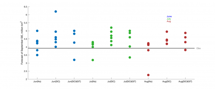
In general, models that did not assimilate either SIC or SIT forecast slightly lower September SIE, though we note this group contains an outlier with a low forecast in July and August. The mean extent across all summer forecasts was 3.98±0.61 million square kilometers (no assimilation), 4.61±0.51 million square kilometers (SIC assimilation), and 4.32±0.60 million square kilometers (SIC and SIT assimilation).
Beginning this year, we are inviting contributors to share the SIC and SIT initial conditions of their forecasts. During the 2020 SIO, several groups submitted these fields (see 2020 SIO June, July, and August reports). Comparing fields shows that, in general, models show consistent SIC initial conditions, but large spread in SIT initial conditions.
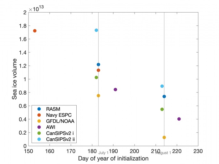
With the SIC and SIT fields, we can calculate the total sea-ice volume with which the forecasts are initialized, shown in Figure 11. This shows the large spread across models, as expected given the large spread in SIT fields. Preliminary analysis shows a relationship between sea-ice volume at initialization and September SIO, but given the small sample size further analysis is planned.
Section 4d. Spatial Forecasts of September Sea-Ice Extent Probability (SIP)
Continuing from 2014, participants were invited to submit forecasts of sea-ice extent probability (SIP – forecast probability of concentration greater than 15%). This year we received a total of 39 probability forecasts: 13 in June, 13 in July, and 13 in August. This is a record high number of SIP forecasts. Figure 12 shows the probability forecasts from June 2020, and the model mean probability forecasts for June, July, and August.
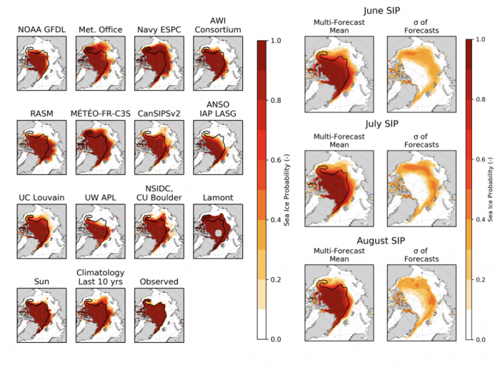
Comparing the multi-forecast SIP shows little change from June to July, and a reduction from July to August, as expected from the reduction in forecasts of SIE in Figure 8 above. Uncertainty across model forecasts shifted geographically, but was substantial in all three months, showing little convergence across different models' forecasts from June to August.
To further quantify how forecast skill evolved from June to August initializations, Figure 13 shows the spatial mean Brier scores for all model SIP forecasts and that of the model mean SIP forecast from June to August. We also include the Brier score for a climatological SIP forecast using the last 10 years as a benchmark skill forecast.
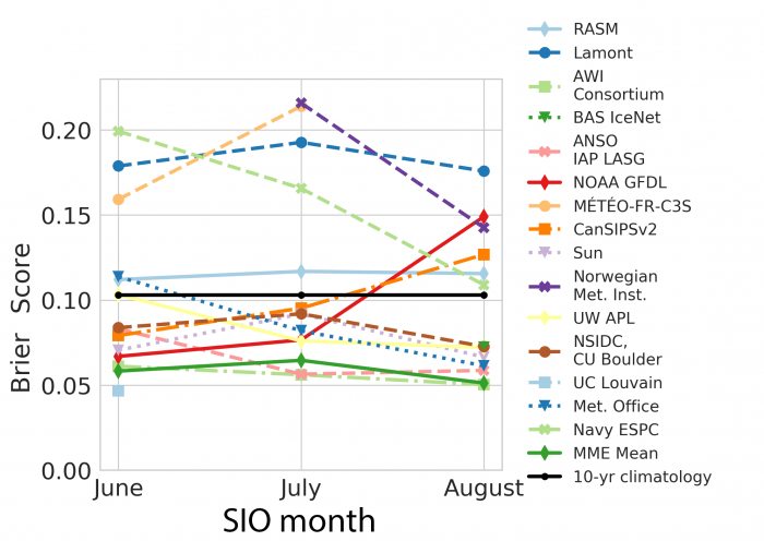
As seen in past years, there is a large spread in model Brier score, and there is overall no clear tendency for lower scores (i.e., better forecasts) from June to August, despite the shortening forecast lead time. The multi-model forecast (the forecast obtained by averaging the SIP forecasts of all models) is one of the more skilled forecasts (its skill is quantified as "MME mean" in Figure 13), a feature we have observed every year. We also note that not all models can beat a climatological forecast.
Section 4e. Review of Regional Alaska Forecasts
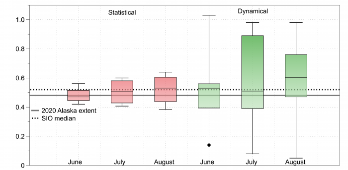
This year we again invited participants to submit forecasts of sea-ice extent for the Alaskan region, defined as the combination of the Bering, Chukchi, and Beaufort seas. We received eight forecasts in June, 10 in July, and 10 in August. Among these, 11 forecast inputs were based on statistical methods, and another 17 were based on dynamical models. The median forecasted value for the Alaskan Arctic was 0.52 million square kilometers with a standard deviation of 0.24 million square kilometers (Figure 14). The observed 2020 September extent in the Alaskan region was 0.48 million square kilometers according to NSIDC, which ranked the 10th lowest of the 42-year observational record and higher than 2019, which ranked 5th lowest at 0.36 million square kilometers.
Based on a total of 28 forecasts, the dynamic models, on average, forecast higher ice extent (0.56 million square kilometers) than the statistical models (0.50 million square kilometers), which were closer to the observed value of 0.48 million square kilometers (Figure 14). The forecasts made in August for both types of models were farther from the observed than June and July forecasts.
Section 5. Further Analysis of the Sea Ice Outlooks
Section 5a. Evaluation of 2020 SIO Forecast Skill Relative to Control Forecasts
Key metrics of the skill of the SIO forecasts are the improvement (or reduction of error) relative to control forecasts. As in weather and climate forecasting, persistence (a prediction of the same ice extent as the preceding September) is a natural control forecast. Given the strong trend of September ice extent in recent decades, additional control forecasts are the simple extrapolations of the linear trend or other representation of the trend of the historical time series. Another control forecast is the trend-line anomaly persistence, which is a forecast that the departure from the trend line will be the same as the preceding September. Below is a summary of the 2020 SIO forecasts relative to these control forecasts of the 2020 September mean ice extent (in million square kilometers). Here as elsewhere in our analysis, we focus on the medians of SIO contributions to minimize possible influence from outliers.
| 2020 observed | 3.92 |
| SIO June median outlook | 4.33 |
| SIO July median outlook | 4.36 |
| SIO August median outlook | 4.30 |
| Persistence | 4.36 |
| Linear trend extrapolation | 4.30 |
| Linear trend anomaly persistence | 4.38 |
It is apparent that the SIO median outlook was very similar to the control forecasts in 2020. The August median outlook slightly outperformed persistence, but the June and July median outlooks did not. The median outlooks from all three months outperformed the linear trend anomaly persistence. However, the most formidable competitor among the control forecasts was the linear trend extrapolation. The linear trend extrapolation outperformed (by a small margin) the June and July SIO median forecasts, while its forecast was the same as the SIO median in August. The main message from the preceding table is that the SIO median forecasts and the control forecasts were all in a narrow range and too high by about 0.4 million million square kilometers. It is noteworthy, however, that the control forecasts were available in October of 2019, as soon as the 2019 September ice extent was known.
Section 5b. Historical Evaluation of SIO Forecast Skill
The median July SIO forecast in 2020 was 4.36 million square kilometers, about 440,000 square kilometers higher than the observed September extent (3.92 million square kilometers). Over the SIO history, larger prediction errors have tended to occur in years when observed extent departs markedly from the previous year's extent. That was the case in 2020, when the observed extent ended up more than 400,000 million square kilometers lower than it had been in 2019. Figure 15 illustrates how well 2020 fits this overall pattern in a plot of SIO ensemble errors (observed September extent minus median July SIO prediction) against the change in the observed extent compared with the previous year. Change from the previous year explains 85% of the variance in SIO median errors.
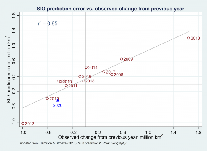
The strong correlation in Figure 15 suggests that expecting "persistence," or guessing that this year's ice extent will be the same as last year's, might yield predictions competitive with the median SIO. An alternative climatological null hypothesis could use predictions from either linear or quadratic extrapolation, representing the overall trends to that date. Table 3 compares the accuracy of median SIO predictions with these other strategies in terms of their root mean squared errors (MSE), or the more outlier-resistant metric of median absolute errors. By either criterion, over 2008–2020 the median of July SIO predictions performed better than guessing this year will equal the previous year's value ("persistence"), and better than extrapolating the linear or quadratic downward trend up to, but not including, each year.
The root MSE and median absolute errors shown here are in millions of square kilometers. Thus, taking the July SIO median as our prediction each year yields a median absolute error of 322,000 million square kilometers. Although lower than the median absolute errors from linear extrapolation (409,000 million square kilometers), quadratic extrapolation (456,000 million square kilometers), or persistence (420,000 million square kilometers), that still leaves much room for improvement in predicting the interannual variations of sea-ice extent.
Table 3: Comparison of median July SIO predictions with predictions based on linear or quadratic extrapolation (using data from 1979 to the previous year) or persistence (extent same as previous year), over 2008–2020, in million square kilometers.
| Prediction method | Root MSE | Median absolute error |
|---|---|---|
| SIO July median | 0.535 | 0.322 |
| Linear extrapolation | 0.591 | 0.409 |
| Quadratic extrapolation | 0.657 | 0.456 |
| Persistence | 0.637 | 0.420 |
The linear and quadratic trend extrapolations in Table 3 are "dynamic" in that the trends are updated yearly to the previous year (e.g., using 1979–2007 data to extrapolate 2008, 1979–2008 to extrapolate 2009, and so forth). If one uses a "static" trend, i.e., the same 1979–2020 trend for all years, the errors of the linear extrapolation improve slightly to 0.50 (Root MSE) and 0.32 (Mean absolute error). The corresponding error metrics of the persistence of the departure from the linear trend line are 0.64 (Root MSE) and 0.36 (Mean absolute errors). However, the use of a"static" (1979–2020) linear trend does not mimic the situation faced by SIO contributors, for whom the available information extended only through the years preceding their forecast. In this respect, Table 3 contains the error metrics of the more appropriate control forecasts.
While the errors of the control forecasts are larger than those of the July SIO outlook, it should be noted that all the control forecasts are available much earlier than the SIO outlooks. The persistence- and trend-based forecasts for the next September are available as soon as the current year's September ice extent is known. For example, the control forecast for September 2021 based on the linear trend extrapolation is 4.21 million million square kilometers. Based on the preceding results, the expected error of this forecast is only slightly larger that of the 2021 SIO outlooks.
Section 5c: Results from SIO Contributors Survey
The Sea Ice Prediction Network—Phase 2 (SIPN2) engagement efforts were directed towards enhancing our understanding of the SIO contributor community with the intent of identifying how the SIO can continue evolving as an information platform. An online survey of contributors was conducted and the findings used in support of the SIO contributor forum which was held this past January.
The survey covered three broad areas: (1) SIO contributor research association and type of forecasts submitted; (2) How the SIO is utilized and why they contribute; and (3) Suggested future changes. Twenty three contributors responded to the survey resulting in a response rate of approximately 64%.
Roughly half of respondents indicated that they were associated with academic institutions in either North America or Europe, while approximately 25% of respondents are associated with a governmental research organization. There was an even split between the utilization of statistical and dynamical forecasting methods identified by contributors. Of the 85 monthly forecasts for sea-ice extent submitted for 2020, 51 (60%) were centered on the Pan-Arctic, 18 (21%) were centered on Alaska, and the remaining 16 (19%) were oriented on the Pan-Antarctic.
Contributors were asked a series of questions about why they submit a forecast to the SIO. A total of 19 respondents answered this series of questions. Their responses are useful in helping the SIPN2 Project Team identify how the SIO is utilized by contributors. Approximately 84% of responding contributors indicated that they submit a forecast in order to compare their results against those of other contributors. Roughly 75% of contributors indicated that they submitted a forecast in order to increase the exposure of their organizations. Finally, 56% of contributors indicated that they submit a forecast to inform Arctic and Antarctic stakeholders.
The SIO contributor community includes a diverse group of researchers who come from distinct institutional backgrounds. Improving our understanding why contributors engage with the SIO provides a first step towards identifying how the SIO can evolve to better support and foster their work.
Section 6. Discussion of Metrics
The primary metric for comparison of Outlooks is the September monthly average sea-ice total extent, with the observations based on the NSIDC Sea Ice Index (SII). As noted above in section 3, there are several sources of sea-ice extent and these lead to a fairly wide spread of roughly +/-500,000 square kilometers between different products.
However, there is also the issue of how the September monthly average sea-ice total extent is calculated. One approach is to average daily gridded concentration fields to create a monthly average concentration field. Then the total extent is calculated based on summing all grid cell areas where concentration is >15%. This is the approach the Sea Ice Index used for many years and was the initial guidance provided by the Sea Ice Outlook.
Another approach is to calculate a daily total extent from each day's gridded concentration field (summing up the area where concentration is >15%). Then the monthly average total extent is calculated by simply average the total extent from all the days in the given month. The Sea Ice Index switched to this method in October 2017.
The first method has the advantage that the monthly average total extent is consistent with gridded monthly concentration and extent maps. However, the second method is deemed to be the best approach for calculating the monthly average total extent (see https://nsidc.org/sites/nsidc.org/files/files/NSIDC-special-report-19.p…). This is because the first method can result in biases and unrepresentative values.
An example illustrates this: Assume a 30 day month and a region of 100 square kilometers and that the region is covered by 100% ice for five days and then 0 % for the other 25 days of the month. In the first method, the monthly average concentration for that month would be 100% * 5 / 30 = 16.7%. Because this is >15%, it means the region would be counted ice-covered and the monthly average total extent would be 100 square kilometers. But this seems quite unrepresentative and biased when only 5 days out of the month had ice. In the second method—the one currently used by the SII—the monthly average extent would be: 100 sq km * 5 /30 = 16.7 sq km, which better represents the characteristics of the ice cover as a monthly average extent.
The difference between the two methods can be quite noticeable when there is a large change (i.e., rapid ice growth or ice loss) during a month. The largest differences typically occur in October and during some Octobers were ~1,000,000 square kilometers. The average differences in all months are ~200,000 square kilometers, and as demonstrated from the example above, the new method results in a lower monthly total extent. For September, the new method on average is ~130,000 square kilometers below the old method. The two methods and the resulting differences in SII monthly values are fully explained in an online NSIDC report here: https://nsidc.org/sites/nsidc.org/files/files/NSIDC-special-report-19.p….
Section 7: Discussion of Lessons Learned from SIO Contributors Forum
The SIO Contributors Forum was held as an online workshop 21–22 January 2021 with 70 participants (SIO Contributors and SIPN2 Leadership Team) from ten countries. The meeting comprised a mix of pre-recorded presentations, plenary and lightning talks, and several breakout group discussions. Participants shared and discussed successes and challenges in Arctic sea-ice prediction, identified future activities to improve forecasting, and recommended future collaboration and networking activities.
Plenary presentations covered a broad range of topics relevant to the SIO, including a comparison between different harmonized sea-ice extent products, a review of the role of sea-ice initial conditions in the SIO, potential lessons to be learned from the hurricane prediction community, as well as a perspective from the private sector and a meta-analysis of the more than 1000 predictions contributed to the SIO to date. Lightning talks provided brief updates and perspectives from SIO contributors. A summary of a SIO contributor survey that was circulated prior to the meeting helped guide the selection of discussion topics for breakout groups.
Key findings from the breakout group sessions include the following:
Skill metrics: Recognition of the importance of metrics beyond the mean and spread around predicted ice extent led to a discussion of other quantities such as the integrated ice-edge error. Performance metrics also need to match diverse information needs across the user spectrum that includes modelers, operational forecasters, and other stakeholders.
User needs: Discussion focused on two application areas: Arctic shipping and coastal over-ice transportation. In the shipping sector, SIO products are becoming more relevant, in particular as recently developed products such as ice probability and melt-free states have more relevance than large-scale minimum sea-ice extent. Coastal over-ice transportation requires downscaling of predictions, informed by local knowledge and measurements (with a need for greatly expanded ice thickness observations). SIPN should assemble a list of end-user needs (e.g., lead times, resolution) to be shared with modelers.
Predictability: Collaboration between statistical and dynamical forecasters was identified as an important step to increase predictive skill. Use of common metrics for evaluation, assessing how statistical relationships are represented in dynamical models, and how this information can be used to improve the dynamical model forecasts hold promise. Furthermore, determining the degree to which ice prediction skill is limited by errors in atmospheric and oceanic forcing or internal variability was seen as an important topic. In the Pacific sector, lower prediction skills than for the Atlantic sector suggest that better understanding of ocean-atmosphere interactions may increase predictability.
Initialization and data assimilation: This topic received considerable attention, recognizing in particular that the "initialization shock" associated with, e.g., atmospheric or ice thickness fields, needs to be accounted for and reduced across different dynamical model contributions. Moreover, given the uncertainties across different sea-ice concentration data sets, assimilating multiple data sets may be a better approach. The impact of assimilating better and more comprehensive ocean data, including in particular subsurface ocean conditions, is an important next step.
Enhancing SIO outputs and metrics: Recognizing the limitations of (minimum) sea-ice extent as a metric, a number of more relevant metrics were considered. These metrics include sea-ice volume forecasts, timing of ice advance or when a threshold (defined by, e.g., operational end-users) is first crossed, duration of the summer ice season, melting-day anomalies, or ice-extent anomalies.
Workshop participants identified a series of activities and refinements to enhance the SIO, including:
- Extending the forecast period, specifically adding May and September initialization dates;
- Calling for additional variables/metrics, including ice-extent anomaly and measures of ice advance timing. Details are to be determined and may benefit from a survey of prediction contributors and users. Highlighting predictions of other metrics beyond the pan-Arctic sea-ice minimum extent as the signature product of the SIO was seen as important;
- Updating and rerunning the 2016 initialization experiment with a consistent ice thickness initialization, but perturbing initial states and analyzing impact of "initialization shocks" in more detail;
- Synthesis and comparison of dynamical and statistical model forecasts in a joint publication; and
- Creation of an SIO database to facilitate meta-analysis of predictions.
Section 8. Sea Ice Forecasts for the Alaska Fishing Industry
Engagement with ship captains who are active in the Bering Sea fixed gear fishery occurred via online survey using the Qualtrics platform through the spring and early summer of 2020. Survey results were presented during the SIPN2 webinar held on 28 April 2020 (https://www.arcus.org/sipn/meetings/webinars). The fixed gear fishery consists of both crab and cod fishing operations. Fleet operations typically run through the winter and early spring with most vessels pursuing crab during the season. Therefore, members of the fishery must anticipate and be prepared for encountering sea ice.
The principal objective of the survey was to identify interest in and preferences for a seasonal sea-ice forecast for the region. The survey was administered using an online platform. Survey questions addressed respondent experience in the fishery, utilization of synoptic sea-ice forecasts, their interest in having a sea-ice forecast one month in advance of operations, and the geographic areas and months in which they could use a forecast. Fourteen ship captains shared their insights.
On average, respondents had 30 years of experience operating in the Bering Sea fixed gear fishery and most frequently pursued snow and red crab. Respondents reported checking synoptic forecasts provided by the National Weather Service at least every other day while out fishing.
Prior negative sea-ice impacts identified by vessel captains included lost gear, lost days fishing, and vessel damage. Importantly, respondents noted that the availability of a one-month sea-ice forecast would be particularly beneficial to operations. With respect to what information to convey in the forecast and which month such forecasts would be most useful, respondents noted that information on the location of sea ice was most important and that they would most benefit from forecasts made one month in advance of January. While additional engagement work is needed, the responses provide early insights into how sea-ice forecasts with longer lead time can be utilized by an economically valuable industry.
Section 9. Antarctic Contributions
Since 2017, the Sea Ice Outlook has accepted Antarctic contributions in the form of a pan-Antarctic September sea-ice extent forecast. September is the month of maximum sea-ice extent according to observations, and the climatological mean (1979–2020) for that month is 18.53 million square kilometers, according to the NSIDC G02135 Sea Ice Index. In 2020, sea-ice extent reached 18.77 million square kilometers in September, which is the 13th highest out of 42 years and 0.24 million square kilometers above climatology.
We received contributions from eight groups. Three followed a statistical approach (Lamont, Meier NSIDC, APPLICATE Benchmark) and five followed a dynamical model-based approach (UCLouvain, Navy ESPC, Wu et al., Met Office, BSC). These groups are also regular contributors to the SIPN South activity (https://fmassonn.github.io/sipn-south.github.io/), which aims at collecting austral summer Antarctic forecasts. Initial analyses conducted in the framework of SIPN South indicate that statistical contributions are, in general, performing better than dynamical models, including for metrics that take into account the spatial distribution of sea-ice concentration.
Figure 16 shows the Sea Ice Outlook forecasts for September 2020 as submitted in June, July, and August 2020, together with the historical time series from satellite observations and the observed value for 2020 (18.77 million square kilometers according to NSIDC Sea Ice Index). There are several interesting points, in particular because they were already raised over the past three years:
- The forecast ensemble range exceeds the observed historical range by about a factor of two. This was already the case in previous Sea Ice Outlook reports.
- The large range stems from the dynamical models, which both overestimate and underestimate historical record high and low September sea-ice extent.
- Regarding dynamical model contributions, a similar result was found in the SIPN South summer forecasts and this seems to be related to initialization issues and/or to systematic model biases.
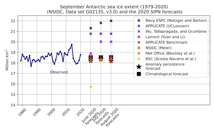
The Met Office (dynamical model) contribution provided a better forecast than other dynamical contributions and its forecast improves with shortening lead time. The other dynamical contributions either update the forecasts in the wrong direction (forecasts deteriorated with shortening lead time) or are almost stable. Note that the UCLouvain is a mere repetition of the forecast submitted in June. It is worth mentioning that not all dynamical contributions use a bias-correction scheme.
In general, similar to SIPN North findings, statistical approaches have better skill than dynamical approaches for pan-Antarctic sea-ice extent. This statement might not hold at the regional scale for this winter season (it does for summer), and needs to be verified with predictions from at least several more years.
Section 10. Sea Ice Drift Forecast Experiment (SIDFEx) Results
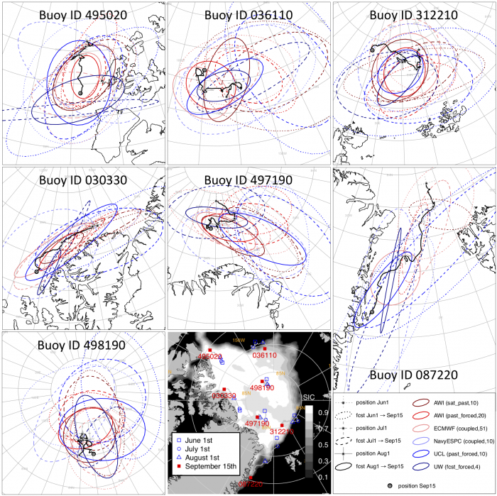
2020 was the fourth year of the Sea Ice Drift Forecast Experiment (SIDFEx), a contribution to the Year of Polar Prediction (YOPP). SIDFEx is a community effort to collect and analyze Arctic sea-ice drift forecasts at lead times from days to a year, based on various methods, for a number of buoys and other objects drifting with the ice, including the MOSAiC 2019–20 drift campaign. Here we only consider the seasonal buoy drift forecasts aligned with the 2020 Sea Ice Outlook, in continuation of the SIDFEx analysis presented in the 2018 and 2019 Sea Ice Outlook Post-Season reports.
In 2020, six of the thirteen groups contributing to SIDFEx submitted seasonal drift forecasts for Arctic buoys using model runs that were also used for the SIO contributions. Five of these used dynamical models: AWI Consortium, Navy ESPC (Metzger and Barton), ECMWF (SEAS5), APPLICATE (UCLouvain), and University of Washington/APL. The sixth (AWI sat_past) comprises ten-member ensembles based on satellite-derived drift fields of the previous 10 years; it can thus be regarded as a climatological reference forecast.
The analyses presented in previous post-season reports considered two (2017), three (2018), and six (2019) buoys; for this year 2020 we analyze forecasts for seven SIDFEx-targeted buoys that stayed in the ice cover and continuously provided data from 1 June through 15 September (Figure 17). The overall drift pattern in June, directed mainly from the Bering Strait toward Fram Strait, was stronger than usual due to lower-than-average pressure north of the Kara Sea. In contrast, the average drift in July and August was clockwise around a high pressure center located over the middle of the Arctic Ocean (See Figure 9 from the 2020 Interim Post-Season Report), driving the ice cover from the Atlantic sector toward the Beaufort Sea. Finally, low pressure centered over Franz Josef Land and Svalbard resulted in drift from the Laptev Sea towards Canada, Greenland, and the Fram Strait in September.
We depicted and evaluated the forecasts based on ellipses obtained by fitting 2D-Gaussian distributions to the forecast ensembles (Figure 17). Spatial uncertainty in the position forecasts for 15 September tends to decrease as the initial time approaches the target time for all buoys (solid ellipses are smaller than dashed and dotted ellipses). Forecast ellipses for the buoys closer to Canada and Greenland (in particular 030330 and 087220) tend to be more eccentric, with their main axis parallel to the coast, consistent with the observed drift along the coast. The forecasts are defined as "reliable" when the ellipses contain ("hit") the observed position in approximately 90% of all cases. Combining all initial dates and forecast systems, hit rates range from almost 100% (buoy 495020) to only about 30% for those buoys that have been affected by particularly anomalous drift, such as the westward drift north of Canada and Greenland in July and August (buoy 030330) and the fast southward drift in the Greenland Sea from July through September.
Interestingly, buoy 030330 was part of the MOSAiC Distributed Network, initially deployed within a 40 km radius from the icebreaker RV Polarstern. After entering Fram Strait in July, the array was scattered along the coast of Greenland (not shown) so that buoys were located up to 800 km apart by 15 September. This points to a strong role of chaotic dispersion which adds to drift uncertainties associated with limited atmospheric predictability.
Overall, hit rates are similar to those found in 2018 but lower than in 2019, when drift patterns were less anomalous. These results are consistent with the conjecture that the influence of long-lived anomalies, such as ice thickness anomalies, on ice drift is very limited based on preliminary coupled model experiment results. The predictability of ice drift may thus be barely higher than the limited predictability of its primary driver, the winds.
Report References
Banzon, Viva, Thomas M. Smith, Michael Steele, Boyin Huang, and Huai-Min Zhang. " Improved Estimation of Proxy Sea Surface Temperature in the Arctic", Journal of Atmospheric and Oceanic Technology 37, 2 (2020): 341-349, accessed at https://doi.org/10.1175/JTECH-D-19-0177.1
Maslanik, J. and J. Stroeve. 1999. Near-Real-Time DMSP SSMIS Daily Polar Gridded Sea Ice Concentrations, Version 1. Boulder, Colorado USA. NASA National Snow and Ice Data Center Distributed Active Archive Center. doi: https://doi.org/10.5067/U8C09DWVX9LM.
Sea ice concentration fields used to calculate the ensemble extents:
- Bremen ASI from AMSR2 produced by the University of Bremen and University of Hamburg: https://seaice.uni-bremen.de/sea-ice-concentration/amsre-amsr2/
- JAXA Bootstrap from AMSR2 produced by JAXA: https://suzaku.eorc.jaxa.jp/GCOM/
- MASIE produced by the US National Ice Center and distributed by NSIDC: https://nsidc.org/data/masie/
- NOAA Near-real-time Sea Ice Concentration Climate Data Record from F18 SSMIS produced by NSIDC: https://nsidc.org/data/g10016
- NSIDC Near-real-time NASA Team from F18 SSMIS produced by the NASA Snow and Ice DAAC at NSIDC: https://nsidc.org/data/nsidc-0081
- NASA Team 2 from AMSR2 produced by NASA and distributed by the NASA Snow and Ice DAAC at NSIDC: https://nsidc.org/data/AU_SI12/versions/1
- OSI SAF 401-b from F16, F17, and F18 SSMIS produced by EUMETSAT OSI SAF: http://osisaf.met.no
- OSI SAF 408 from AMSR2 produced by EUMETSAT OSI SAF: http://osisaf.met.no
Report Acronyms
AMSR2 = Advanced Microwave Scanning Radiometer 2 on the JAXA GCOM-W platform
ARTIST = Arctic Radiation and Turbulence Interaction STudy
ASI = ARTIST Sea Ice
EUMETSAT = European Meteorological Satellite Program
F18 = U.S. Defense Meteorological Satellite Program (DMSP) F18 satellite
GCOM-W = Global Change Observation Mission - Water satellite
JAXA = Japanese Aerospace eXploration Agency
MASIE = Multisensor Analyzed Sea Ice Extent
OSI SAF = Ocean and Sea Ice Satellite Application Facility
SSMIS = Special Sensor Microwave Imager and Sounder
Report Credits
This 2020 Sea Ice Outlook Full Post-Season Report was developed by the SIPN2 Leadership Team with contributions from several of our partners and collaborators.
Report Lead:
Uma Bhatt, University of Alaska Fairbanks, Geophysical Institute
Additional Contributors:
Peter Bieniek, University of Alaska Fairbanks, International Arctic Research Center
Cecilia Bitz, University of Washington, Program on Climate Change
Edward Blanchard-Wrigglesworth, University of Washington, Department of Atmospheric Sciences
Hajo Eicken, University of Alaska Fairbanks, International Arctic Research Center
Helge Goessling, Alfred-Wegener Institute, Helmholtz Centre for Polar and Marine Research
Larry Hamilton, University of New Hampshire, Carsey School of Public Policy
Joseph Little, University of Alaska Fairbanks, School of Management
François Massonnet, Université Catholique de Louvain (Belgium)
Walt Meier, National Snow and Ice Data Center
James Overland, NOAA, Pacific Marine Environmental Laboratory
Mark Serreze, University of Colorado Boulder, NSIDC
Michael Steele, University of Washington, Applied Physics Laboratory
Julienne Stroeve, University College London, National Snow and Ice Data Center
Rick Thoman, University of Alaska Fairbanks
Molly Hardman, National Snow and Ice Data Center
John Walsh, International Arctic Research Center, University of Alaska Fairbanks
Muyin Wang, NOAA and the Joint Institute for the Study of the Atmosphere at the University of Washington
Helen Wiggins, Arctic Research Consortium of the U.S. (ARCUS)
Editors:
Betsy Turner-Bogren, ARCUS
Helen Wiggins ARCUS
Lisa Sheffield Guy, ARCUS
Stacey Stoudt, ARCUS
Suggested Citation:
Meier, W., U. S. Bhatt, J. Walsh, R. Thoman, P. Bieniek, C. M. Bitz, E. Blanchard-Wrigglesworth, H. Eicken, L. C. Hamilton, M. Hardman, E. Hunke, T. Jung, J. Kurths, J. Little, F. Massonnet, J. E. Overland, M. Serreze, M. Steele, J. Stroeve, M. Wang, and H. V. Wiggins. Editors: Turner-Bogren, B., L. Sheffield Guy, and S. Staudt. March 2021. "2020 Sea Ice Outlook Post-Season Report."
This Sea Ice Outlook Report is a product of the Sea Ice Prediction Network–Phase 2 (SIPN2), which is supported in part by the National Science Foundation under Grant No. OPP-1748308. Any opinions, findings, and conclusions or recommendations expressed in this material are those of the author(s) and do not necessarily reflect the views of the National Science Foundation.
