July Call for Sea Ice Outlook Contributions
July Report (Based on May and June data)
Submission deadline: 6:00 p.m. (AKDT) Thursday, 13 July 2017 (firm)
Please follow NEW SUBMISSION PROCESS guidelines, detailed below.
Questions can be directed to: Betsy Turner-Bogren, betsy [at] arcus.org
Overview
The Sea Ice Prediction Network (SIPN) announces the call for contributions for the 2017 Sea Ice Outlook July report. The Sea Ice Outlook provides an open process for those interested in Arctic sea ice to share ideas. The monthly reports contain a variety of perspectives—from advanced numerical models to qualitative perspectives from citizen scientists. A post-season report will provide an in-depth analysis of factors driving sea ice this summer as well as explore the scientific methods for predicting seasonal conditions.
Pan-Arctic and Alaska Regional Sea Ice Extent Outlooks and any additional figures and gridded fields will be accepted for the 2017 July Outlook. We particularly encourage submissions for the Alaska region (i.e., Bering, Chukchi, and Beaufort seas). Submissions that include spatial forecast maps are also encouraged. Starting in 2017 the SIO will also accept pan-Antarctic sea ice extent of the September monthly mean.
Detailed guidelines for contributions are below. We encourage all past contributors to submit Outlooks this year and we also hope to see new participants. Sea Ice Outlook data resources are available via the National Snow and Ice Data Center (NSIDC) SIPN Data Set webpage: http://nsidc.org/data/sipn/data-sets.html.
In addition to the contributions for the monthly reports, we are also accepting "informal contributions" throughout the season that do not otherwise fit into the monthly report format. These informal contributions could include information on fall freeze-up data, sea ice observations, and parameters other than extent and/or for other time periods than what is included in the regular monthly reports. Informal contributions should be sent via email to sio2017 [at] arcus.org.
The 2017 Sea Ice Outlook represents a transition year, as current grant funding for SIPN is coming to a close and we are pursuing proposals to further develop and expand SIPN. We will focus only on the Sea Ice Outlook for this summer and fall.
SUBMISSION DEADLINE: 6:00 pm (AKDT) Thursday, 13 July 2017 (firm). Contributions received after the deadline will not be incorporated into the Outlook report or discussion.
Questions may be directed to Betsy Turner-Bogren, ARCUS (betsy [at] arcus.org)
New Submission Process
Required and core information will be collected on a Google-based form found here. Submissions of more detailed Outlooks reports, including discussions of uncertainties, probabilities, relevant figures, references, and submissions of gridded data or full spatial fields will be accepted via Dropbox.
If you did not receive the link to Dropbox, please contact Betsy Turner-Bogren (betsy [at] arcus.org).
Note: If either the Google form or Dropbox are not workable options, files may be sent via email to: sio2017 [at] arcus.org.
I) Core Information will be collected on a Google form. After submitting the form, you’ll receive a link to your answers that you can use in future months. Contributors will only have to enter most of the fields once this year!
II) Contributors have the option of submitting a more detailed Outlook report, including discussions of uncertainties/probabilities, including any relevant figures, imagery, and references. Please upload this information via the Dropbox link sent to you via email.
III) If you are able to send gridded data or figures of full spatial fields, see instructions below. Please also upload this information via the same Dropbox link, sent to you via email. Note that this year we are also requesting initial condition fields.
Note: For those who are unable to use google forms or the Dropbox link, email contributions will be accepted. Send contributions to to sio2017 [at] arcus.org.
Submission Fields in Google Form
For your information, below are the fields on the SIO 2017 google form.
Responses to questions 1-6 are required, as indicated with an asterisk * Response to question 7 is required if sea ice concentration is used.
What is the type of your Outlook projection? *
Check box for: Dynamic Model, Statistical, Heuristic, Mixed, Other
Starting in 2017 we are accepting both pan-Arctic and pan-Antarctic sea ice extent (either one or both) of the September monthly mean. As in 2016, we are also collecting Alaskan regional sea ice extent. To be consistent with the validating sea ice extent index from NSIDC, if possible, please first compute the average sea ice concentration for the month and then compute the extent as the sum of cell areas > 15%.
a) Pan-Arctic September extent prediction in million square kilometers.
b) same as in (a) but for pan-Antarctic. If your method differs substantially from that for the Arctic, please enter it as a separate submission.
c) same as in (b) but for the Alaskan region. Please also tell us maximum possible extent if every ocean cell in your region were ice covered. See below for detailed instructions.
Name of contributor or name of contributing organization (this is how we'll label your contribution in the report, see a past report for examples such as http://www.arcus.org/sipn/sea-ice-outlook/2016/june/)*
Name and organization for all contributors. Indicate primary contact and total number of people who may have contributed to your Outlook, even if not included on the author list. *
If this a contribution from a person or group not affiliated with a research organization please check this box:
_____Yes, this contribution is from a "Citizen Scientist."Do you want your June contribution to automatically be included in subsequent reports? (If yes, you may still update your contribution via the Google form.) *
____ Yes, automatically include my contributions in July and August 2017.
____ No, do not use my prediction this month in later months."Executive summary" of your Outlook contribution (using 300 words or less) describe how and why your contribution was formulated. To the extent possible, use non-technical language. *
Brief explanation of Outlook method (using 300 words or less). *
Dataset of initial Sea Ice Concentration (SIC) used (include name and date; e.g., “NASA Team, May 2017”). We also encourage you to submit initial fields to the dropbox, see https://www.arcus.org/sipn/sea-ice-outlook/2017/june/call in the section on "Submitting Figures and Gridded Data of Full Spatial Fields (Optional) of Forecasts and Initial Conditions" for detailed instructions.
Response to questions 8-10 are optional, but answers are encouraged.
Dataset of initial Sea Ice Thickness (SIT) used (include name and date):
If you use a dynamic model, please specify the name of the model as a whole and each component including version numbers and how the component is initialized:
For Example:
    Component      Name        Initialization (e.g., describe Data Assimilation)
    Atmosphere     CAM5        2016 RCP8.5 integration
    Ocean          NEMO2       DA - NCODA system
    Ice            TED         DA - EnKF SIC only
If available from your method:
a) Uncertainty/probability estimate such as median, ranges, and/or standard deviations (specify what you are providing).
b) Brief explanation/assessment of basis for the uncertainty estimate (1-2 sentences).
c) Brief description of any post processing you have done (1-2 sentences).
Instructions for Submitting an Alaskan Regional Outlook (Optional, yet encouraged)
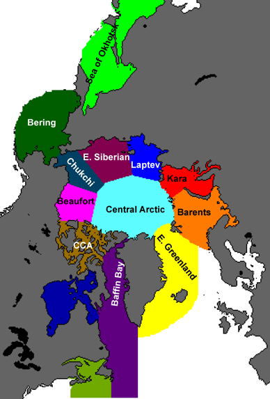
Please submit a total extent for the Alaskan region, defined here as the combination of the Bering, Chukchi, and Beaufort seas. If possible use the definition from the NSIDC Arctic sea ice regional graphs and time series from the mask below, which is on the 25km by 25km polar stereographic projection used for the passive microwave satellite data. For questions about the format or this request, please contact Muyin Wang (muyin.wang [at] noaa.gov).
The mask is provided as a netcdf file here ![]() NSIDC Regional Mask (NC - 2 MB).
NSIDC Regional Mask (NC - 2 MB).
Please enter your submission into the Google form item 2c. Also tell us the maximum possible ice extent if every ocean cell in your region were ice covered. For example, if your model uses exactly the same grid as the satellite data, the area would be 4.00x10⁶ km2. The maximum possible extent is probably much larger than your actual Alaskan Regional Outlook. Be sure to exclude land and islands. Finally, with your entry to item 2c, please include how you defined the Alaskan region: either say NSIDC definition, or if you must use your own definition, describe it.

Submitting Figures and Gridded Data of Full Spatial Fields (Optional) of Forecasts and Initial Conditions
These are optional but strongly encouraged for all participants whose methods provide information at the local scale. If you cannot contribute now, please read on anyway so you can take steps to provide the information in the future.
Please contact Edward Blanchard-Wrigglesworth via email (ed [at] atmos.uw.edu) for questions. But submit your figures and/or data via the Dropbox link sent by email. Feel free to zip or tar them up first.
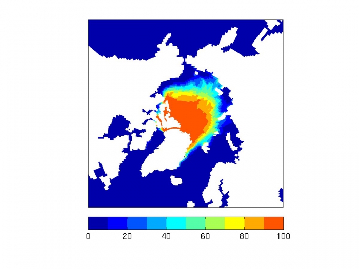
Provide a spatial forecast map for September mean ice extent (e.g., jpg, tiff, pdf). If your method predicts sea ice extent (SIE) directly, average it in time and across ensemble members, if you have them, for September (giving values between 0 and 100% inclusive). If your method predicts sea ice concentration (SIC) directly, please average it in time to make a monthly mean SIC, then convert it to SIE (grid cells with SIC<15% are assigned SIE=0% and SIC>=15% are assigned SIE=100%). Finally, average across ensemble members, if you have them. We refer to this field as a sea ice probability (SIP).

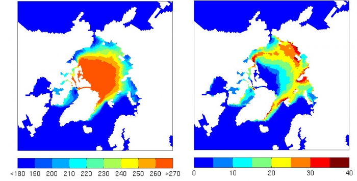
Sample of SIP (i.e., ensemble mean SIE) in percent for a random year from CESM1.1. Provide a spatial map of the first ice-free date (IFD; Julian Day when SIC<15% or SIE=0%) in 2015. Ideally the date is derived from daily frequency output of SIC. For IFD, identify ocean (SIC<15% upon initialization) with the Julian day of the start date (July 1 is day 182) and ice points that always have SIC>15% with the end date (Sep 31 is day 273). Also provide a map of one standard deviation across ensemble members, if you have them.

Sample of IFD (first ice free date as Julian Day) ensemble mean (left) and std dev (right) for a random year from CESM1.1. Use the following naming convention for filenames (for example if your surname is Smith) and you are forecasting September 2017 using June initial data:
Smith_Sep2016_Junedata_SIP.jpg
Smith_Sep2016_Junedata_IFD.jpg
Smith_Sep2016_Junedata_stdIFD.jpg
Smith_Sep2016_Junedata_README.txt (explaining how you computed SIP and IFD, follow link for an example)Provide your data for SIP and IFD (see maps in #1 and #2 above) in a format with geographic information included or in NetCDF, if possible. We will work with the format provided as long as all relevant grid/projection/data format information is provided.
a) Provide the data on your native grid and, if possible, on a common 1-degree grid.
b) Include latitude (lat) and longitude (lon) grid information in degrees, and for your native grid, include gridcell area (areacello) in square meters. For SIP and IFD, identify land points in your data field with the identifier -999. Include the std. dev. of IFD (stdIFD) in the same file with IFD.
Note: If you must submit text, please use a column format in the order: lat, lon, areacello (for the file that is on your native grid), and finally the data field. Separate columns with spaces (preferred), commas, or tabs. Do not include any information such as variables names at the beginning. Provide that information in a separate metadata file with all the information needed to understand the file.
c) For the common grid, please include latitudes 60N, 61N, 62N … 89N and longitudes 180W, 179W, … 179E (or 0 to 360E). No need to include areacello for the common grid.
d) If you provide NetCDF files use the following naming convention (or as necessary for an equivalent set of GeoTIFF files).
Smith_Sep2016_Junedata_SIP_native.nc
Smith_Sep2016_Junedata_IFD_native.nc
Smith_Sep2016_Junedata_SIP_common.nc
Smith_Sep2016_Junedata_IFD_common.nce) Or if you must use text, please provide all of the following files:
Smith_Sep2016_Junedata_SIP_native.txt
Smith_Sep2016_Junedata_SIP_native_meta.txt
Smith_Sep2016_Junedata_IFD_native.txt
Smith_Sep2016_Junedata_IFD_native_meta.txt
Smith_Sep2016_Junedata_SIP_common.txt
Smith_Sep2016_Junedata_SIP_common_meta.txt
Smith_Sep2016_Junedata_IFD_common.txtProvide your data for your forecast’s initial conditions of SIC and SIT in the same format as those in section 3 above (native and if possible common grid, netcdf preferable). Please indicate that it is an initial field in the title, such as Smith_Sep2016_JuneIC_native.nc.
For questions, please contact Edward Blanchard-Wrigglesworth via email (ed [at] atmos.uw.edu).
Associated Effort
This year’s SIO season also marks the start of the Sea Ice Drift Forecast Experiment (SIDFEx, 2017-2020), which is a community effort to collect and analyze Arctic sea ice drift forecasts at lead times from days to a year based on arbitrary methods for a number of sea-ice buoys and, ultimately, the research icebreaker Polarstern. SIDFEx is aligned with the SIO such that modelling groups contributing to the Sea Ice Outlook can contribute to SIDFEx relatively easily by computing trajectories for Lagrangian tracers.
For details, please go to: http://www.polarprediction.net/yopp-activities/sidfex/.
Tentative Schedule for Sea Ice Outlook 2017 Reports
JUNE REPORT: (Based on May data)
- 26 May 2017 (Friday): Call for Contributions for June Report
- 12 June 2017 (Monday): Contributions Due for June Report
- 30 June 2017 (Friday): June Report Released
JULY REPORT: (Based on May and June data)
- 7 July 2017 (Friday): Call for Contributions for July Report
- 13 July 2017 (Thursday): Contributions Due for July Report
- 24 July 2017 (Monday): July Report Released
AUGUST REPORT: (Based on May, June, and July data)
- 28 July 2017 (Friday): Call for Contributions for August Report
- 11 August (Friday) 2017: Contributions Due for August Report
- 23 August (Wednesday) 2017: August Report Released
POST-SEASON REPORT
- Developed during September-November 2017
Note: A call for nominations for a post-season SIO Action Team will be
circulated in early September via the SIPN mailing list:
http://www.arcus.org/sipn/mailing-list

