The May Sea Ice Outlook report for the September 2008 sea ice extent is based on a synthesis of 19 individual outlooks from the international arctic science community. The outlook for the pan-arctic sea ice extent in September 2008 indicates a continuation of the recent trend of sea ice loss.

Of the individual responses that included quantitative outlooks, three (3) suggest a return toward the long-term trend of summer sea ice loss; six (6) anticipate the 2008 extent to be close to the 2007 record minimum; five (5) respondents suggest additional ice loss compared to the 2007 minimum. None suggested a return to the historical average (mean 1979–2000 September values) of 7.0 million square kilometers.
Current State of Arctic Sea Ice from NSIDC
Daily ice extents in May continued to be below the long-term average and approached the low levels seen at this time last year. Learn more about current ice conditions here.
Background
Based on recommendations from an international workshop organized under the auspices of the U.S. SEARCH and the European DAMOCLES programs, a community-wide Arctic Sea Ice Outlook for September 2008 has been initiated to advance understanding of the arctic sea ice system, given the drastic and unexpected sea ice decline witnessed in 2007.
Sea ice extent for September 2007 was 4.3 million square kilometers—a reduction of more than 40% from the 1980s and a rapid decline to more than 20% below the previous record minimum. These are radical changes that require increased communication within the arctic science community to advance timely understanding of the arctic sea ice system. Further information on the September 2007 sea ice minimum can be found through NSIDC's Sea Ice News & Analysis website.
The goal of the Sea Ice Outlook effort is to synthesize and integrate different observation and modeling efforts and to provide a broad-based assessment of arctic sea ice change. Comments and participation are welcome from the broader research community and interested public. The Sea Ice Outlook will be updated monthly throughout the summer.
Status
The May Sea Ice Outlook report is based on 19 individual outlook reponses contributed by the international research community (using May data), as well as suggestions and guidance on presentation of the results. The May report is the first montly outlook produced through this effort. Based on input and suggestions made through the online community forum and other means, future outlook reports may include expanded analaysis and formatting (e.g., a summary of individual outlooks by methodology).
Disclaimer
The Sea Ice Outlook is not a formal consensus forecast or prediction for arctic sea ice extent, nor is it intended as a replacement for existing efforts or centers with operational responsibility. Formal prediction must rigorously address issues of uncertainty, skill, and methodology and such predictions are generally stated in terms of probabilities. Although some of the contributions to this Sea Ice Outlook are based on these methods, such a formal prediction approach is beyond the scope of this effort and is not appropriate for this Outlook.
Approach
The approach to the Sea Ice Outlook is a modified Delphi Method (i.e., using questionnaire responses from a panel of indendent experts) that: (1) samples independent expert opinion and rationale on an issue, (2) communicates the results, and (3) iterates on the process with feedback from the expert participants. We deviate from the formal Delphi Method in that the respondents here are self-selected and are not anonymous. Scientifically, the Sea Ice Outlook provides a focus for researchers to evaluate their understanding of the state of arctic sea ice, and for the community to jointly assess a range of factors that contribute to arctic summer sea ice minima.
Results
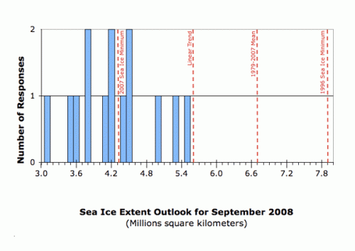
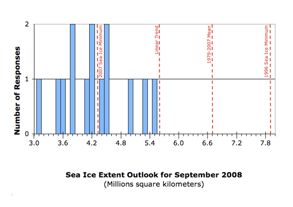
With 19 total responses, 14 provided a value for the arctic sea ice minimum extent for September 2008; 6 provided regional outlooks. The individual responses were based on a range of methods: statistical, numerical models, comparison with previous observations and rates of ice loss, or composites of several approaches; details can be found in the individual outlooks available at the bottom of this page. The distribution of the responses for how much sea ice will remain in September 2008 is:

Three (3) respondents suggest a return toward the long term trend line of summer sea ice loss. Six (6) respondents anticipate the 2008 extent to be close to the 2007 record minimum. Five (5) respondents suggest additional ice loss compared to the 2007 minimum. None suggested a return to mean 1979–2000 September values of 7.0 million square kilometers.
Compared to the 1979–2000 climatology, many respondents suggested a general repeat of 2007 for 2008 in terms of September sea ice extent; however, their reasoning for 2008 differs from the 2007 event. At the workshop and from recent publications, there is near consensus that the 2007 sea ice minimum was due to the combination of almost two decades of preconditioning (thinning and increased ice export) plus a rare supportive weather pattern in summer 2007. Some respondents note that atmospheric circulation played a role in 2007, but that it is not probable that such an unusual wind pattern will repeat itself in 2008. Many respondents point to initial conditions for 2008: less multiyear sea ice in March 2008 compared to 2007, a potentially faster rate of melting in summer in 2008. The range of respondents' estimates from 3.1 to 5.5 million square kilometers for September 2008 primarily reflects the relative importance that was given to these two factors.
The following section lists the contributors, their September 2008 outlook (in million square kilometers), and extracts key statements that comment on methods and data sources. The responses are divided into three groups: more than the sea ice extent than September 2007, about the same sea ice extent, and below the sea ice extent of September 2007. The number in brackets at the end of each statement provides a link to their full narration. Note that these outlooks were provided as a method for a semi-quantitative synthesis, and do not imply that sea ice extent can be forecast to this accuracy.
Key Statements From Individual Outlooks
More than the 2007 Sea Ice Minimum Extent:
Stern, 5.5. I believe it's important to include an estimate based on linear persistence. The degree to which this estimate is wrong is a measure of the degree to which the sea ice extent is not following a linear trend.
Bitz, 5.3. The 29 year observational record of September sea ice extent has zero autocorrelation, zero skew, and zero correlation with the [prior] May extent. These statistics are in general agreement with much longer records that are available from the Community Climate System Model version 3, CCSM3. Therefore, I have extrapolated the trend line for September sea ice extent to 2008.
Kwok, 5.0. Even though the seasonal ice cover was formed later in the fall of 2007, the mean thickness of the FY ice cover at the end of March seems comparable to that of the previous two seasons because of lower snow accumulation and thus faster growth i.e., higher ice production. The higher latitude seasonal ice cover is also thicker and regions with typically shorter melt seasons can be expected to have a better chance of surviving the summer.
About the Same as the 2007 Sea Ice Minimum Extent:
Lindsay, 4.5. The prediction is made from an ice/ocean model estimate of the state of the system at the end of April 2008. The model field in April that is best correlated with the pan-Arctic ice extent in September over the last 20 years is the area of ice and water less than 2 m thick (what we call the G2 field). The field of G2 for 2008 would predict a very low ice extent in September but the prediction is not as low as the prediction for 2007 and is much above the observed extent for 2007.
Zhang, 4.5. We would like to participate in the 2008 September arctic sea ice outlooks by conducting ensemble predictions [with a sea ice model]. The ensemble consists of seven members which use NCEP/NCAR atmospheric forcing fields from 2001-2007. The prediction starts on May 1, 2008.
Pokrovsky from Russia, 4.4 Inferred. Atmospheric circulations in March-April in Pacific sector of Arctic were substantially different between 2007 and 2008. Surface water salinity in Pacific sector of Arctic was lower in last autumn than in previous year. Actually, arctic ice in Pacific sector is rather thin now. The SAT field of 2008 April has lower positive anomaly in domain of Chukchi and Bering seas. Meanwhile, much stronger SAT positive anomaly was occurred in past year corresponding field over Kara Sea and Eastern Siberia.
Prinsenberg, 4.2. From what I saw in the Amunsdsen Gulf and imagery I feel we will have the same extent as last year "as a rebound" but then lose a lot more the following year. And the NW Passage to me will be passable. Low ice concentration should exist from now on in as no heavy Arctic pack ice is available at the entrance to M'Clure Strait to fill it after the summer.
Barber, 4.2. The remnant MY[multi-year] sea ice had a lot of new snow on it in the late fall of 2007.The MY pack was dispersed in the late fall. This caused thin first-year sea ice to grow between MY floes thereby decreasing the overall albedo of this surface in the Spring of 2008. The MY pack ice was much more mobile that in other years due to the lack of sufficiently thick ice to slow down dynamic processes.
Stabeno, 4.1. Initial conditions support a lower ice year than 2007.There will be little or no assistance with ice melt by warmer water from the Bering Sea as apparently occurred when the Bering Sea was very warm (2001-2005). The probability of the atmosphere setting up as perfectly as it did last year is unlikely.
Less Than the 2007 Sea Ice Minimum Extent:
Maslanik, Drobot, Fowler, 3.8. The forecast is based on ice age, sea ice concentration, 925hPa temperatures, and the Arctic Oscillation Index. We use a multiple regression framework. In addition a qualitative assessment is factored into our overall view. We tend to provide probabilistic forecasts only, and we're really not keen on giving a single number.
Miles, 3.8. While the winter/spring 2008 sea-ice extent has rebounded from the 2007 negative mega-anomaly, the age-class distribution at present is negatively skewed compared to satellite climatology and even the values for 2007, as is ice concentration within the ice -ocean margin that defines extent. Therefore, preconditioning would favor a less-extensive summer minimum ice cover than in 2007, unless offset by a return to atmospheric conditions that are opposite the anomalous ones in 2007.
Kaleschke, 3.6. A neural network approach was used to predict the September sea ice extent by the use of two state variables, the surface air temperature of the northern hemisphere from NCEP reanalysis and the September sea ice extent of the previous year.
Stroeve, Serreze, Meier, 3.5. This estimate is based on survival rates for ice of different age classes through the summer. Specifically, the estimate is calculated by multiplying the average (for the period 1985-2007) amount of ice that does not survive the summer (between the March maximum and the September minimum) by this year's March extent.
Rigor, 3.1. High Arctic Oscillation (AO) conditions during winter precondition summer sea ice for extensive retreats. High AO conditions were observed during the winter of 2006/2007 and again this past winter of 2007/2008. The area of MY sea ice over the Arctic Ocean has dropped another 1 million sq. km. from March 2007 to March 2008. The expected minimum is based on typical survival rates of FY and MY ice from 1956 - 2007.
One respondent suggested that the task was too difficult, but discusses factors that are important to consider: a temporal return to previous conditions or stabilization at the current level cannot be excluded just as further decline, depending on the atmospheric conditions in summer 2008, which unfortunately we are not able to predict.
Regional Outlooks
Please see Eicken for a regional perspective on sea ice evolution in the Pacific Arctic sector. An outlook for the Northwest Passage is provided by Howell and Duguay , and for the Northern Sea Route by Pokrovsky . Barber discusses the eastern Beaufort Sea and Haas the region north of Ellesmere Island. Arbetter notes that the North American Ice Service (US National Ice Center and Canadian Ice Services) has just released their seasonal outlook for the Arctic 2008.
Conclusion
Thank you for your participation, see you next month! We hope that you will take into consideration the information that your colleagues have provided, along with new data and model runs to provide an outlook near the end of June. New participants are welcome!
Core Integration Group
Jim Overland, Cecilia Bitz, Ralf Doescher, Hajo Eicken, Ron Kwok, James Maslanik, Martin Miles, Leif Pedersen, Ignatius Rigor, Julienne Stroeve
| Attachment | Size |
|---|---|
| Download All Individual May 2008 Outlook Submissions (PDF - 2.3MB)2.33 MB | 2.33 MB |
| Attachment | Size |
|---|---|
| Arbetter797.66 KB | 797.66 KB |
| Barber5.32 MB | 5.32 MB |
| Bitz26.14 KB | 26.14 KB |
| Dethloff44.95 KB | 44.95 KB |
| Eicken361.74 KB | 361.74 KB |
| Haas147.81 KB | 147.81 KB |
| Howell225.17 KB | 225.17 KB |
| Kaleschke177.61 KB | 177.61 KB |
| Kwok292.54 KB | 292.54 KB |
| Lindsay30.14 KB | 30.14 KB |
| Maslanik et al.17.54 KB | 17.54 KB |
| Meier et al.28.96 KB | 28.96 KB |
| Pokrovsky242.86 KB | 242.86 KB |
| Prinsenberg28.99 KB | 28.99 KB |
| Rigor868.05 KB | 868.05 KB |
| Stabeno22.82 KB | 22.82 KB |
| Stern33.69 KB | 33.69 KB |
| Zhang217.65 KB | 217.65 KB |
| Miles42.13 KB | 42.13 KB |


