Summary
The outlook for the pan-arctic sea ice extent in September 2008, based on July data, indicates a continuation of dramatic arctic sea ice loss. The July Sea Ice Outlook report is based on a synthesis of 22 individual projections utilizing a range of methods. Projections based on July data show no indication that a return to historical sea ice extent will occur this year.
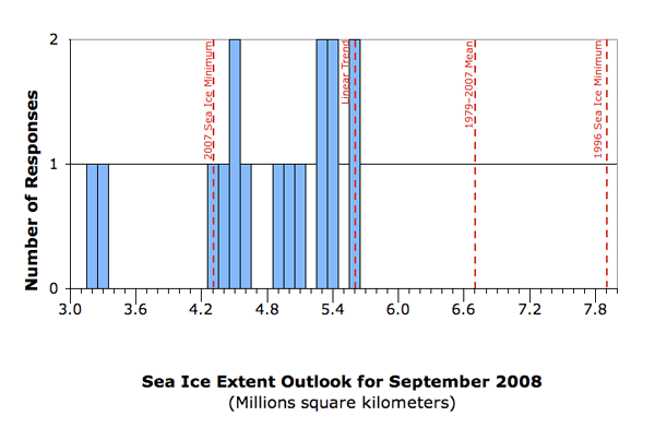
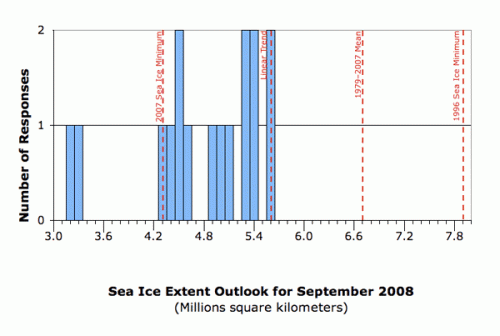
The range of responses was from 3.2 to 5.6 million square kilometers. Of the 22 contributions, 16 gave numerical values for the pan-arctic sea ice extent (see figure below). All estimates are well below the 1979–2007 September climatological mean value of 6.7 million square kilometers.
Eight (8) respondents suggest a return toward the long-term trend line of summer sea ice loss (pre-2007 long-term trend of approximately 10% loss per decade),
Six (6) respondents anticipate the 2008 extent to be close to the 2007 record sea ice minimum (i.e., 4.3 million square kilometers); and
Two (2) respondents suggest additional ice loss compared to 2007, which would set a new record minimum.
The remainder of the responses were for regional trends or did not provide a numerical value. All individual responses can be found at the bottom of the full report.
Although July data indicated that the sea ice might be on track for a slight recovery from 2007 (though still well below "normal" climatological conditions), new sea ice data and weather forecasts show that total ice extent in early August declined at about twice the rate of any other time this summer. Also of note is new data showing large regions of low sea ice concentrations within the boundary of sea ice extent at the end of July. These conditions might suggest a faster decline through the rest of the melt season.
FULL REPORT
Status
On 1 August 2008 a request was issued to the arctic research community for the July 2008 Outlook Report to update the May and June Outlooks using July data. Participants were asked to estimate the average arctic sea ice extent for the month of September 2008. Responses were obtained with a 5 August cutoff date. The July Sea Ice Outlook report is based on 22 individual responses contributed by the international research community, with a new outlook from a Japanese group. Additional background material about the Outlook effort can be found on the overview page at http://www.arcus.org/search/seaiceoutlook/index.php.
Approach and Disclaimer
The Sea Ice Outlook provides a forum for researchers to evaluate their understanding of the state of arctic sea ice and for the community to jointly assess a range of factors that contribute to arctic summer sea ice minima. The Sea Ice Outlook is not a formal consensus forecast or prediction for arctic sea ice extent, nor is it intended as a replacement for existing efforts or centers with operational responsibility.
Results
With 22 total responses, 16 provided a value for the arctic sea ice minimum extent for September 2008; 5 provided regional outlooks. Extent here is defined as the total area of ice with concentration (over an area of at least 100 square kilometers) greater than 15%. The individual responses were based on a range of methods: statistical, numerical models, comparison with previous observations and rates of ice loss, or composites of several approaches; details can be found in the individual outlooks available at the end of this report. The distribution of the responses for how much sea ice will remain in September 2008—based on July data—is shown below.

The July Outlook is summarized into three categories:
Eight (8) respondents suggest a return toward the long-term trend line of summer sea ice loss, but less than the 1979-2007 mean extents;
Six (6) respondents anticipate the 2008 extent to be close to the 2007 record sea ice minimum; and
Two (2) respondents suggest additional ice loss compared to 2007, which would set a new record minimum.
For comparison, the responses from the previous June Outlook were:
Five (5) respondents suggested a less dramatic loss than in 2007 (ie., 4.3 million square kilomoters) — closer toward the long-term trend line of summer sea ice loss;
Five (5) respondents anticipated a repeat of the dramatic loss of 2007; and
Four (4) respondents suggested a loss even greater than that experienced in 2007.
One new respondent (Hori, et al.) added a new value of 5.5 million square kilometers. Several of the respondents moved to slightly higher values based on sea ice and weather conditions, but any changes were generally less than 0.5 million square kilometers. One respondent moved from the additional ice loss compared to 2007 category to the long-term trend category and one moved from the close to 2007 category to the long-term trend category. It should be noted that all estimates are well below the 1979-2007 climatological mean value of 6.7 million square kilometers.
Sea Ice Conditions
The range of responses (3.2 to 5.6 million square kilometers) illustrates several of the challenges faced by any forecast of arctic summer ice evolution. As noted in previous months, this range depends in part on the relative weight that the respondents give to "initial conditions," e.g., age and thickness of sea ice, versus whether summer winds in 2008 will be as supportive for ice loss as the favorable winds were in 2007. Conditions in July should have given added information since the June Outlook, but as several respondents noted, based on new sea ice data and weather forecasts from early August, the July sea ice extent may have turned out to be a "false friend," as early August shows a faster rate of sea ice decline. July ice extent remained between climatology and the 2007 record and on a track parallel to the climatological trend for the rest of the summer—good news for those anticipating greater September extent than in 2007. In 2007 the largest drop in extent started in early July. In early August 2008 the picture changed, however, with the largest rate of drop for the summer.
The figure below from Kwok shows a greater southern extent at the end of July 2008 (green) for the Pacific Arctic than 2007:
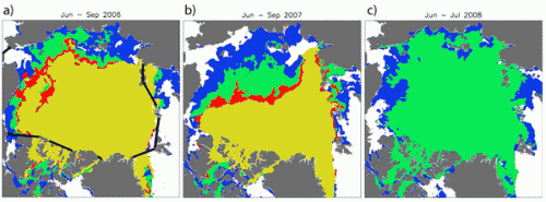
The following Figure from 10 August 2008 and the figures from Lars Kaleschke and Tom Agnew suggest, however, that there were large regions of low sea ice concentrations (black regions) within the boundary of sea ice extent at the end of July. While there may be some difficulty interpreting this figure due to summer melt ponding at the surface, the figure is certainly suggestive of further potential retreat in regions of thin first year sea ice. Such interpretations are important as some scenarios assume complete meltback of all first-year sea ice, while others limit meltback to ice classes thinner than a specific threshold (such as 1m). Total sea ice extent in early August declined at about twice the rate of any other time this summer (Bitz). Ice extent values at the end of the first week in August suggest a different ice evolution than that from the end of July (Stroeve, Kaleschke).

Estimates of top surface and bottom melt from ice mass-balance buoy observations were provided by Don Perovich’s team. The figure below shows the total amount of surface (red) and bottom (yellow) melt through 1 August 2008 measured at seven sea ice mass balance buoys. The current buoy positions are denoted by a circle. The two numbers with each pair of bars are the ice thickness before melt began this spring and on 1 August. The buoys were deployed in conjunction with the North Pole Environmental Observatory (NPEO), the Beaufort Gyre Exploration Project, and the Developing Arctic Modelling and Observing Capabilities for Long-term Environmental Studies (DAMOCLES) program. Similar to 2007 there is anomalously large bottom melt in the southern Beaufort Sea and on the Bering Strait side of the North Pole. The observed surface melt extended across the entire range of typical values between a few centimeters to almost a meter, with some evidence of decreasing surface melt with increasing latitude and distance from the ice edge.
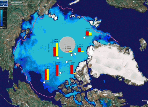
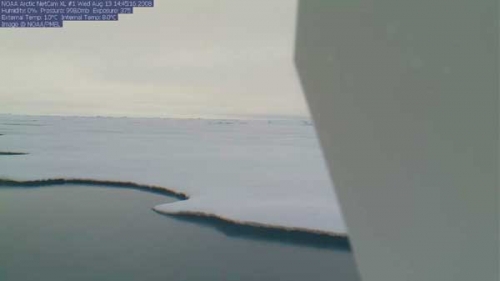
Figure 4 shows the present (13 August 2008) surface condition as evidenced by the web camera image from the NPEO Automated Drifting Station, the location of the ice-mass-balance buoy installation nearest Fram Strait. Unlike previous years at this time, and aside from right around the web camera buoy, we do not see many melt ponds. At this site melt pond coverage has been minimal all summer, arguably due to the limited snow cover in spring. This helps explain why the first-year, 1.9-m ice has only melted 0.2 m on the upper surface and provides one mechanism by which first year ice may survive the summer.
Winds
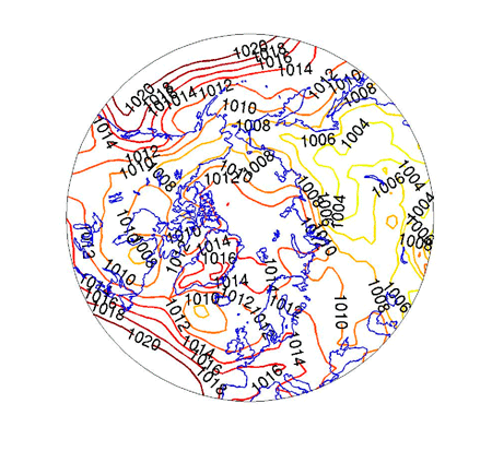
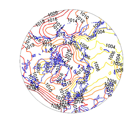
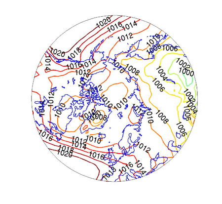
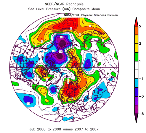
Surface weather patterns are central in driving export, deformation, and compaction of ice, transporting heat and moisture, and are linked to cloud cover. The figure below (Figure 5 a-c) provided by Cecilia Bitz, and similar plots provided by Oleg M. Pokrovsky and the NIC Group, shows the sea level pressure field centered over the Northern Hemisphere for July 2008, July 2007, and for July average conditions (climatology). The numbers are pressure values in millibars; regions of high relative pressures are shown in red and regions of low pressure are shown in yellow. Wind-driven sea ice movement roughly follows these contour lines with higher pressures to the right. Similar plots for June are in the June Report. The climatology field suggests that on average the drift is slow; but in 2007 there was an uncharacteristically strong (for the season) Beaufort High with high pressure on the North American side and lower pressure on the Eurasian side in both June and July. In July 2008 a broad, weak high covered most of the Arctic Ocean with an easterly flow north of Alaska and Eastern Siberia that was generally weaker than in 2007. The July 2008 pattern was consistent with the shift in sea ice conditions with more ice on the Siberian side and less in the Beaufort Sea than in 2007. The July 2008 pressure pattern suggests some support for additional sea ice loss compared to climatology, but less than in 2007, and emphasizes loss in the Beaufort Sea over the Chukchi and East Siberian Seas.
Another way to compare Figures 5a and 5b is to compute their difference (Figure 6, provided by Atkinson). When combined with Figure 5a it shows that the Beaufort High was even stronger in 2007 than 2008 and the low pressure north of Siberia was lower in 2007.
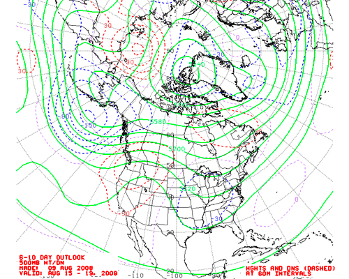
One consideration heading into the last month before September is whether short-term climate forecasts may be helpful in assessing sea ice change. The outlook from the NOAA/NWS Climate Prediction Center (CPC), as well as those of other countries and regions are possibilities. This is important as the whole pressure pattern of June and July (Figure 5a) was projected to shift in early August. The CPC outlook uses an expert approach, combining model forecast information from several forecast centers. The NIC group considered these forecasts. For example figure 7 is the 6–10 day outlook for 15–19 August, made on 9 August 2008, for 500 hPa geopotential height field (solid) and anomalies (dashed, DNS=departure from normal); earlier weather outlooks in August were similar. (This figure gives winds parallel to contours for roughly half way up in the atmosphere, but can reflect lower level wind directions.) The big story here is the complete shift in the weather pattern and winds from July conditions. There are lower heights, and thus perhaps lower SLP, over the Atlantic Arctic and higher heights north of Eastern Siberia. Low heights in the Atlantic side suggest colder temperatures and less sea ice export, while north of Siberia winds are now offshore, which may reverse the persistence of sea ice in that region.
Key Statements from Individual Outlooks
The following section provides a list of contributors, their September 2008 outlook based on July data (in million square kilometers), extracts of key statements that comment on methods and rationale, and links to their full report. Previous estimates made by the contributors from May and June outlooks are shown in brackets [June, May]. The number at the end of each statement provides a link to the full narration. The anticipated September 2008 sea ice extent responses are divided into three categories: more than the sea ice extent of September 2007, approximately the same sea ice extent, and below the sea ice extent of September 2007. Note that these outlooks were provided as a method for a semi-quantitative synthesis, and do not imply that sea ice extent can be forecast to this accuracy.
More than the 2007 Sea Ice Minimum Extent
Stern 5.6 [5.6, 5.6]. Method: Combination of models and data.
There is no explicit physical reasoning—the implicit assumption is that whatever factors drove the sea ice extent to decline approximately linearly during 10 Septembers between 1997–2006, will continue to operate in September 2008.
Stroeve, Serreze, Meier, and Scambos 5.6 [3.5, 3.5]. Method: Based on extrapolation of end of July extent based on 1979–2007 average decline rates through the rest of the melt season. Although the June 2008 ice extent was similar to that seen in 2007, the observed rate of decline slowed in July, resulting in a monthly averaged sea ice extent for July 2008 that was 0.90 million sq-km above 2007. Because of this slow-down, NSIDC changed its forecast methodology to use the average decline rates through the end of the melt season. This approach yields a forecast of 5.6 million square kilometers with a one standard deviation range between 4.6 and 6.4 millions square kilometers. Even at a rate one standard deviation faster than normal, the extent will not fall below last year’s minimum value. However, as of this writing, there has been a sudden drop in ice extent. A strong low pressure system in the Beaufort, first noted on 29 July 2008, has persisted through at least 3 August. It appears that initially, the low pressure system slowed the drop in ice extent by promoting ice divergence. However, in the first few days of August, it now appears the cyclone is fostering ice loss through mechanical ice breakup and enhanced melt. This, along with more vulnerable thinner first-year ice throughout much of the Arctic, suggests a faster than normal decline through the rest of the melt season. So, this year’s extent is likely to be toward the lower end of our forecast range (i.e., closer to 4.6 than 5.6 millions square kilometer) but appears unlikely that it will match the 2007 low.
Hori 5.4. Method: comparison to 2007 weather and satellite data. We have been monitoring daily changes of the Arctic sea ice extent using AMSR-E data. The trend of sea ice extent in July 2008 is following those of 2005 and 2006 (i.e., second minimum extent). This year’s sea ice thickness in spring can be estimated to be the thinnest among the recent 6 years. On the other hand, the summer weather condition so far observed this year is not necessarily favorable to sea ice melting. Our analysis of cloudiness anomalies during June and July derived from MODIS data indicates that it was mostly cloudy over north of the Eastern Siberia Sea where much sea ice remains this July.
Kaleschke 5.4 [5.6, 3.8]. (Value was then revised downward to 5.0 based on 12 August data). Method: Daily updated statistical regression based on sea ice concentration derived from 85 GHz SSM/I data. As we approach the summer sea ice minimum, a skillful prediction is feasible based on the presently observed sea ice area. Several algorithms exist to calculate the sea ice concentration from passive microwave data. Here, the ARTIST Sea Ice (ASI) algorithm is used to derive the sea ice concentration from SSM/I data. A validation with ship based observations in the summer season showed the good performance of the ASI algorithm in terms of standard deviation and correlation to the ground truth.
Bitz 5.3 [5.3, 5.3]. Method: Statistical, based on observations and coupled climate model. With little deviation from the long term trend in July 2008 and no significant autocorrelation or skew from one September to the next in the observations, the conservative estimate for the future is on the trend line in September. An extrapolation of the trend line to year 2008 gives 5.30 million square kilometers.
Agnew 5.3 [June = 5.3]. Over monthly to seasonal time scales, persistence of the anomaly is pretty hard to beat. Summer of 2008 is very similar to 2005 although the two years are quite different regionally. Summer of 2008 shows a large region of less sea ice than normal over the Beaufort Sea compared to 2005 which had less ice cover than normal in the Eastern Siberian Sea and Laptev Sea. Both years show more ice in the Canadian Archipelago compared to 2007.
Zhang 5.1 [4.6, 4.5]. Method: Numerical Model.
The predicted ensemble median of September 2008 ice extent is 5.1 million square kilometers. This is based on ensemble predictions starting on 1 August 2008. See previous months for discussion of method.
Kwok 5.0 [5.0, 5.0]. Method: Satellite data. See earlier Outlooks for discussion.
About the Same as the 2007 Sea Ice Minimum Extent:
Drobot, Maslanik, and Fowler 4.9 [4.4, 3.8]. Method: Probabilistic statistical
model and subjective analyses of weather data. Compared to last year at this time, the sea ice extent is now much greater, but the ice age data indicates that the ice pack is more vulnerable to loss this year. While atmospheric conditions through July have tended to favor retention of ice in the Arctic Basin, circulation patterns over the past several days and forecasted for the next week are likely to add an additional, transport-related, component to the retreat in ice extent, particularly in the Siberian Arctic. The rate of ice extent loss should accelerate over the next week to two weeks, given these conditions.
Pokrovsky 4.6 [4.4, 4.4]. Method: Weather and sea ice trends. Persisted air circulation system in Northern Pacific provided permanent inflow of warm air to Alaska/Canada sector of Arctic and outflow cooled air through the Eastern Siberian sector of Arctic. Thus, in the former domain one can find less ice sheet cover than in last year, but the latter is fully covered with ice. There is a general negative trend of SST in the North Pacific. July satellite data demonstrates that this factor is enforced during last month. In general, the Pacific sector of the Arctic will be more ice covered than in 2007. Northward winds in the European sector of Arctic provided usual conditions for ice melting in the Barents Sea and lesser in the Kara Sea.
Pedersen, Tonboe and Dybkjær 4.5. Method: Multiple linear regression estimates September ice extent from: a) Number of freezing degree days the previous winter (proxy for thickness of FY ice); b) End of April multi-year ice extent (the last reliable measure of MY-ice extent from scatterometer data) and c) July total ice extent.
(AWI)—Kauker, Gerdes, and Karcher 4.5 [June = 4.4]. Method: Numerical Model-Ensemble forced with NCEP/NCAR reanalysis data. For the July outlook we ran the coupled ocean-ice model NAOSIM with NCEP forcing until 7 August 2008. The ensemble experiment starts from these initial conditions. With a probability of 80% the minimum ice extent in 2008 will be in the range between 4.3 and 4.7 million km2.
Miles 4.4 [May = 3.8] Method: Semi-empirical / semi-theoretical. Our latest estimate of 4.4 million square kilometers is an upward adjustment of 0.6 from our May outlook. Atmospheric-circulation patterns in June–July were generally favorable for preservation of sea ice, at least compared to the same period in summer 2007. Assuming the patterns in August–September are neutral, then our expectation is that sea ice decreases may yet approach the record minimum in 2007, the reason being the susceptibility of the predominantly first-year ice cover and the large areas of reduced sea ice concentration evident in the late July AMSR-E image data.
Prinsenberg 4.3 [May = 4.2]. Ice extent, will probably be the same as last year, as a rebound before dropping off sharply the following year. All depends on the radiation and clouds presently in the Beaufort Sea.
Less than the 2007 Sea Ice Minimum Extent
(NIC)—Arbetter, Clemente-Colón, Szorc, Holden and Rigor 3.3 [June = 2.9]. Method: First year Ice Scenarios. Cumulative ice motions for April–July 2008 derived from drift buoys indicate the overall transport of ice out of the Beaufort Sea around the Beaufort Gyre to the central Arctic was actually much stronger than in 2007, but it appears to be converging (motion is slowing) over the Amundsen and Nansen Basins. In 2007, the cumulative transport was stronger from the Eurasian coast toward Fram Strait with a smaller region of convergence. On the other hand, ice that reaches Fram Strait is exported faster in 2008 than in 2007. Actual visual observations of sea ice recently made from aircraft during buoy deployment operations over the Arctic by the Naval Oceanographic Office and National Guard confirm that the ice cover is noticeably thinner and that it is more fractured than in previous years. A fundamental assumption by NIC is that this FYI will melt out in greater amounts than MYI.
Rigor, Clemente-Colón, Nghiem, Woods, Brinkley, Arbetter 3.2 [3.1, 3.1]. Method: Based on a buoy drift model that estimates the age of sea ice, QuikSCAT retrievals of ice age classes, and the survival rates of each age class.
Regional Outlooks
We have five regional outlooks:
Eicken for Alaskan Waters
Landfast ice disintegrated somewhat later (about one week) in the region than last year, but was already unstable and unsafe in many areas prior to that. Ice retreat is now lagging behind last year’s pace in the Chukchi Sea due to surface circulation and lack of warm weather. Most of the first-year ice formed in the Beaufort and eastern Chukchi Sea during winter has now been removed by melt. However, complete meltback of multiyear ice advected from the North in late spring (see May Sea Ice Outlook) is increasingly unlikely as the melt season enters into its final stages. As indicated in the previous outlook for the region, fields of rotten multiyear ice persist off the northern coast of Alaska, with potential impacts on marine mammals (providing a platform for foraging walrus well into the season) and ship traffic.
Gerland and Goodwin for the Barents Sea and East Greenland
The relationship between the present ice extent and earlier extents in the Barents Sea changed relative to June 2008. Comparing the mean extent for 1999–2008, with the July 2008 extent we see a slightly greater ice extent west of Franz Josef Land (FJL), and a slightly smaller extent east of FJL. East of FJL (but quite close to it), the ice edge in July 2008 was further north than in July 2007. When comparing the ice extent for July 2007 with that of 2008 between Svalbard and FJL, the ice edge was much further north in 2007 than in 2008. This correlates with the general speed of seasonal ice reduction for the entire Arctic during July 2008 and 2007 and earlier as published on the NSIDC website.
Howell and Duguay for the Northwest Passage
As of 28 July 2008, multi-year ice (MYI) in the Western Parry Channel region of the Northwest Passage has remained relatively unchanged and the Canadian Arctic Archipelago itself still contains high sea ice concentrations. Breakup in this region of the Northwest Passage is now just getting underway and when the FYI eventually breaks up this will cause the MYI to become mobile.
Newbury for Pt. Barrow
A huge storm took out a house in Wainwright and pushed a great deal of ice to shore at Pt. Barrow, closing off the route around the point for several oil and gas vessels. The ice might be blown back out this weekend.
Pokrovsky for Russian waters
It is probable that east-west passage in East Siberia (Laptev and East-Siberian Seas) will be mainly ice covered in September. In contrast, a major part of the Alaska/Canadian coastline will be free of ice.
| Attachment | Size |
|---|---|
| Download All Individual July 2008 Outlook Submissions (PDF - 4.5 MB)4.46 MB | 4.46 MB |
| Attachment | Size |
|---|---|
| Agnew204.78 KB | 204.78 KB |
| Arbetter et al.7.32 MB | 7.32 MB |
| Bitz65.36 KB | 65.36 KB |
| Drobot et al.119.24 KB | 119.24 KB |
| Eicken125.55 KB | 125.55 KB |
| Gerland and Goodwin5.76 MB | 5.76 MB |
| Hori10.53 MB | 10.53 MB |
| Howell and Duguay1.5 MB | 1.5 MB |
| Hutchings66.8 KB | 66.8 KB |
| Kaleschke980.99 KB | 980.99 KB |
| Kauker et al.243.24 KB | 243.24 KB |
| Kwok1.33 MB | 1.33 MB |
| Miles56.24 KB | 56.24 KB |
| Newbury17.13 KB | 17.13 KB |
| Pederson113.32 KB | 113.32 KB |
| Perovich et al.341.43 KB | 341.43 KB |
| Pokrovsky267.67 KB | 267.67 KB |
| Prinsenberg47.87 KB | 47.87 KB |
| Rigor et al.876 KB | 876 KB |
| Stern46.71 KB | 46.71 KB |
| Stroeve et al.189.83 KB | 189.83 KB |
| Zhang262.9 KB | 262.9 KB |


